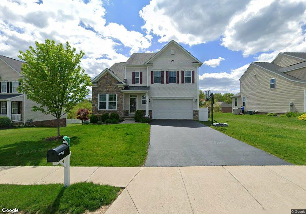
243 Dupont Dr Mc Donald, PA 15057
Estimated Value: $496,000 - $551,000
4
Beds
3
Baths
2,834
Sq Ft
$183/Sq Ft
Est. Value
About This Home
This home is located at 243 Dupont Dr, Mc Donald, PA 15057 and is currently estimated at $520,025, approximately $183 per square foot. 243 Dupont Dr is a home with nearby schools including West Allegheny Senior High School.
Ownership History
Date
Name
Owned For
Owner Type
Purchase Details
Closed on
Jan 28, 2021
Sold by
Drummond Eric W
Bought by
Drummond Eric W and Drummond April
Current Estimated Value
Home Financials for this Owner
Home Financials are based on the most recent Mortgage that was taken out on this home.
Original Mortgage
$256,500
Outstanding Balance
$229,013
Interest Rate
2.6%
Mortgage Type
New Conventional
Estimated Equity
$291,012
Purchase Details
Closed on
Jan 25, 2021
Sold by
Drummond Eric W
Bought by
Drummond Eric W and Drummond April
Home Financials for this Owner
Home Financials are based on the most recent Mortgage that was taken out on this home.
Original Mortgage
$256,500
Outstanding Balance
$229,013
Interest Rate
2.6%
Mortgage Type
New Conventional
Estimated Equity
$291,012
Purchase Details
Closed on
Dec 22, 2014
Sold by
Dan Ryan Bldrs Mid Atlantic In
Bought by
Drummond Eric W
Home Financials for this Owner
Home Financials are based on the most recent Mortgage that was taken out on this home.
Original Mortgage
$282,315
Interest Rate
4.02%
Mortgage Type
New Conventional
Create a Home Valuation Report for This Property
The Home Valuation Report is an in-depth analysis detailing your home's value as well as a comparison with similar homes in the area
Home Values in the Area
Average Home Value in this Area
Purchase History
| Date | Buyer | Sale Price | Title Company |
|---|---|---|---|
| Drummond Eric W | -- | None Available | |
| Drummond Eric W | -- | -- | |
| Drummond Eric W | $313,685 | -- |
Source: Public Records
Mortgage History
| Date | Status | Borrower | Loan Amount |
|---|---|---|---|
| Open | Drummond Eric W | $256,500 | |
| Previous Owner | Drummond Eric W | $282,315 |
Source: Public Records
Tax History Compared to Growth
Tax History
| Year | Tax Paid | Tax Assessment Tax Assessment Total Assessment is a certain percentage of the fair market value that is determined by local assessors to be the total taxable value of land and additions on the property. | Land | Improvement |
|---|---|---|---|---|
| 2025 | $7,468 | $281,500 | $40,000 | $241,500 |
| 2024 | $7,468 | $281,500 | $40,000 | $241,500 |
| 2023 | $7,468 | $281,500 | $40,000 | $241,500 |
| 2022 | $7,946 | $281,500 | $40,000 | $241,500 |
| 2021 | $7,410 | $279,300 | $40,000 | $239,300 |
| 2020 | $7,410 | $279,300 | $40,000 | $239,300 |
| 2019 | $7,410 | $279,300 | $40,000 | $239,300 |
| 2018 | $1,272 | $269,000 | $40,000 | $229,000 |
| 2017 | $7,137 | $269,000 | $40,000 | $229,000 |
| 2016 | $1,358 | $287,000 | $40,000 | $247,000 |
| 2015 | $1,358 | $287,000 | $40,000 | $247,000 |
| 2014 | $7,614 | $6,000 | $6,000 | $0 |
Source: Public Records
Map
Nearby Homes
- 103 Hollyberry Cir
- 100 Hill Place Dr
- 319 Dupont Dr
- 845 Wall St
- 1103 Hoffman Dr
- 146 Mcvey St
- 1015 Granite Dr
- 809 Station St
- Lot 4 McVey Street Extension
- Lot 3 McVey Street Extension
- 7712 Noblestown Rd
- 0 McVey St Extension Unit 1692515
- Lot 3166 Robinson Run Rd
- 238 State St W
- 205 Spring St
- 403 Clinton Ave
- 222 Hastings Ave
- 4401 Battle Ridge Rd
- Carlisle Plan at Stonegate
- Tucson Plan at Stonegate