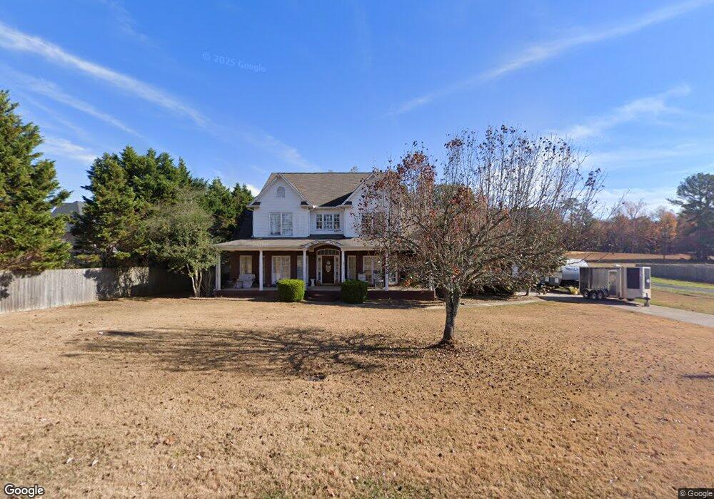
243 Dupree Dr Huntsville, AL 35806
Monrovia NeighborhoodEstimated Value: $473,898 - $620,000
--
Bed
1
Bath
3,228
Sq Ft
$164/Sq Ft
Est. Value
About This Home
This home is located at 243 Dupree Dr, Huntsville, AL 35806 and is currently estimated at $528,975, approximately $163 per square foot. 243 Dupree Dr is a home with nearby schools including Legacy Elementary School, Monrovia Middle School, and Sparkman High School.
Ownership History
Date
Name
Owned For
Owner Type
Purchase Details
Closed on
Jan 22, 2008
Sold by
Pierce Charles and Pierce Karen
Bought by
Pierce Charles
Current Estimated Value
Home Financials for this Owner
Home Financials are based on the most recent Mortgage that was taken out on this home.
Original Mortgage
$192,000
Interest Rate
5.24%
Mortgage Type
New Conventional
Purchase Details
Closed on
Aug 31, 2005
Sold by
Dysart Jeff C and Dysart April K
Bought by
Pierce Charles W and Pierce Karen T
Home Financials for this Owner
Home Financials are based on the most recent Mortgage that was taken out on this home.
Original Mortgage
$195,000
Interest Rate
5.64%
Mortgage Type
New Conventional
Create a Home Valuation Report for This Property
The Home Valuation Report is an in-depth analysis detailing your home's value as well as a comparison with similar homes in the area
Home Values in the Area
Average Home Value in this Area
Purchase History
| Date | Buyer | Sale Price | Title Company |
|---|---|---|---|
| Pierce Charles | -- | -- | |
| Pierce Charles W | $243,750 | -- |
Source: Public Records
Mortgage History
| Date | Status | Borrower | Loan Amount |
|---|---|---|---|
| Previous Owner | Pierce Charles | $192,000 | |
| Previous Owner | Pierce Charles W | $195,000 |
Source: Public Records
Tax History Compared to Growth
Tax History
| Year | Tax Paid | Tax Assessment Tax Assessment Total Assessment is a certain percentage of the fair market value that is determined by local assessors to be the total taxable value of land and additions on the property. | Land | Improvement |
|---|---|---|---|---|
| 2024 | $1,553 | $44,020 | $1,880 | $42,140 |
| 2023 | $1,553 | $42,500 | $1,880 | $40,620 |
| 2022 | $1,303 | $37,100 | $1,200 | $35,900 |
| 2021 | $1,211 | $34,580 | $1,200 | $33,380 |
| 2020 | $1,128 | $32,320 | $1,200 | $31,120 |
| 2019 | $1,077 | $30,920 | $1,200 | $29,720 |
| 2018 | $989 | $28,500 | $0 | $0 |
| 2017 | $989 | $28,500 | $0 | $0 |
| 2016 | $989 | $28,500 | $0 | $0 |
| 2015 | $989 | $28,500 | $0 | $0 |
| 2014 | $997 | $28,720 | $0 | $0 |
Source: Public Records
Map
Nearby Homes
- 104 Raymon Cir
- 109 Sarah Jane Dr
- 124 Huston Ct
- 1.4 acres Jeff Rd NW
- 10.4 acres Jeff Rd NW
- 1 ACRE EASEMENT Jeff Rd NW
- 2031 Blake Bottom Rd NW Unit 15
- 2031 Blake Bottom Rd NW
- 2031 Blake Bottom Rd NW Unit 2
- 253 Pumprock Dr
- 989 Jeff Rd NW
- 436 Mount Zion Rd
- 229 Brooklet Ct
- 223 Wainscott Dr
- 482 Mount Zion Rd
- 195 Sarah Jane Dr
- 108 Conifer Ct
- 150 Blue Spruce Dr
- 200 Sarah Jane Dr
- 115 Misty Hollow Way
- 235 Dupree Dr
- 209 Dupree Dr
- 189 Dupree Dr
- 199 Dupree Dr
- 221 Dupree Dr
- 110 Summer Brook Ct
- 106 Summer Brook Ct
- 104 Summer Brook Ct
- 212 Dupree Dr
- 198 Dupree Dr
- 123 Tindall Dr
- 222 Dupree Dr
- 121 Tindall Dr
- 234 Dupree Dr
- 100 Summer Brook Ct
- 186 Dupree Dr
- 122 Shoalford Dr
- 246 Dupree Dr
- 124 Shoalford Dr
- 125 Tindall Dr