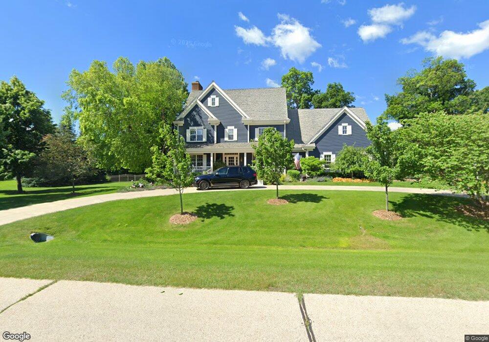
243 E Laurel Cir Delafield, WI 53018
Estimated Value: $1,738,571 - $2,471,000
4
Beds
5
Baths
--
Sq Ft
99,752
Sq Ft Lot
About This Home
This home is located at 243 E Laurel Cir, Delafield, WI 53018 and is currently estimated at $1,992,190. 243 E Laurel Cir is a home located in Waukesha County with nearby schools including Cushing Elementary School, Kettle Moraine Middle School, and Kettle Moraine High School.
Ownership History
Date
Name
Owned For
Owner Type
Purchase Details
Closed on
Feb 10, 2026
Sold by
Koss Scott A and Koss Paula A
Bought by
Koss 2021 Revocable Trust
Current Estimated Value
Home Financials for this Owner
Home Financials are based on the most recent Mortgage that was taken out on this home.
Original Mortgage
$1,129,500
Outstanding Balance
$1,129,500
Interest Rate
6.16%
Mortgage Type
New Conventional
Estimated Equity
$862,690
Purchase Details
Closed on
Jun 11, 2009
Sold by
Ciabotti Douglas and Ciabotti Jane
Bought by
Koss Scott A and Koss Paula A
Home Financials for this Owner
Home Financials are based on the most recent Mortgage that was taken out on this home.
Original Mortgage
$417,000
Interest Rate
4.92%
Mortgage Type
Purchase Money Mortgage
Purchase Details
Closed on
Oct 24, 2001
Sold by
Bostrom Elizabeth and Loepfe Robert P
Bought by
Ciabotti Douglas and Ciabotti Jane
Create a Home Valuation Report for This Property
The Home Valuation Report is an in-depth analysis detailing your home's value as well as a comparison with similar homes in the area
Home Values in the Area
Average Home Value in this Area
Purchase History
| Date | Buyer | Sale Price | Title Company |
|---|---|---|---|
| Koss 2021 Revocable Trust | -- | None Listed On Document | |
| Koss Scott A | $1,025,000 | Priority Title Corporation | |
| Ciabotti Douglas | $125,000 | -- |
Source: Public Records
Mortgage History
| Date | Status | Borrower | Loan Amount |
|---|---|---|---|
| Open | Koss 2021 Revocable Trust | $1,129,500 | |
| Previous Owner | Koss Scott A | $417,000 |
Source: Public Records
Tax History
| Year | Tax Paid | Tax Assessment Tax Assessment Total Assessment is a certain percentage of the fair market value that is determined by local assessors to be the total taxable value of land and additions on the property. | Land | Improvement |
|---|---|---|---|---|
| 2024 | $17,833 | $1,330,200 | $227,600 | $1,102,600 |
| 2023 | $17,389 | $1,330,200 | $227,600 | $1,102,600 |
| 2022 | $16,770 | $1,330,200 | $227,600 | $1,102,600 |
| 2021 | $16,575 | $1,024,100 | $191,300 | $832,800 |
| 2020 | $16,640 | $1,024,100 | $191,300 | $832,800 |
| 2019 | $16,015 | $1,024,100 | $191,300 | $832,800 |
| 2018 | $15,280 | $1,001,600 | $191,300 | $810,300 |
| 2017 | $15,023 | $1,001,600 | $191,300 | $810,300 |
| 2016 | $15,273 | $1,001,600 | $191,300 | $810,300 |
| 2015 | $15,785 | $1,001,600 | $191,300 | $810,300 |
| 2014 | $16,615 | $1,001,600 | $191,300 | $810,300 |
| 2013 | $16,615 | $1,011,000 | $193,500 | $817,500 |
Source: Public Records
Map
Nearby Homes
- 545 Wisconsin Ave
- 2736 Nagawicka Ave
- 3024 Nagawicka Ave
- 805 Wells St Unit 4
- 805 Wells St Unit 2
- 805 Wells St Unit 3
- 805 Wells St Unit 1
- N40W33325 Woodsview Dr
- 323 Riverview Dr Unit 4
- 1213 Main St
- 1001 Park Way
- 1026 Park Way
- N41W33425 Nashotah Rd
- 637 1st St
- 3082 Monona Ct
- 2826 Yahara Dr
- N43W32801 Rasmus Rd Unit 9D
- N43W32953 Rasmus Rd Unit 3-H
- 35097 Yahara Dr
- 1815 Bark River Dr
- 251 E Laurel Cir
- 250 E Laurel Cir
- 234 E Laurel Cir
- 235 E Laurel Cir
- 259 E Laurel Cir
- 258 E Laurel Cir
- 228 E Laurel Cir
- 266 E Laurel Cir
- 227 E Laurel Cir
- 267 E Laurel Cir
- 222 E Laurel Cir
- 219 E Laurel Cir
- 314 Copperfield Dr
- 2055 Hillcrest Dr
- 216 E Laurel Cir
- 156 N Fieldstone Rd
- 2001 Hillcrest Dr
- 1989 Hillcrest Dr
- 2091 Hillcrest Dr
- 320 Copperfield Dr
Your Personal Tour Guide
Ask me questions while you tour the home.