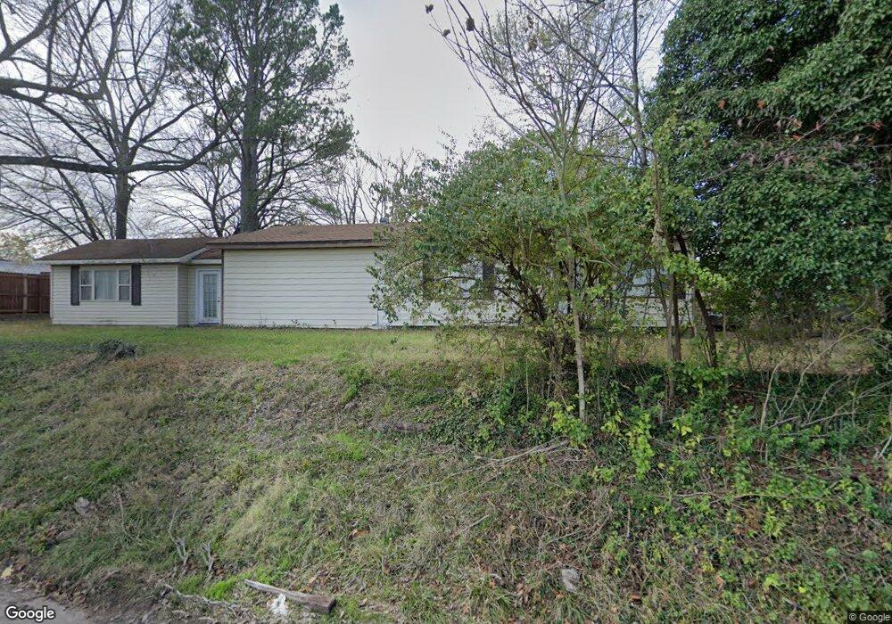
243 S Campbell Ave West Fork, AR 72774
Estimated Value: $220,773 - $278,000
2
Beds
1
Bath
1,310
Sq Ft
$189/Sq Ft
Est. Value
About This Home
This home is located at 243 S Campbell Ave, West Fork, AR 72774 and is currently estimated at $247,193, approximately $188 per square foot. 243 S Campbell Ave is a home located in Washington County with nearby schools including West Fork Elementary School, West Fork Middle School, and West Fork High School.
Ownership History
Date
Name
Owned For
Owner Type
Purchase Details
Closed on
Jan 13, 2016
Bought by
Robison Carol C
Current Estimated Value
Purchase Details
Closed on
Aug 21, 2015
Bought by
Cl Webb Construction Services Llc
Purchase Details
Closed on
Jul 8, 2015
Bought by
Eagle Holdings Llc
Purchase Details
Closed on
Apr 6, 2011
Sold by
Baker Cleet D and Baker Cleet A
Bought by
West Misty Dawn
Home Financials for this Owner
Home Financials are based on the most recent Mortgage that was taken out on this home.
Original Mortgage
$68,393
Interest Rate
4.98%
Mortgage Type
New Conventional
Purchase Details
Closed on
Dec 4, 1996
Bought by
Hames Michael Brent and Carolynn Lee
Purchase Details
Closed on
Jan 27, 1989
Bought by
Barnes Jack
Purchase Details
Closed on
Jan 1, 1985
Bought by
Barnes Jack
Create a Home Valuation Report for This Property
The Home Valuation Report is an in-depth analysis detailing your home's value as well as a comparison with similar homes in the area
Home Values in the Area
Average Home Value in this Area
Purchase History
| Date | Buyer | Sale Price | Title Company |
|---|---|---|---|
| Robison Carol C | $78,500 | -- | |
| Cl Webb Construction Services Llc | $43,000 | -- | |
| Eagle Holdings Llc | -- | -- | |
| West Misty Dawn | $66,000 | Rtc | |
| Hames Michael Brent | -- | -- | |
| Barnes Jack | -- | -- | |
| Barnes Jack | -- | -- |
Source: Public Records
Mortgage History
| Date | Status | Borrower | Loan Amount |
|---|---|---|---|
| Previous Owner | West Misty Dawn | $68,393 |
Source: Public Records
Tax History Compared to Growth
Tax History
| Year | Tax Paid | Tax Assessment Tax Assessment Total Assessment is a certain percentage of the fair market value that is determined by local assessors to be the total taxable value of land and additions on the property. | Land | Improvement |
|---|---|---|---|---|
| 2025 | $291 | $35,140 | $6,000 | $29,140 |
| 2024 | $390 | $35,140 | $6,000 | $29,140 |
| 2023 | $470 | $35,140 | $6,000 | $29,140 |
| 2022 | $520 | $22,930 | $3,500 | $19,430 |
| 2021 | $520 | $22,930 | $3,500 | $19,430 |
| 2020 | $520 | $22,930 | $3,500 | $19,430 |
| 2019 | $520 | $16,850 | $3,000 | $13,850 |
| 2018 | $545 | $16,850 | $3,000 | $13,850 |
| 2017 | $519 | $16,850 | $3,000 | $13,850 |
| 2016 | $519 | $16,850 | $3,000 | $13,850 |
| 2015 | $519 | $16,850 | $3,000 | $13,850 |
| 2014 | $467 | $15,830 | $4,000 | $11,830 |
Source: Public Records
Map
Nearby Homes
- 302 Mcknight Ave
- 0000 Highway 170
- 185 Wheeler St
- 121 & 129 Main St
- 321 Cedar Springs Place
- 340 W Smith St
- Springs 1445 Plan at Rolling Plains
- Eureka 1536 Plan at Rolling Plains
- Oak 1463 Plan at Rolling Plains
- Magnolia 1556 Plan at Rolling Plains
- Ashton 1496 Plan at Rolling Plains
- Ouachita 1669 Plan at Rolling Plains
- Osage 1567 Plan at Rolling Plains
- Maple 1659 Plan at Rolling Plains
- 393 W Smith St
- 327 W Smith St
- 385 W Smith St
- 365 W Smith St
- 359 W Smith St
- 339 W Smith St
- 243 Campbell Ave
- 233 S Campbell Ave
- 250 Mcknight Ave
- 254 Mcknight Ave
- 246 Mcknight Ave
- . Campbell Community
- 170 S Hwy Ar
- 0 Hwy 170 Unit 276374
- 0 Hwy 170 Unit 280335
- 0 Hwy 170 Unit 376766
- 0 Hwy 170 Unit 292045
- 0 Hwy 170 Unit 294487
- 0 Hwy 170 Unit 296810
- 0 Hwy 170 Unit 296811
- 0 Hwy 170 Unit 296812
- 0 Hwy 170 Unit 366990
- 0 Hwy 170 Unit 370479
- 0 Hwy 170 Unit 371033
- 0 Hwy 170 Unit 361493
- 0 Hwy 170 Unit 373938