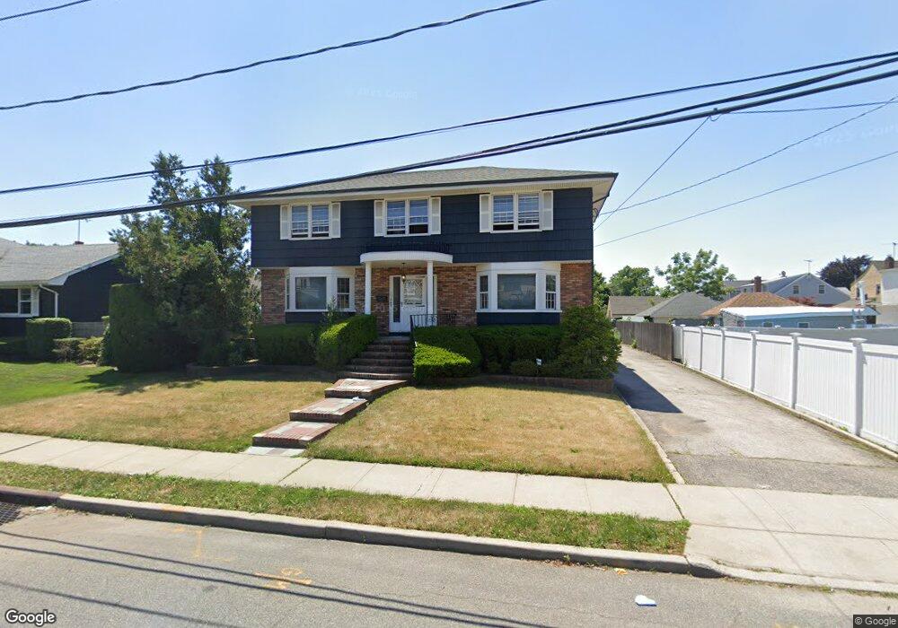
243 Union St Lawrence, NY 11559
Inwood NeighborhoodEstimated Value: $1,273,000 - $1,517,001
4
Beds
2
Baths
2,600
Sq Ft
$537/Sq Ft
Est. Value
About This Home
This home is located at 243 Union St, Lawrence, NY 11559 and is currently estimated at $1,395,001, approximately $536 per square foot. 243 Union St is a home located in Nassau County with nearby schools including Lawrence Primary School, Lawrence Elementary School, and Lawrence Middle School.
Ownership History
Date
Name
Owned For
Owner Type
Purchase Details
Closed on
May 3, 2018
Sold by
Musto Linda and Longobardi Joann
Bought by
Treuhaft Aryeh and Treuhaft Elisheva
Current Estimated Value
Home Financials for this Owner
Home Financials are based on the most recent Mortgage that was taken out on this home.
Original Mortgage
$400,000
Outstanding Balance
$344,730
Interest Rate
4.44%
Mortgage Type
New Conventional
Estimated Equity
$1,050,271
Purchase Details
Closed on
Oct 22, 2009
Sold by
Maietta Jospeh John and Maietta Louise
Bought by
Maietta Michael J and Longobardi Joann
Create a Home Valuation Report for This Property
The Home Valuation Report is an in-depth analysis detailing your home's value as well as a comparison with similar homes in the area
Home Values in the Area
Average Home Value in this Area
Purchase History
| Date | Buyer | Sale Price | Title Company |
|---|---|---|---|
| Treuhaft Aryeh | $760,000 | Stewart Title | |
| Maietta Michael J | -- | -- |
Source: Public Records
Mortgage History
| Date | Status | Borrower | Loan Amount |
|---|---|---|---|
| Open | Treuhaft Aryeh | $400,000 |
Source: Public Records
Tax History Compared to Growth
Tax History
| Year | Tax Paid | Tax Assessment Tax Assessment Total Assessment is a certain percentage of the fair market value that is determined by local assessors to be the total taxable value of land and additions on the property. | Land | Improvement |
|---|---|---|---|---|
| 2025 | $12,104 | $749 | $218 | $531 |
| 2024 | $5,302 | $738 | $215 | $523 |
| 2023 | $12,484 | $760 | $221 | $539 |
| 2022 | $12,484 | $760 | $221 | $539 |
| 2021 | $17,110 | $729 | $241 | $488 |
| 2020 | $14,444 | $1,238 | $576 | $662 |
| 2019 | $5,521 | $1,238 | $576 | $662 |
| 2018 | $7,397 | $1,238 | $0 | $0 |
| 2017 | $6,769 | $1,238 | $576 | $662 |
| 2016 | $11,744 | $1,238 | $576 | $662 |
| 2015 | $4,735 | $1,238 | $576 | $662 |
| 2014 | $4,735 | $1,238 | $576 | $662 |
| 2013 | $4,148 | $1,238 | $576 | $662 |
Source: Public Records
Map
Nearby Homes
- 227 Randall Ave
- 347 Roselle Ave
- 284 Central Ave Unit D6
- 284 Central Ave Unit A4
- 23 Park Ave
- 218 Avery Place
- 250 Central Ave Unit e218
- 250 Central Ave Unit B204
- 324 Buckingham Rd
- 360 Central Ave Unit 331
- 240 Central Ave Unit 2 F
- 260 Central Ave Unit 135
- 260 Central Ave Unit 430
- 285 Central Ave Unit D-7
- 285 Central Ave Unit B-4
- 285 Central Ave Unit D6
- 230 Central Ave Unit 2-H
- 230 Central Ave Unit 1-F
- 230 Central Ave Unit 3J
- 230 Central Ave Unit 1C