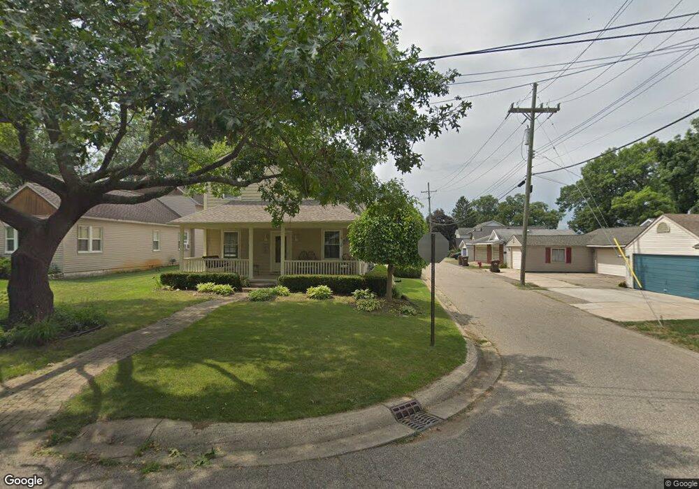
2430 Hoover Ave West Bloomfield, MI 48324
Estimated Value: $335,002 - $409,000
3
Beds
3
Baths
1,951
Sq Ft
$191/Sq Ft
Est. Value
About This Home
This home is located at 2430 Hoover Ave, West Bloomfield, MI 48324 and is currently estimated at $372,751, approximately $191 per square foot. 2430 Hoover Ave is a home located in Oakland County with nearby schools including Clifford H. Smart Middle School, Walled Lake Northern High School, and Our Lady Of Refuge School.
Ownership History
Date
Name
Owned For
Owner Type
Purchase Details
Closed on
Nov 7, 2017
Sold by
Rosin Jane E and Weisling Jane E
Bought by
Weisling Jane E and The Jane E Weisling Trust
Current Estimated Value
Purchase Details
Closed on
Apr 17, 2002
Sold by
Lynn Nichole M
Bought by
Weisling Avery
Purchase Details
Closed on
Jan 5, 2000
Sold by
Pressley Nichole M
Bought by
Lynn Nichole M
Purchase Details
Closed on
Aug 14, 1997
Sold by
Ries Richard H
Bought by
Pressley Nichole M
Create a Home Valuation Report for This Property
The Home Valuation Report is an in-depth analysis detailing your home's value as well as a comparison with similar homes in the area
Home Values in the Area
Average Home Value in this Area
Purchase History
| Date | Buyer | Sale Price | Title Company |
|---|---|---|---|
| Weisling Jane E | -- | None Available | |
| Weisling Avery | $250,500 | -- | |
| Lynn Nichole M | -- | -- | |
| Pressley Nichole M | $109,900 | -- |
Source: Public Records
Tax History Compared to Growth
Tax History
| Year | Tax Paid | Tax Assessment Tax Assessment Total Assessment is a certain percentage of the fair market value that is determined by local assessors to be the total taxable value of land and additions on the property. | Land | Improvement |
|---|---|---|---|---|
| 2024 | $1,070 | $94,860 | $0 | $0 |
| 2023 | $1,009 | $88,220 | $0 | $0 |
| 2022 | $1,707 | $84,350 | $0 | $0 |
| 2021 | $1,670 | $77,660 | $0 | $0 |
| 2020 | $997 | $74,800 | $0 | $0 |
| 2019 | $1,588 | $71,820 | $0 | $0 |
| 2018 | $1,570 | $61,920 | $0 | $0 |
| 2017 | $1,547 | $61,920 | $0 | $0 |
| 2016 | $1,528 | $58,630 | $0 | $0 |
| 2015 | -- | $53,980 | $0 | $0 |
| 2014 | -- | $49,910 | $0 | $0 |
| 2011 | -- | $41,820 | $0 | $0 |
Source: Public Records
Map
Nearby Homes
- 2841 Treyburn Ln
- 2498 Sunset Terrace Ln
- VAC Massena Ave
- 2484 Horace St
- 7607 Mapleton Ct
- 8541 Joseph St
- 8511 Joseph St
- 1990 Union Lake Rd
- 8636 War Bonnet Dr
- 7260 Willow Oak Dr
- 8470 Wise Rd
- 8650 Buffalo Dr
- 7543 Greenway Ln
- Richfield Plan at Rosewood - Detached Ranch Condos
- 7240 Aaronway Dr
- 7304 Ilanaway Dr
- 8723 Ringwood Dr
- 3280 Chambourne St
- 7185 Aaronway Dr
- 3115 Westacres Dr
- 2430 Hoover Ave
- 2440 Hoover Ave
- 2440 Hoover Ave
- 2450 Hoover Ave
- 2450 Hoover Ave
- 8018 Barnsbury St
- 8012 Barnsbury St
- 8024 Barnsbury St
- 8006 Barnsbury St
- 2460 Hoover Ave
- 2460 Hoover Ave
- 2441 Greenlawn Ave
- 8030 Barnsbury St
- 8036 Barnsbury St
- 2470 Hoover Ave
- 2470 Hoover Ave
- 8039 Barnsbury St
- 2471 Greenlawn Ave
- 2451 Greenlawn Ave Unit Bldg-Unit
- 2451 Greenlawn Ave