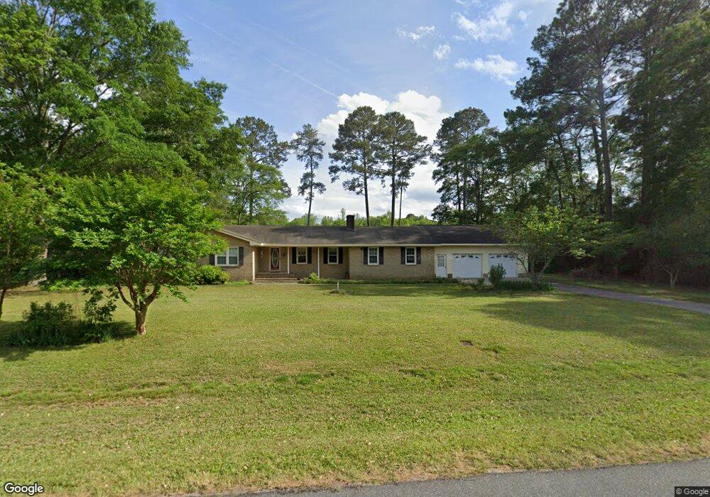
2439 Forrest Dr Kinston, NC 28504
Estimated Value: $274,000 - $290,359
3
Beds
2
Baths
2,077
Sq Ft
$136/Sq Ft
Est. Value
About This Home
This home is located at 2439 Forrest Dr, Kinston, NC 28504 and is currently estimated at $282,180, approximately $135 per square foot. 2439 Forrest Dr is a home located in Lenoir County with nearby schools including Banks Elementary School, E.B. Frink Middle School, and North Lenoir High School.
Ownership History
Date
Name
Owned For
Owner Type
Purchase Details
Closed on
Mar 15, 2010
Sold by
Sizemore Marvin P and Sizemore Helen S
Bought by
Becker Michael Joseph and Becker Diane Renee
Current Estimated Value
Home Financials for this Owner
Home Financials are based on the most recent Mortgage that was taken out on this home.
Original Mortgage
$124,000
Outstanding Balance
$81,235
Interest Rate
4.75%
Mortgage Type
New Conventional
Estimated Equity
$200,945
Create a Home Valuation Report for This Property
The Home Valuation Report is an in-depth analysis detailing your home's value as well as a comparison with similar homes in the area
Home Values in the Area
Average Home Value in this Area
Purchase History
| Date | Buyer | Sale Price | Title Company |
|---|---|---|---|
| Becker Michael Joseph | $129,000 | -- |
Source: Public Records
Mortgage History
| Date | Status | Borrower | Loan Amount |
|---|---|---|---|
| Open | Becker Michael Joseph | $124,000 |
Source: Public Records
Tax History
| Year | Tax Paid | Tax Assessment Tax Assessment Total Assessment is a certain percentage of the fair market value that is determined by local assessors to be the total taxable value of land and additions on the property. | Land | Improvement |
|---|---|---|---|---|
| 2025 | $2,030 | $267,808 | $65,490 | $202,318 |
| 2024 | $1,351 | $139,746 | $25,540 | $114,206 |
| 2023 | $1,351 | $139,746 | $25,540 | $114,206 |
| 2022 | $1,351 | $139,746 | $25,540 | $114,206 |
| 2021 | $1,348 | $139,746 | $25,540 | $114,206 |
| 2020 | $1,348 | $139,746 | $25,540 | $114,206 |
| 2019 | $1,351 | $139,746 | $25,540 | $114,206 |
| 2018 | $1,330 | $139,746 | $25,540 | $114,206 |
| 2017 | $1,251 | $139,746 | $25,540 | $114,206 |
| 2014 | $1,468 | $157,254 | $16,500 | $140,754 |
| 2013 | -- | $125,085 | $16,500 | $108,585 |
| 2011 | -- | $125,085 | $16,500 | $108,585 |
Source: Public Records
Map
Nearby Homes
- 0 Dogwood Ln Unit 100189056
- 2131 Brinson St
- 2634 Forrest Dr
- 2193 Dogwood Ln
- 2111 Hunt Hill Place
- 1729 Holly Ridge Rd
- 1801 Crestview St
- 2012 Hwy 258 N
- 11 Brookwood Rd
- 2443 Creekside Rd
- 2917 Laurel Ridge Ln
- 1596 Hwy 258 N
- 2111 Westwood Dr
- 2671 Brookwood Rd
- 3807 Random Rd
- 2585 Cabin Branch Rd
- 2857 Branchwood Dr
- 2146 Crescent Dr
- 2204 Staley Ct
- 3128 Kelly Rd
- 2429 Forrest Dr
- 2440 Forrest Dr
- 2430 Forrest Dr
- 2407 Forrest Dr
- 2446 Forrest Dr
- 2462 Forrest Dr
- 2010 Dogwood Ln
- 2469 Forrest Dr
- 2427 English Squire Dr
- 2026 Dogwood Ln
- 2445 English Squire Dr
- 2472 Forrest Dr
- 2009 Dogwood Ln
- 2455 English Squire Dr
- 2479 Forrest Dr
- 2479 Forest Dr
- 2038 Dogwood Ln
- 2021 Dogwood Ln
- 2484 Forrest Dr
- 2463 English Squire Dr
Your Personal Tour Guide
Ask me questions while you tour the home.