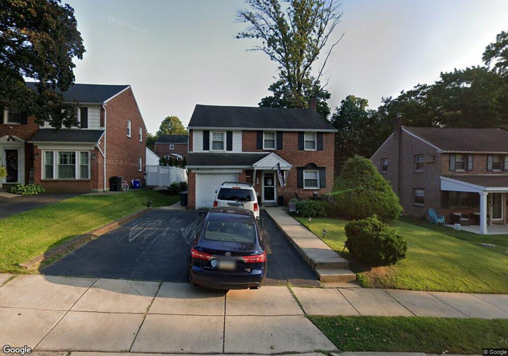
244 Flintlock Rd Drexel Hill, PA 19026
Estimated Value: $470,794 - $540,000
4
Beds
2
Baths
1,702
Sq Ft
$302/Sq Ft
Est. Value
About This Home
This home is located at 244 Flintlock Rd, Drexel Hill, PA 19026 and is currently estimated at $513,449, approximately $301 per square foot. 244 Flintlock Rd is a home located in Delaware County with nearby schools including Manoa Elementary School, Haverford Middle School, and Haverford Senior High School.
Ownership History
Date
Name
Owned For
Owner Type
Purchase Details
Closed on
Oct 27, 1995
Sold by
Price Joseph J and Price Joanmarie M
Bought by
Fredericks Michael P and Reavy Erin E
Current Estimated Value
Home Financials for this Owner
Home Financials are based on the most recent Mortgage that was taken out on this home.
Original Mortgage
$134,000
Outstanding Balance
$1,871
Interest Rate
7.58%
Estimated Equity
$511,578
Create a Home Valuation Report for This Property
The Home Valuation Report is an in-depth analysis detailing your home's value as well as a comparison with similar homes in the area
Home Values in the Area
Average Home Value in this Area
Purchase History
| Date | Buyer | Sale Price | Title Company |
|---|---|---|---|
| Fredericks Michael P | $144,500 | -- |
Source: Public Records
Mortgage History
| Date | Status | Borrower | Loan Amount |
|---|---|---|---|
| Open | Fredericks Michael P | $134,000 |
Source: Public Records
Tax History
| Year | Tax Paid | Tax Assessment Tax Assessment Total Assessment is a certain percentage of the fair market value that is determined by local assessors to be the total taxable value of land and additions on the property. | Land | Improvement |
|---|---|---|---|---|
| 2025 | $7,525 | $292,660 | $94,060 | $198,600 |
| 2024 | $7,525 | $292,660 | $94,060 | $198,600 |
| 2023 | $7,311 | $292,660 | $94,060 | $198,600 |
| 2022 | $7,140 | $292,660 | $94,060 | $198,600 |
| 2021 | $11,633 | $292,660 | $94,060 | $198,600 |
| 2020 | $6,540 | $140,710 | $51,250 | $89,460 |
| 2019 | $6,419 | $140,710 | $51,250 | $89,460 |
| 2018 | $6,309 | $140,710 | $0 | $0 |
| 2017 | $6,176 | $140,710 | $0 | $0 |
| 2016 | $772 | $140,710 | $0 | $0 |
| 2015 | $772 | $140,710 | $0 | $0 |
| 2014 | $772 | $140,710 | $0 | $0 |
Source: Public Records
Map
Nearby Homes
- 200 Warrior Rd
- 114 Pilgrim Ln
- 505 Glendale Rd
- 463 Foulke Ln
- 68 Pilgrim Ln
- 1204 Ellston Rd
- 204 N Belfield Ave
- 400 Glendale Rd Unit D33
- 400 Glendale Rd Unit A 54
- 400 Glendale Rd Unit G33
- 400 Glendale Rd Unit J13
- 412 N Rolling Rd
- 831 Stanbridge Rd
- 504 S Central Blvd
- 113 James Dr
- 4928 State Rd
- 1116 Blythe Ave
- 905 Addingham Ave
- 908 Roberts Ave
- 824 Collenbrook Ave
- 248 Flintlock Rd
- 240 Flintlock Rd
- 236 Flintlock Rd
- 245 Signal Rd
- 252 Flintlock Rd
- 249 Signal Rd
- 241 Signal Rd
- 232 Flintlock Rd
- 245 Flintlock Rd
- 249 Flintlock Rd
- 237 Signal Rd
- 241 Flintlock Rd
- 253 Flintlock Rd
- 237 Flintlock Rd
- 228 Flintlock Rd
- 233 Signal Rd
- 257 Flintlock Rd
- 233 Flintlock Rd
- 1376 Dermond Rd
- 1380 Dermond Rd
Your Personal Tour Guide
Ask me questions while you tour the home.