Estimated Value: $804,675 - $954,000
Studio
--
Bath
2,018
Sq Ft
$431/Sq Ft
Est. Value
About This Home
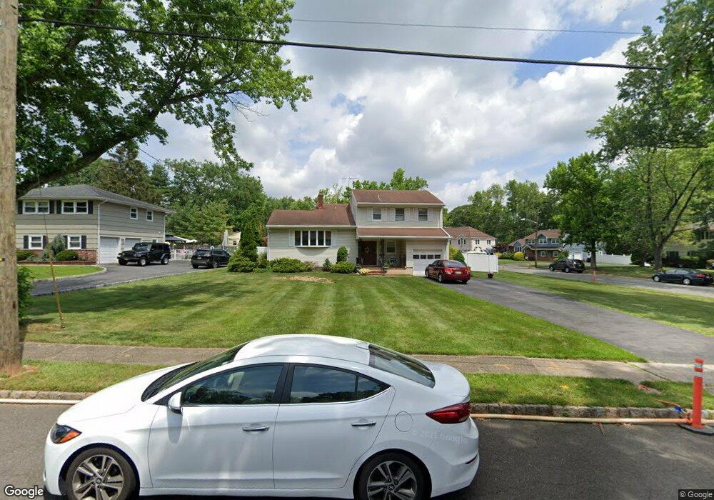
This home is located at 244 Laurel Ln, Clark, NJ 07066 and is currently estimated at $869,169, approximately $430 per square foot. 244 Laurel Ln is a home located in Union County with nearby schools including Frank K. Hehnly Elementary School, Carl H. Kumpf Middle School, and Arthur L. Johnson High School.
Ownership History
Date
Name
Owned For
Owner Type
Purchase Details
Closed on
Oct 25, 2005
Sold by
Brill Maria Mirto
Bought by
Marconi Robert and Marconi Sheryl
Current Estimated Value
Home Financials for this Owner
Home Financials are based on the most recent Mortgage that was taken out on this home.
Original Mortgage
$150,000
Outstanding Balance
$81,634
Interest Rate
5.93%
Mortgage Type
New Conventional
Estimated Equity
$787,535
Create a Home Valuation Report for This Property
The Home Valuation Report is an in-depth analysis detailing your home's value as well as a comparison with similar homes in the area
Home Values in the Area
Average Home Value in this Area
Purchase History
We collect this data history from publicly available records. To have your information removed, we recommend requesting removal directly through your county’s website.
| Date | Buyer | Sale Price | Title Company |
|---|---|---|---|
| Marconi Robert | $530,000 | -- |
Source: Public Records
Mortgage History
We collect this data history from publicly available records. To have your information removed, we recommend requesting removal directly through your county’s website.
| Date | Status | Borrower | Loan Amount |
|---|---|---|---|
| Open | Marconi Robert | $150,000 |
Source: Public Records
Tax History
| Year | Tax Paid | Tax Assessment Tax Assessment Total Assessment is a certain percentage of the fair market value that is determined by local assessors to be the total taxable value of land and additions on the property. | Land | Improvement |
|---|---|---|---|---|
| 2025 | $13,924 | $628,900 | $298,700 | $330,200 |
| 2024 | $13,716 | $628,900 | $298,700 | $330,200 |
| 2023 | $13,716 | $628,900 | $298,700 | $330,200 |
| 2022 | $13,320 | $628,900 | $298,700 | $330,200 |
| 2021 | $12,597 | $141,700 | $52,500 | $89,200 |
| 2020 | $12,392 | $141,700 | $52,500 | $89,200 |
| 2019 | $12,267 | $141,700 | $52,500 | $89,200 |
| 2018 | $12,120 | $141,700 | $52,500 | $89,200 |
| 2017 | $11,925 | $141,700 | $52,500 | $89,200 |
| 2016 | $11,486 | $141,700 | $52,500 | $89,200 |
| 2015 | $11,370 | $141,700 | $52,500 | $89,200 |
| 2014 | $11,131 | $141,700 | $52,500 | $89,200 |
Source: Public Records
Map
Nearby Homes
- 372 Willow Way
- 212 Oxford Rd
- 110 Normandy Rd
- 70 Oxford Rd
- 196 W Grant Ave
- 213 Normandy Rd
- 74 Overbrook Dr
- 184 Stonehenge Terrace
- 1168 Lake Ave Unit 6
- 10 Harvey Ct
- 4 Visco Dr
- 47 Harvey Ct
- 1 Sandalwood Dr
- 61 Cypress Dr
- 973 Ellis Pkwy
- 49 Hall Dr
- 48 Morningside Rd
- 17 Thelma Ct
- 24 Sandalwood Dr
- 41 Wareham Ct Unit W41
- 250 Laurel Ln
- 21 Wheatsheaf Rd
- 36 Wheatsheaf Rd
- 258 Laurel Ln
- 44 Wheatsheaf Rd
- 243 Laurel Ln
- 249 Laurel Ln
- 28 Wheatsheaf Rd
- 52 Wheatsheaf Rd
- 22 Wheatsheaf Rd
- 264 Laurel Ln
- 273 Oak Ridge Rd
- 257 Laurel Ln
- 65 Wheatsheaf Rd
- 265 Oak Ridge Rd
- 45 Brookside Terrace
- 39 Brookside Terrace
- 270 Laurel Ln
- 265 Laurel Ln
- 51 Brookside Terrace
Your Personal Tour Guide
Ask me questions while you tour the home.