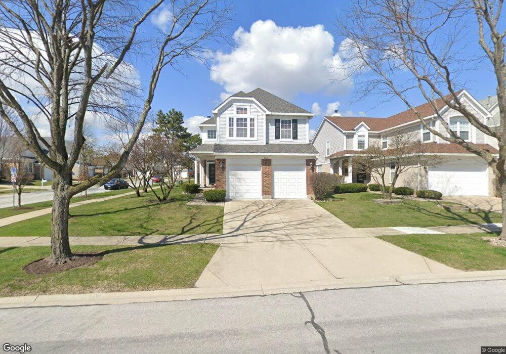
2440 Pinecrest Ln Westchester, IL 60154
Estimated Value: $500,000 - $519,000
3
Beds
3
Baths
2,235
Sq Ft
$228/Sq Ft
Est. Value
About This Home
This home is located at 2440 Pinecrest Ln, Westchester, IL 60154 and is currently estimated at $509,260, approximately $227 per square foot. 2440 Pinecrest Ln is a home located in Cook County with nearby schools including Hillside Elementary School, Proviso West High School, and Immanuel Christian Academy.
Ownership History
Date
Name
Owned For
Owner Type
Purchase Details
Closed on
Aug 28, 1997
Sold by
Pinnacle Corp
Bought by
Dorado Frank D and Dorado Arminda R
Current Estimated Value
Home Financials for this Owner
Home Financials are based on the most recent Mortgage that was taken out on this home.
Original Mortgage
$200,000
Outstanding Balance
$25,630
Interest Rate
7.25%
Estimated Equity
$483,630
Create a Home Valuation Report for This Property
The Home Valuation Report is an in-depth analysis detailing your home's value as well as a comparison with similar homes in the area
Home Values in the Area
Average Home Value in this Area
Purchase History
| Date | Buyer | Sale Price | Title Company |
|---|---|---|---|
| Dorado Frank D | $218,666 | -- |
Source: Public Records
Mortgage History
| Date | Status | Borrower | Loan Amount |
|---|---|---|---|
| Open | Dorado Frank D | $200,000 |
Source: Public Records
Tax History
| Year | Tax Paid | Tax Assessment Tax Assessment Total Assessment is a certain percentage of the fair market value that is determined by local assessors to be the total taxable value of land and additions on the property. | Land | Improvement |
|---|---|---|---|---|
| 2025 | $9,792 | $45,000 | $9,618 | $35,382 |
| 2024 | $9,792 | $45,000 | $9,618 | $35,382 |
| 2023 | $7,737 | $45,000 | $9,618 | $35,382 |
| 2022 | $7,737 | $34,472 | $7,794 | $26,678 |
| 2021 | $7,483 | $34,470 | $7,793 | $26,677 |
| 2020 | $7,474 | $34,470 | $7,793 | $26,677 |
| 2019 | $8,381 | $38,867 | $7,130 | $31,737 |
| 2018 | $8,259 | $38,867 | $7,130 | $31,737 |
| 2017 | $8,855 | $41,616 | $7,130 | $34,486 |
| 2016 | $8,094 | $35,164 | $6,467 | $28,697 |
| 2015 | $7,913 | $35,164 | $6,467 | $28,697 |
| 2014 | $8,740 | $39,121 | $6,467 | $32,654 |
| 2013 | $6,772 | $33,511 | $6,467 | $27,044 |
Source: Public Records
Map
Nearby Homes
- 2418 W Martindale Dr
- 2601 Burton Dr
- 11460 Prescott Ln
- 11438 Ashley Woods Dr
- 11466 Ashley Woods Dr
- 2612 Ashley Woods Dr
- 28 Queens Ct Unit Q28
- 10913 Martindale Dr
- 10909 Martindale Dr
- 10845 Claridge Ave
- 2828 Ashton Ct
- 10850 Claridge Ave Unit 2
- 10842 Claridge Ave
- 11138 Shaw St
- 11053 Mandel Ave
- 3057 Ashton Ct
- 1624 Boeger Ave
- 1943 Mayfair Ave
- 37 Sheffield Ln
- 10610 Essex St
- 2436 Pinecrest Ln
- 2432 Pinecrest Ln
- 2441 Meadowbrook Ln
- 2437 Meadowbrook Ln
- 2428 Pinecrest Ln
- 2433 Meadowbrook Ln
- 11237 Summerdale St
- 11241 Summerdale St
- 11233 Summerdale St
- 11245 Summerdale St
- 2441 Pinecrest Ln
- 2429 Meadowbrook Ln
- 2437 Pinecrest Ln
- 2424 Pinecrest Ln
- 11229 Summerdale St
- 2433 Pinecrest Ln
- 11249 Summerdale St
- 2425 Meadowbrook Ln
- 2429 Pinecrest Ln
- 11225 Summerdale St
Your Personal Tour Guide
Ask me questions while you tour the home.