Estimated Value: $316,854 - $688,000
Studio
--
Bath
--
Sq Ft
6,360
Sq Ft Lot
About This Home
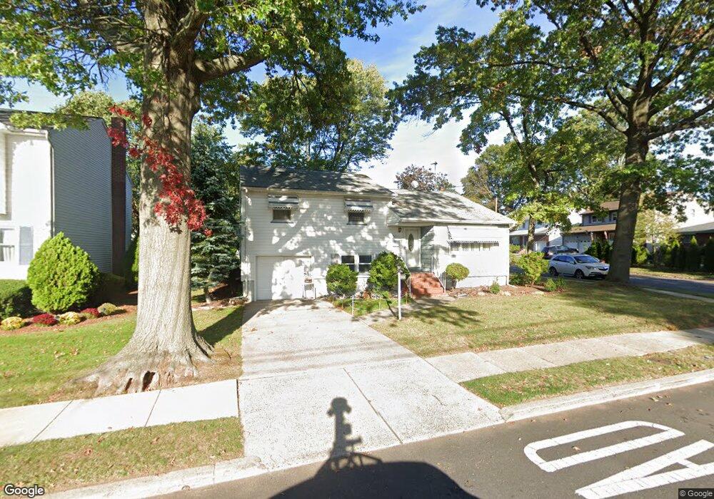
This home is located at 2443 Poplar St, Union, NJ 07083 and is currently estimated at $577,714. 2443 Poplar St is a home located in Union County with nearby schools including Battle Hill Elementary School, Burnet Middle School, and Union High School.
Ownership History
Date
Name
Owned For
Owner Type
Purchase Details
Closed on
Jul 15, 2010
Sold by
Jp Morgan Chase Bank National Associatio
Bought by
Millien Elie and Millien Marie
Current Estimated Value
Home Financials for this Owner
Home Financials are based on the most recent Mortgage that was taken out on this home.
Original Mortgage
$194,600
Interest Rate
4.17%
Mortgage Type
New Conventional
Purchase Details
Closed on
Apr 13, 2010
Sold by
Ahmed Mumtaz and Alfieri Keith
Bought by
Deutsche Bank National Trust Company
Purchase Details
Closed on
Sep 14, 1999
Sold by
Mair Warren C
Bought by
Perez Gonzalo and Perez Rosa
Home Financials for this Owner
Home Financials are based on the most recent Mortgage that was taken out on this home.
Original Mortgage
$160,000
Interest Rate
7.68%
Mortgage Type
Purchase Money Mortgage
Create a Home Valuation Report for This Property
The Home Valuation Report is an in-depth analysis detailing your home's value as well as a comparison with similar homes in the area
Home Values in the Area
Average Home Value in this Area
Purchase History
| Date | Buyer | Sale Price | Title Company |
|---|---|---|---|
| Millien Elie | $278,000 | None Available | |
| Deutsche Bank National Trust Company | -- | None Available | |
| Perez Gonzalo | $200,000 | -- |
Source: Public Records
Mortgage History
| Date | Status | Borrower | Loan Amount |
|---|---|---|---|
| Previous Owner | Millien Elie | $194,600 | |
| Previous Owner | Perez Gonzalo | $160,000 |
Source: Public Records
Tax History
| Year | Tax Paid | Tax Assessment Tax Assessment Total Assessment is a certain percentage of the fair market value that is determined by local assessors to be the total taxable value of land and additions on the property. | Land | Improvement |
|---|---|---|---|---|
| 2025 | $11,578 | $51,800 | $21,800 | $30,000 |
| 2024 | $11,225 | $51,800 | $21,800 | $30,000 |
Source: Public Records
Map
Nearby Homes
- 2462 Woodside Rd
- 2442 Terrill Rd
- 933 Douglas Terrace
- 909 Garden St
- 2469 Macarthur Dr
- 1016 Gifford Ct
- 2636 Frederick Terrace
- 5 Bashford Ave Unit 5
- 832 Dewey St
- 946 Moessner Ave
- 2705 Andrea Rd
- 960 Moessner Ave
- 968 Moessner Ave
- 5 Sadie Cir Unit 5201
- 3 Sadie Cir Unit 3104
- 1066 W Chestnut St
- 823 Pinewood Rd
- 452 Tournament Dr Unit 7
- 2659 Hawthorne Ave
- 482 Tournament Dr Unit 8
- 2447 Poplar St
- 862 Peach Tree Rd
- 853 Sheridan St
- 866 Peach Tree Rd
- 841 Sheridan St
- 2433 Poplar St
- 859 Peach Tree Rd
- 859 Sheridan St
- 863 Peach Tree Rd
- 2438 Poplar St
- 870 Peach Tree Rd
- 2505 Poplar St
- 837 Sheridan St
- 867 Peach Tree Rd
- 2432 Poplar St
- 863 Sheridan St
- 863 Sheridan St Unit 1
- 2502 Poplar St
- 874 Peach Tree Rd
- 871 Peach Tree Rd
Your Personal Tour Guide
Ask me questions while you tour the home.