Estimated Value: $600,000 - $764,000
5
Beds
5
Baths
4,738
Sq Ft
$144/Sq Ft
Est. Value
About This Home
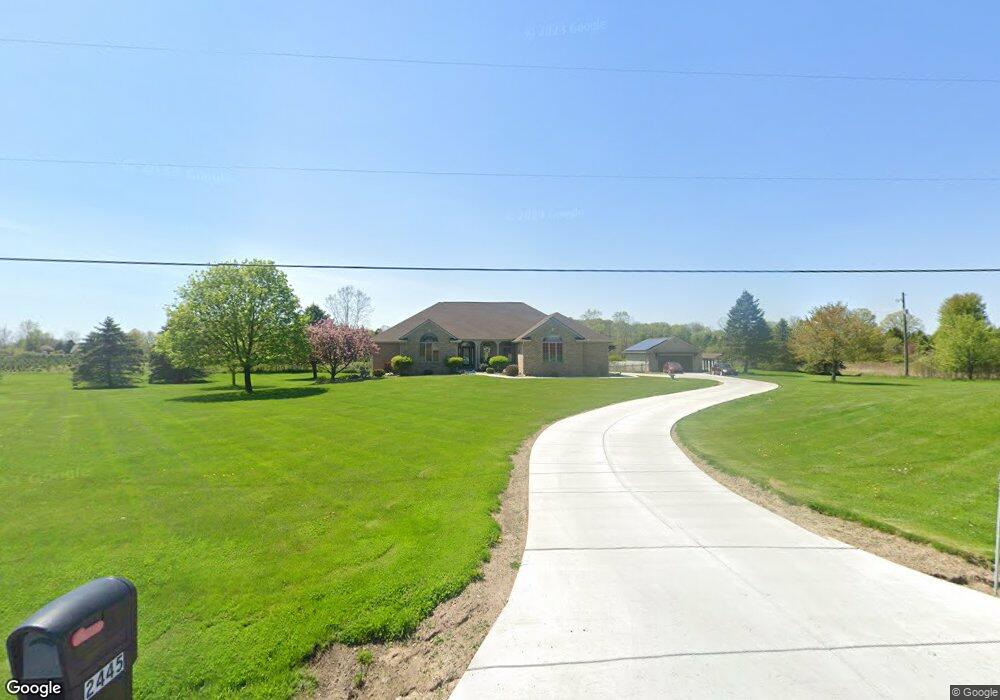
This home is located at 2445 Dobie Rd, Mason, MI 48854 and is currently estimated at $683,247, approximately $144 per square foot. 2445 Dobie Rd is a home located in Ingham County with nearby schools including Mason High School.
Ownership History
Date
Name
Owned For
Owner Type
Purchase Details
Closed on
Jun 26, 2023
Sold by
Billingslea Christopher R and Billingslea Tameka S
Bought by
Christopher And Tameka S Billingslea Living T
Current Estimated Value
Purchase Details
Closed on
Aug 30, 2002
Sold by
Pinehill Estates Llc
Bought by
Geers David and Geers Patricia
Purchase Details
Closed on
Jun 19, 1998
Sold by
Schmidgall Raymond S
Bought by
Geers David and Geers Patricia
Purchase Details
Closed on
Jan 31, 1989
Sold by
Schmidgall R
Create a Home Valuation Report for This Property
The Home Valuation Report is an in-depth analysis detailing your home's value as well as a comparison with similar homes in the area
Home Values in the Area
Average Home Value in this Area
Purchase History
| Date | Buyer | Sale Price | Title Company |
|---|---|---|---|
| Christopher And Tameka S Billingslea Living T | -- | None Listed On Document | |
| Geers David | $57,500 | -- | |
| Geers David | $44,000 | -- | |
| -- | $45,000 | -- |
Source: Public Records
Tax History Compared to Growth
Tax History
| Year | Tax Paid | Tax Assessment Tax Assessment Total Assessment is a certain percentage of the fair market value that is determined by local assessors to be the total taxable value of land and additions on the property. | Land | Improvement |
|---|---|---|---|---|
| 2025 | $9,888 | $348,400 | $26,500 | $321,900 |
| 2024 | $67 | $359,000 | $26,500 | $332,500 |
| 2023 | $9,169 | $315,800 | $24,500 | $291,300 |
| 2022 | $8,718 | $284,000 | $24,500 | $259,500 |
| 2021 | $8,568 | $273,500 | $28,300 | $245,200 |
| 2020 | $8,415 | $281,700 | $28,300 | $253,400 |
| 2019 | $8,119 | $265,600 | $28,300 | $237,300 |
| 2018 | $7,944 | $257,000 | $28,300 | $228,700 |
| 2017 | $7,554 | $257,000 | $28,300 | $228,700 |
| 2016 | -- | $266,500 | $28,300 | $238,200 |
| 2015 | -- | $234,700 | $56,560 | $178,140 |
| 2014 | -- | $216,800 | $53,560 | $163,240 |
Source: Public Records
Map
Nearby Homes
- 1234 Lamb Rd
- 2004 Timberview Dr
- 1572 Wenonah Dr
- 3588 Autumnwood Ln
- 3624 W Arbutus Dr
- 3660 Powderhorn Dr
- 2073 Birch Bluff Dr
- 2083 Fox Hollow Dr
- 2024 Belwood Dr
- 3740 Cavalier Dr Unit 2
- 3826 Pine Knoll Dr
- 1136 Bonanza Dr
- 12 Atrium Dr
- 3720 Crane Cir
- 3921 Dobie Rd
- 3729 Crane Cir
- 3732 Crane Cir
- 3738 Crane Cir
- 2740 Lupine Dr
- 3735 Crane Cir
- 2487 Dobie Rd
- 2460 Dobie Rd
- 2434 Dobie Rd
- 2410 Dobie Rd
- 1701 Willoughby Rd
- 2576 Dobie Rd
- 2367 Dobie Rd
- 2360 Dobie Rd
- 2348 Dobie Rd
- 2550 Dobie Rd
- 2352 Dobie Rd
- 1888 Willoughby Rd
- 1831 Willoughby Rd
- 1637 Willoughby Rd
- 2316 Dobie Rd
- 2600 Dobie Rd
- 2370 Dobie Rd
- 1636 Willoughby Rd
- 1910 Willoughby Rd
- 1601 Willoughby Rd