
Seller's Agent in 2025
John Boch
Cutler Real Estate
(614) 332-1916
1 in this area
55 Total Sales
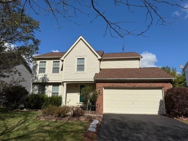


Amazing Opportunity in Kensington Place!
Don't miss this spacious 2-story home featuring an open floor plan perfect for modern living. With 4 bedrooms and 2.5 baths, there's plenty of room for family, guests, or a home office setup. The master suite includes a generously sized bathroom, offering a private retreat. Enjoy outdoor living in the fenced backyard complete with a patio—ideal for entertaining or relaxing. A large tool shed provides ample storage for all your needs. The basement is ready to be finished—offering a blank canvas for your dream space, whether it's a rec room, home gym, or additional living area. Conveniently located close to schools, shopping, and freeway access, this home checks all the boxes. Call today to schedule your showing and see how this could be your next home!
| Date | Type | Sale Price | Title Company |
|---|---|---|---|
| Fiduciary Deed | $335,000 | Northwest Title | |
| Deed | $178,000 | -- | |
| Deed | $600,000 | -- |
| Date | Status | Loan Amount | Loan Type |
|---|---|---|---|
| Open | $201,000 | New Conventional | |
| Previous Owner | $169,100 | New Conventional |
| Date | Event | Price | List to Sale | Price per Sq Ft |
|---|---|---|---|---|
| 11/06/2025 11/06/25 | Sold | $335,000 | +3.1% | $151 / Sq Ft |
| 10/15/2025 10/15/25 | For Sale | $324,900 | -- | $147 / Sq Ft |
| Year | Tax Paid | Tax Assessment Tax Assessment Total Assessment is a certain percentage of the fair market value that is determined by local assessors to be the total taxable value of land and additions on the property. | Land | Improvement |
|---|---|---|---|---|
| 2024 | $5,470 | $113,060 | $19,780 | $93,280 |
| 2023 | $5,348 | $113,060 | $19,780 | $93,280 |
| 2022 | $4,368 | $80,150 | $14,700 | $65,450 |
| 2021 | $4,465 | $80,150 | $14,700 | $65,450 |
| 2020 | $4,516 | $80,150 | $14,700 | $65,450 |
| 2019 | $4,152 | $66,780 | $12,250 | $54,530 |
| 2018 | $4,209 | $66,780 | $12,250 | $54,530 |
| 2017 | $3,821 | $60,030 | $10,290 | $49,740 |
| 2016 | $3,453 | $60,030 | $10,290 | $49,740 |
| 2015 | $3,472 | $60,030 | $10,290 | $49,740 |
| 2014 | $3,527 | $60,030 | $10,290 | $49,740 |
| 2013 | $3,547 | $60,030 | $10,290 | $49,740 |
Seller's Agent in 2025
John Boch
Cutler Real Estate
(614) 332-1916
1 in this area
55 Total Sales
Buyer's Agent in 2025
Ryan Ruehle
EXP Realty, LLC
(614) 310-6077
71 in this area
1,475 Total Sales
Buyer Co-Listing Agent in 2025
Justin Spain
EXP Realty, LLC
(419) 235-2862
2 in this area
28 Total Sales
Source: Columbus and Central Ohio Regional MLS
MLS Number: 225039160
APN: 519-441-06-012-000
Disclaimer: Certain information contained herein is derived from information provided by parties other than Homes.com. All information provided is deemed reliable, but is not guaranteed to be accurate and should be independently verified.
![]() IDX information is provided exclusively for personal, non-commercial use, and may not be used for any purpose other than to identify prospective properties consumers may be interested in purchasing.
IDX information is provided exclusively for personal, non-commercial use, and may not be used for any purpose other than to identify prospective properties consumers may be interested in purchasing.
Information is deemed reliable but not guaranteed.
Ask me questions while you tour the home.