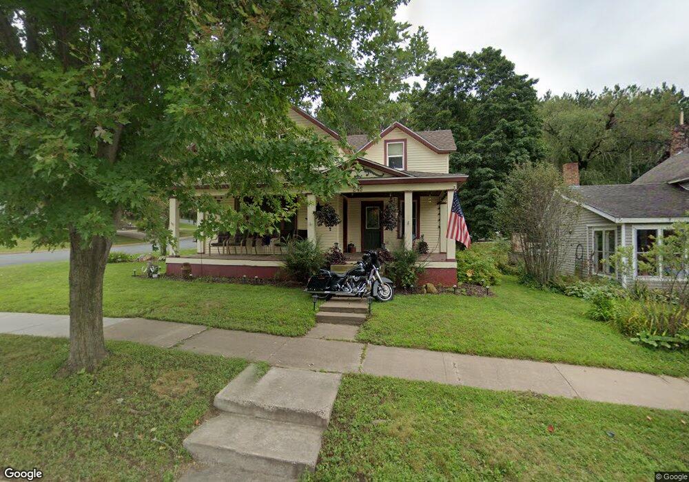
245 Maple St Glenwood City, WI 54013
Glenwood NeighborhoodEstimated Value: $207,000 - $269,000
4
Beds
3
Baths
--
Sq Ft
6,534
Sq Ft Lot
About This Home
This home is located at 245 Maple St, Glenwood City, WI 54013 and is currently estimated at $238,866. 245 Maple St is a home located in St. Croix County with nearby schools including Glenwood City Elementary School, Glenwood City Middle School, and Glenwood City High School.
Ownership History
Date
Name
Owned For
Owner Type
Purchase Details
Closed on
Feb 19, 2009
Sold by
Kopacz Thomas H and Kopacz Theresa R
Bought by
Anderson Jennifer M
Current Estimated Value
Home Financials for this Owner
Home Financials are based on the most recent Mortgage that was taken out on this home.
Original Mortgage
$89,900
Outstanding Balance
$56,949
Interest Rate
5.14%
Mortgage Type
Purchase Money Mortgage
Estimated Equity
$181,917
Purchase Details
Closed on
Nov 7, 2008
Sold by
Homecomings Financial Real Estate Holdin
Bought by
Kopacz Thomas H and Kopacz Theresa R
Purchase Details
Closed on
Mar 25, 2008
Sold by
Bapp Jerry
Bought by
Residential Funding Co Llc
Create a Home Valuation Report for This Property
The Home Valuation Report is an in-depth analysis detailing your home's value as well as a comparison with similar homes in the area
Home Values in the Area
Average Home Value in this Area
Purchase History
| Date | Buyer | Sale Price | Title Company |
|---|---|---|---|
| Anderson Jennifer M | $85,000 | None Available | |
| Kopacz Thomas H | $57,800 | Servicelink | |
| Homecomings Financial Real Estate Holdin | -- | None Available | |
| Residential Funding Co Llc | -- | None Available |
Source: Public Records
Mortgage History
| Date | Status | Borrower | Loan Amount |
|---|---|---|---|
| Open | Anderson Jennifer M | $89,900 |
Source: Public Records
Tax History Compared to Growth
Tax History
| Year | Tax Paid | Tax Assessment Tax Assessment Total Assessment is a certain percentage of the fair market value that is determined by local assessors to be the total taxable value of land and additions on the property. | Land | Improvement |
|---|---|---|---|---|
| 2024 | $29 | $200,600 | $25,000 | $175,600 |
| 2023 | $2,866 | $200,600 | $25,000 | $175,600 |
| 2022 | $2,217 | $200,600 | $25,000 | $175,600 |
| 2021 | $2,355 | $110,300 | $8,800 | $101,500 |
| 2020 | $2,227 | $110,300 | $8,800 | $101,500 |
| 2019 | $2,228 | $110,300 | $8,800 | $101,500 |
| 2018 | $2,201 | $110,300 | $8,800 | $101,500 |
| 2017 | $2,159 | $110,300 | $8,800 | $101,500 |
| 2016 | $2,159 | $110,300 | $8,800 | $101,500 |
| 2015 | $2,123 | $110,300 | $8,800 | $101,500 |
| 2014 | $2,128 | $110,300 | $8,800 | $101,500 |
| 2013 | $2,201 | $110,300 | $8,800 | $101,500 |
Source: Public Records
Map
Nearby Homes
- 201 -203 Lj Estates
- 417 Maple St
- 323 1/2 1st St
- 509 3rd St
- 143 Tiffany Creek Rd
- 1110 Park Dr
- 270 Magnolia Dr
- 1038 Syme Ave Unit C
- 3013 County Road Dd
- 1620 County Road X
- 1342 280th St
- XXX Hwy 64
- 1350 County Road D Lot 4
- 0 260th St
- 140th Avenue
- 260th Street
- 0 140th Ave
- Lot 2 1240th Ave
- Lot 1 1240th Ave
- 1920 Cty Rd P