Estimated Value: $66,000 - $213,000
--
Bed
--
Bath
1,120
Sq Ft
$107/Sq Ft
Est. Value
About This Home
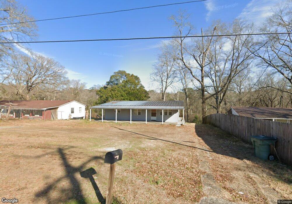
This home is located at 245 Matthews Ave, Ozark, AL 36360 and is currently estimated at $119,441, approximately $106 per square foot. 245 Matthews Ave is a home located in Dale County with nearby schools including Lisenby Primary School, Mixon Intermediate School, and D. A. Smith Middle School.
Ownership History
Date
Name
Owned For
Owner Type
Purchase Details
Closed on
May 21, 2024
Sold by
Crooks Shane and Crooks Richard Shane
Bought by
Hardwick William Augustus and Hardwick William Edward
Current Estimated Value
Purchase Details
Closed on
Jul 17, 2020
Sold by
Clark Franz
Bought by
Crooks Richard Shane
Purchase Details
Closed on
Dec 9, 2011
Sold by
Baird Wanda L
Bought by
Baird Wanda L and Clark Franz
Purchase Details
Closed on
Sep 20, 2010
Sold by
Tucker Amy
Bought by
Baird Wanda Lee
Create a Home Valuation Report for This Property
The Home Valuation Report is an in-depth analysis detailing your home's value as well as a comparison with similar homes in the area
Home Values in the Area
Average Home Value in this Area
Purchase History
| Date | Buyer | Sale Price | Title Company |
|---|---|---|---|
| Hardwick William Augustus | $400,000 | None Listed On Document | |
| Hardwick William Augustus | $400,000 | None Listed On Document | |
| Crooks Richard Shane | -- | None Available | |
| Baird Wanda L | -- | -- | |
| Baird Wanda Lee | -- | -- |
Source: Public Records
Tax History Compared to Growth
Tax History
| Year | Tax Paid | Tax Assessment Tax Assessment Total Assessment is a certain percentage of the fair market value that is determined by local assessors to be the total taxable value of land and additions on the property. | Land | Improvement |
|---|---|---|---|---|
| 2024 | $611 | $12,100 | $520 | $11,580 |
| 2023 | $611 | $10,500 | $520 | $9,980 |
| 2022 | $432 | $8,560 | $8,560 | $0 |
| 2021 | $402 | $7,960 | $520 | $7,440 |
| 2020 | $147 | $3,980 | $260 | $3,720 |
| 2019 | $147 | $3,980 | $260 | $3,720 |
| 2018 | $135 | $3,700 | $260 | $3,440 |
| 2017 | $187 | $3,700 | $260 | $3,440 |
| 2016 | $135 | $3,700 | $260 | $3,440 |
| 2015 | $155 | $4,140 | $260 | $3,880 |
| 2014 | $151 | $4,060 | $260 | $3,800 |
| 2013 | $150 | $4,060 | $260 | $3,800 |
Source: Public Records
Map
Nearby Homes
- 203 Ozark Ave
- 590 Bingham Ave
- 727 E Eufaula St
- 166 Garner Dr
- 236 Choctaw Ave
- 840 Newton Ave
- 496 E Broad St
- 0 Briar Cliff Dr Lot 1 Blk D
- 332 E Broad St
- 385 E Broad St
- 0 Briar Cliff Rd Lot 5 Bk E
- 252 Del Rio Terrace
- 729 Pine Ave
- 00 Lot 9 & 10 Sandy Hill
- 0 Del Rio Terrace
- 877 Bermuda St
- 152 Short Pine Ave
- 0 Pierces Station 14a Unit 204870
- 0 Pierces Station 15a Unit 204869
- 0 Pierces Station 18a Unit 204868
- 259 Matthews Ave
- 227 Matthews Ave
- 457 Matthews Ave
- 273 Matthews Ave
- 291 Matthews Ave
- 339 Matthews Ave
- 330 Matthews Ave
- 0 Herring Ave Unit 519193
- 0 Herring Ave Unit 518932
- 656 James St
- 200C Edna Dr
- TBA James St
- 218 Hospital Ave
- 674 James St
- 318 James St
- 166 James St
- 170 James St
- 144 James St
- 214 Hospital Ave
- CORNER Herring Ave & James St