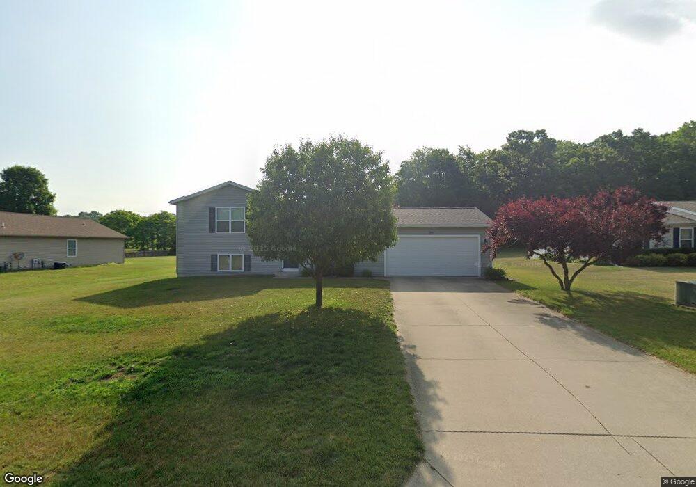
245 Zak Rd Plainwell, MI 49080
Estimated Value: $294,199 - $311,000
3
Beds
2
Baths
1,260
Sq Ft
$239/Sq Ft
Est. Value
About This Home
This home is located at 245 Zak Rd, Plainwell, MI 49080 and is currently estimated at $300,550, approximately $238 per square foot. 245 Zak Rd is a home located in Allegan County with nearby schools including Otsego High School, Otsego Christian Academy, and St. Margaret School.
Ownership History
Date
Name
Owned For
Owner Type
Purchase Details
Closed on
May 23, 2008
Sold by
Thomas Termeer Builders Inc
Bought by
Redfield Troy C and Redfield Erin M
Current Estimated Value
Home Financials for this Owner
Home Financials are based on the most recent Mortgage that was taken out on this home.
Original Mortgage
$135,908
Outstanding Balance
$86,295
Interest Rate
5.93%
Mortgage Type
FHA
Estimated Equity
$214,255
Create a Home Valuation Report for This Property
The Home Valuation Report is an in-depth analysis detailing your home's value as well as a comparison with similar homes in the area
Home Values in the Area
Average Home Value in this Area
Purchase History
| Date | Buyer | Sale Price | Title Company |
|---|---|---|---|
| Redfield Troy C | $137,000 | Devon Title Agency | |
| Thomas Termeer Builders Inc | -- | Devon Title Agency |
Source: Public Records
Mortgage History
| Date | Status | Borrower | Loan Amount |
|---|---|---|---|
| Open | Thomas Termeer Builders Inc | $135,908 |
Source: Public Records
Tax History Compared to Growth
Tax History
| Year | Tax Paid | Tax Assessment Tax Assessment Total Assessment is a certain percentage of the fair market value that is determined by local assessors to be the total taxable value of land and additions on the property. | Land | Improvement |
|---|---|---|---|---|
| 2025 | $2,580 | $127,500 | $9,700 | $117,800 |
| 2024 | $2,147 | $124,100 | $6,900 | $117,200 |
| 2023 | $2,185 | $108,600 | $6,900 | $101,700 |
| 2022 | $2,147 | $93,500 | $6,600 | $86,900 |
| 2021 | $2,029 | $87,000 | $5,400 | $81,600 |
| 2020 | $2,004 | $83,900 | $5,000 | $78,900 |
| 2019 | $1,939 | $78,700 | $4,100 | $74,600 |
| 2018 | $1,903 | $75,400 | $4,200 | $71,200 |
| 2017 | $0 | $71,200 | $4,200 | $67,000 |
| 2016 | $0 | $58,400 | $4,200 | $54,200 |
| 2015 | -- | $58,400 | $4,200 | $54,200 |
| 2014 | $1,830 | $63,100 | $4,200 | $58,900 |
| 2013 | $1,830 | $60,800 | $5,400 | $55,400 |
Source: Public Records
Map
Nearby Homes
- 323 13th St
- 355 12th St
- 1020 Barton St
- 390 12th St
- 909 Barton St
- 551 W Bridge St
- 426 W Bridge St
- 1056 Elmwood St
- V/L 11th St
- 805 Irving St
- 140 W 1st Ave
- 192 Dix St
- Integrity 1880 Plan at Southpointe Trails
- Integrity 1910 Plan at Southpointe Trails
- Integrity 1250 Plan at Southpointe Trails
- Integrity 1750 Plan at Southpointe Trails
- Integrity 2000 Plan at Southpointe Trails
- Elements 2100 Plan at Southpointe Trails
- Elements 2700 Plan at Southpointe Trails
- Integrity 1560 Plan at Southpointe Trails