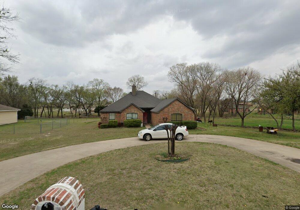
2451 Frances Ln Midlothian, TX 76065
Estimated Value: $328,471 - $347,000
3
Beds
2
Baths
1,856
Sq Ft
$182/Sq Ft
Est. Value
About This Home
This home is located at 2451 Frances Ln, Midlothian, TX 76065 and is currently estimated at $337,736, approximately $181 per square foot. 2451 Frances Ln is a home located in Ellis County with nearby schools including T E Baxter Elementary School and Walnut Grove Middle School.
Ownership History
Date
Name
Owned For
Owner Type
Purchase Details
Closed on
Oct 9, 2007
Sold by
Bank Of New York
Bought by
Moreno David and Moreno Claudia
Current Estimated Value
Home Financials for this Owner
Home Financials are based on the most recent Mortgage that was taken out on this home.
Original Mortgage
$124,900
Outstanding Balance
$79,073
Interest Rate
6.48%
Mortgage Type
New Conventional
Estimated Equity
$258,663
Purchase Details
Closed on
Apr 3, 2007
Sold by
Bryant Develoyn Darrell and Bryant Tamata Nicloe
Bought by
The Bank Of New York
Create a Home Valuation Report for This Property
The Home Valuation Report is an in-depth analysis detailing your home's value as well as a comparison with similar homes in the area
Home Values in the Area
Average Home Value in this Area
Purchase History
| Date | Buyer | Sale Price | Title Company |
|---|---|---|---|
| Moreno David | -- | None Available | |
| The Bank Of New York | $117,672 | None Available |
Source: Public Records
Mortgage History
| Date | Status | Borrower | Loan Amount |
|---|---|---|---|
| Open | Moreno David | $124,900 |
Source: Public Records
Tax History Compared to Growth
Tax History
| Year | Tax Paid | Tax Assessment Tax Assessment Total Assessment is a certain percentage of the fair market value that is determined by local assessors to be the total taxable value of land and additions on the property. | Land | Improvement |
|---|---|---|---|---|
| 2025 | $4,079 | $302,518 | $100,000 | $202,518 |
| 2024 | $4,079 | $293,658 | -- | -- |
| 2023 | $4,079 | $266,962 | $0 | $0 |
| 2022 | $5,437 | $242,693 | $0 | $0 |
| 2021 | $5,221 | $220,630 | $39,380 | $181,250 |
| 2020 | $5,205 | $206,910 | $37,500 | $169,410 |
| 2019 | $5,146 | $196,520 | $0 | $0 |
| 2018 | $4,872 | $184,430 | $30,000 | $154,430 |
| 2017 | $4,859 | $185,560 | $30,000 | $155,560 |
| 2016 | $4,417 | $165,940 | $30,000 | $135,940 |
| 2015 | $3,549 | $155,120 | $30,000 | $125,120 |
| 2014 | $3,549 | $151,610 | $0 | $0 |
Source: Public Records
Map
Nearby Homes
- 111 Kirk Rd
- 2814 Livestock Dr
- 2818 Livestock Dr
- 2830 Livestock Dr
- 2841 Livestock Dr
- 2825 Livestock Dr
- 2834 Livestock Dr
- 2845 Livestock Dr
- 2838 Livestock Dr
- 4210 Tea Olive Dr
- 4821 Azalea Way
- Lot 2 Tbd Ln
- Lot 3 Tbd Ln
- Lot 5 Tbd Ln
- 2846 Livestock Dr
- 246 Vineyard Ln
- Providence Plan at Redden Farms
- Sacramento Plan at Redden Farms
- Graham Plan at Redden Farms
- Phoenix Plan at Redden Farms