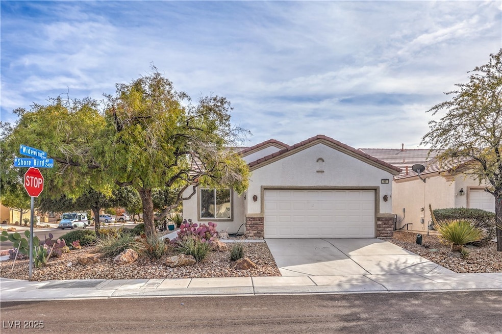


2451 Shore Bird Ave North Las Vegas, NV 89084
Aliante NeighborhoodEstimated payment $2,327/month
Highlights
- Golf Course Community
- Fitness Center
- Mountain View
- Country Club
- Active Adult
- Clubhouse
About This Home
Check out this beautiful and highly desirable Primrose model in the vibrant 55+ community of Sun City Aliante!! This home features 3 bedrooms and 2 full bathrooms, along with a large great room, kitchen with eating/breakfast nook adjacent, and a good sized dining area. The home is situated on a large corner lot with a fully fenced back yard. This home has been well kept and includes all appliances. Sun City Aliante features state-of-the-art fitness facilities, including tennis and Pickleball courts. An 18-hole golf course runs through the community. A modern casino/hotel complex featuring a 16-theater cineplex and a number of excellent dining locations are all within walking distance.
Home Details
Home Type
- Single Family
Est. Annual Taxes
- $1,863
Year Built
- Built in 2006
Lot Details
- 5,663 Sq Ft Lot
- North Facing Home
- Wrought Iron Fence
- Back Yard Fenced
- Desert Landscape
HOA Fees
Parking
- 2 Car Attached Garage
- Inside Entrance
- Garage Door Opener
Home Design
- Tile Roof
Interior Spaces
- 1,420 Sq Ft Home
- 1-Story Property
- Ceiling Fan
- Double Pane Windows
- Blinds
- Mountain Views
Kitchen
- Breakfast Area or Nook
- Gas Range
- Microwave
- Dishwasher
- Disposal
Flooring
- Carpet
- Tile
Bedrooms and Bathrooms
- 3 Bedrooms
Laundry
- Laundry Room
- Laundry on main level
- Dryer
- Washer
Schools
- Triggs Elementary School
- Saville Anthony Middle School
- Shadow Ridge High School
Utilities
- Central Heating and Cooling System
- Heating System Uses Gas
- Underground Utilities
- Above Ground Utilities
Additional Features
- Energy-Efficient Windows
- Covered Patio or Porch
Community Details
Overview
- Active Adult
- Association fees include management, ground maintenance, recreation facilities
- Sun City Association, Phone Number (702) 399-4273
- Sun City Aliante Phase 2 Subdivision
Amenities
- Clubhouse
- Recreation Room
Recreation
- Golf Course Community
- Country Club
- Tennis Courts
- Fitness Center
- Community Pool
- Community Spa
Map
Home Values in the Area
Average Home Value in this Area
Tax History
| Year | Tax Paid | Tax Assessment Tax Assessment Total Assessment is a certain percentage of the fair market value that is determined by local assessors to be the total taxable value of land and additions on the property. | Land | Improvement |
|---|---|---|---|---|
| 2025 | $1,863 | $96,877 | $28,000 | $68,877 |
| 2024 | $1,809 | $96,877 | $28,000 | $68,877 |
| 2023 | $1,809 | $95,103 | $30,100 | $65,003 |
| 2022 | $1,759 | $85,031 | $25,900 | $59,131 |
| 2021 | $1,709 | $79,298 | $23,100 | $56,198 |
| 2020 | $1,652 | $77,878 | $22,400 | $55,478 |
| 2019 | $1,604 | $74,893 | $20,300 | $54,593 |
| 2018 | $1,558 | $68,507 | $16,100 | $52,407 |
| 2017 | $2,202 | $66,106 | $14,000 | $52,106 |
| 2016 | $1,475 | $64,301 | $12,250 | $52,051 |
| 2015 | $1,515 | $51,851 | $9,800 | $42,051 |
| 2014 | $1,470 | $43,512 | $7,000 | $36,512 |
Property History
| Date | Event | Price | List to Sale | Price per Sq Ft |
|---|---|---|---|---|
| 12/01/2025 12/01/25 | For Sale | $385,000 | -- | $271 / Sq Ft |
Purchase History
| Date | Type | Sale Price | Title Company |
|---|---|---|---|
| Interfamily Deed Transfer | -- | None Available | |
| Bargain Sale Deed | $267,194 | Lawyers Title Of Nevada |
Mortgage History
| Date | Status | Loan Amount | Loan Type |
|---|---|---|---|
| Open | $74,694 | Fannie Mae Freddie Mac |
Source: Las Vegas REALTORS®
MLS Number: 2738413
APN: 124-17-615-145
Disclaimer: Certain information contained herein is derived from information provided by parties other than Homes.com. All information provided is deemed reliable, but is not guaranteed to be accurate and should be independently verified.
![]() The data relating to real estate for sale on this web site comes in part from the INTERNET DATA EXCHANGE Program of the Greater Las Vegas Association of REALTORS® MLS. Real estate listings held by brokerage firms other than this site owner are marked with the IDX logo. Information is deemed reliable but not guaranteed. Copyright 2025 of the Greater Las Vegas Association of REALTORS® MLS. All rights reserved.
The data relating to real estate for sale on this web site comes in part from the INTERNET DATA EXCHANGE Program of the Greater Las Vegas Association of REALTORS® MLS. Real estate listings held by brokerage firms other than this site owner are marked with the IDX logo. Information is deemed reliable but not guaranteed. Copyright 2025 of the Greater Las Vegas Association of REALTORS® MLS. All rights reserved.
- 7757 Coast Jay St
- 7744 Widewing Dr Unit 8
- 7824 Starthroat Ct
- 7749 Pine Warbler Way
- 2220 Carrier Dove Way
- 7713 Songster St
- 2421 Willow Wren Dr
- 2508 Mourning Warbler Ave
- 7945 Woodlark Ct
- 2404 Willow Wren Dr
- 7813 Homing Pigeon St
- 2320 Willow Wren Dr
- 7716 Homing Pigeon St
- 7905 Grey Teal St
- 1943 Marks River Place
- 7904 Broadwing Dr
- 1961 Colbert Cove Ct
- 7709 Island Rail Dr
- 7847 Skyler Falls Ln
- 7831 Nestor Creek Ln
- 7709 Island Rail Dr
- 7637 Fieldfare Dr
- 7628 Fieldfare Dr Unit n/a
- 7831 Nestor Creek Ln
- 3105 Kingbird Dr
- 7404 Shelduck St
- 7714 Duran Harbor Ln
- 3321 Kingbird Dr
- 7922 Crested Starling Ct
- 7410 Kingsley Cove Ln
- 3752 Andorian Ave
- 1721 Pamela Springs Ln
- 1693 Pamela Springs Ln
- 3823 Corellia Ave
- 8124 Chimney Bluff St
- 7089 N Aliante Pkwy
- 8208 Seven Falls St
- 7709 Markarian St
- 7404 Eggshell Dr
- 4133 Venus Falls Ave
