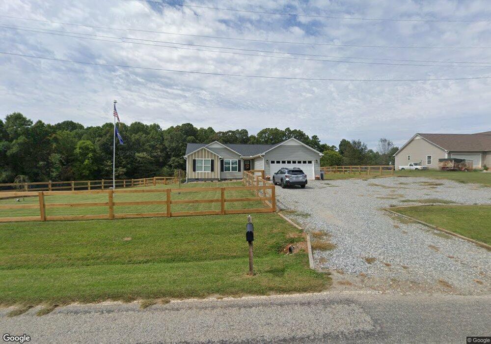
246 Dock Dorsey Rd Cleveland, GA 30528
Estimated Value: $327,785 - $396,000
3
Beds
2
Baths
1,335
Sq Ft
$281/Sq Ft
Est. Value
About This Home
This home is located at 246 Dock Dorsey Rd, Cleveland, GA 30528 and is currently estimated at $374,946, approximately $280 per square foot. 246 Dock Dorsey Rd is a home located in White County with nearby schools including White County 9th Grade Academy, Tesnatee Gap Elementary (Old White County Intermediate), and Jack P. Nix Elementary School.
Ownership History
Date
Name
Owned For
Owner Type
Purchase Details
Closed on
Jul 30, 2021
Sold by
Luna John Carl
Bought by
Peacock Stanley Ray
Current Estimated Value
Home Financials for this Owner
Home Financials are based on the most recent Mortgage that was taken out on this home.
Original Mortgage
$265,000
Outstanding Balance
$240,446
Interest Rate
2.9%
Mortgage Type
VA
Estimated Equity
$134,500
Purchase Details
Closed on
Nov 1, 2017
Sold by
Nelms Robert D
Bought by
Johnson Kelcie Meghan and Luna John Carl
Create a Home Valuation Report for This Property
The Home Valuation Report is an in-depth analysis detailing your home's value as well as a comparison with similar homes in the area
Home Values in the Area
Average Home Value in this Area
Purchase History
| Date | Buyer | Sale Price | Title Company |
|---|---|---|---|
| Peacock Stanley Ray | $265,000 | -- | |
| Johnson Kelcie Meghan | $150,000 | -- |
Source: Public Records
Mortgage History
| Date | Status | Borrower | Loan Amount |
|---|---|---|---|
| Open | Peacock Stanley Ray | $265,000 |
Source: Public Records
Tax History Compared to Growth
Tax History
| Year | Tax Paid | Tax Assessment Tax Assessment Total Assessment is a certain percentage of the fair market value that is determined by local assessors to be the total taxable value of land and additions on the property. | Land | Improvement |
|---|---|---|---|---|
| 2025 | $2,211 | $107,304 | $11,840 | $95,464 |
| 2024 | $2,211 | $106,120 | $10,656 | $95,464 |
| 2023 | $2,092 | $92,244 | $9,472 | $82,772 |
| 2022 | $1,911 | $80,544 | $8,880 | $71,664 |
| 2021 | $1,668 | $62,228 | $6,916 | $55,312 |
| 2020 | $1,590 | $56,504 | $6,424 | $50,080 |
| 2019 | $1,595 | $56,504 | $6,424 | $50,080 |
| 2018 | $1,595 | $56,504 | $6,424 | $50,080 |
Source: Public Records
Map
Nearby Homes
- 22 Laurel Park Dr
- 0 Highway 115 E Unit 10627896
- 0 Highland Forest Rd Unit TRACT "2" 10559371
- 0 Black Rd Unit 7662078
- 0 Black Rd Unit 10620540
- 1021 Black Rd
- 338 Black Rd
- 77 N Shore Dr
- 79 Hampton Hills Ln
- 141 Willows Ct
- 31 Willows Ct
- 37 Stone Hearth Dr
- 164 Leatherford Rd
- 97 E Lake Laceola Rd S
- # 47 Chimney Ln
- LOT 138 Timber Rock Dr
- 148 Chimney Ridge
- 267 Pointe Willow Dr
- 675 Washboard Rd
- 841 Yonah Meadow Dr
- 220 Dock Dorsey Rd
- 158 Dock Dorsey Rd
- 286 Dock Dorsey Rd
- 144 Dock Dorsey Rd
- 25 Guys Dr
- 128 Dock Dorsey Rd
- 102 Dock Dorsey Rd
- 2960 Highway 115 E
- 0 Bennys Dr
- 193 Apple Tree Ln
- 60 Bennys Dr
- 403 Dock Dorsey Rd
- 3038 Highway 115 E Unit B
- 3038 Highway 115 E
- 507 Dock Dorsey Rd
- 3190 Highway 115 E
- 228 Laurel Park Dr
- 3057 Highway 115 E
- 190 Laurel Park Dr
- 551 Dock Dorsey Rd