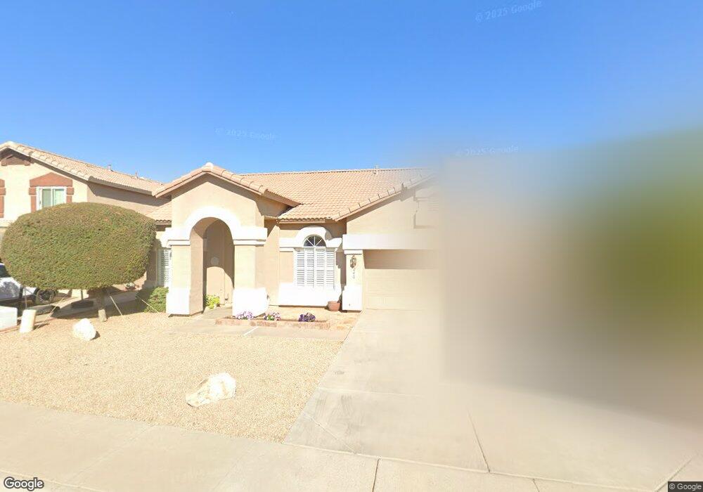
246 E Devon Dr Gilbert, AZ 85296
Heritage District NeighborhoodEstimated Value: $502,000 - $546,000
Studio
3
Baths
1,966
Sq Ft
$270/Sq Ft
Est. Value
About This Home
This home is located at 246 E Devon Dr, Gilbert, AZ 85296 and is currently estimated at $530,936, approximately $270 per square foot. 246 E Devon Dr is a home located in Maricopa County with nearby schools including Settlers Point Elementary School, Mesquite Junior High School, and Mesquite High School.
Ownership History
Date
Name
Owned For
Owner Type
Purchase Details
Closed on
Aug 8, 1996
Sold by
Ditz Crane Builders Llc
Bought by
Thompson Merry Gayle and Thompson Mark
Current Estimated Value
Home Financials for this Owner
Home Financials are based on the most recent Mortgage that was taken out on this home.
Original Mortgage
$118,000
Outstanding Balance
$9,427
Interest Rate
8.33%
Mortgage Type
VA
Estimated Equity
$521,509
Purchase Details
Closed on
Apr 22, 1996
Sold by
Ditz Crane Inc
Bought by
Ditz Crane Builders Llc
Create a Home Valuation Report for This Property
The Home Valuation Report is an in-depth analysis detailing your home's value as well as a comparison with similar homes in the area
Home Values in the Area
Average Home Value in this Area
Purchase History
| Date | Buyer | Sale Price | Title Company |
|---|---|---|---|
| Thompson Merry Gayle | $118,113 | Security Title Agency | |
| Ditz Crane Builders Llc | -- | Security Title |
Source: Public Records
Mortgage History
| Date | Status | Borrower | Loan Amount |
|---|---|---|---|
| Open | Thompson Merry Gayle | $118,000 |
Source: Public Records
Tax History
| Year | Tax Paid | Tax Assessment Tax Assessment Total Assessment is a certain percentage of the fair market value that is determined by local assessors to be the total taxable value of land and additions on the property. | Land | Improvement |
|---|---|---|---|---|
| 2025 | $1,806 | $23,555 | -- | -- |
| 2024 | $1,748 | $22,433 | -- | -- |
| 2023 | $1,748 | $38,110 | $7,620 | $30,490 |
| 2022 | $1,694 | $29,030 | $5,800 | $23,230 |
| 2021 | $1,789 | $27,260 | $5,450 | $21,810 |
| 2020 | $1,760 | $25,300 | $5,060 | $20,240 |
| 2019 | $1,618 | $23,270 | $4,650 | $18,620 |
| 2018 | $1,571 | $21,720 | $4,340 | $17,380 |
| 2017 | $1,517 | $20,420 | $4,080 | $16,340 |
| 2016 | $1,572 | $19,620 | $3,920 | $15,700 |
| 2015 | $1,432 | $18,950 | $3,790 | $15,160 |
Source: Public Records
Map
Nearby Homes
- 313 E Sherri Dr
- 4160 E Brisa Dr
- 4143 E Appaloosa Rd
- 485 E Ranch Rd
- 389 E Arabian Dr
- 558 E Devon Dr
- 434 E Sheffield Ave
- 221 E Appaloosa Ct
- 486 E Windsor Dr
- 549 E Sheffield Ave
- 104 E Palomino Dr
- 670 E Kyle Dr Unit 3
- 669 E Cathy Dr
- 591 E Sheffield Ave
- 681 E Ranch Rd Unit IV
- 741 E Cantebria Dr
- 79 W Gail Dr
- 240 W Brooks St
- 141 W Baylor Ln
- 1051 S Honeysuckle Ln
- 254 E Devon Dr
- 240 E Devon Dr
- 263 E Nunneley Rd
- 257 E Nunneley Rd
- 262 E Devon Dr
- 234 E Devon Dr
- 271 E Nunneley Rd
- 233 E Devon Dr
- 253 E Nunneley Rd
- 228 E Devon Dr
- 1082 S Cottonwood Ct
- 272 E Devon Dr
- 279 E Nunneley Rd
- 227 E Devon Dr
- 222 E Devon Dr
- 1088 S Cottonwood Ct
- 282 E Devon Dr
- 221 E Devon Dr
- 287 E Nunneley Rd
- 262 E Nunneley Rd
Your Personal Tour Guide
Ask me questions while you tour the home.