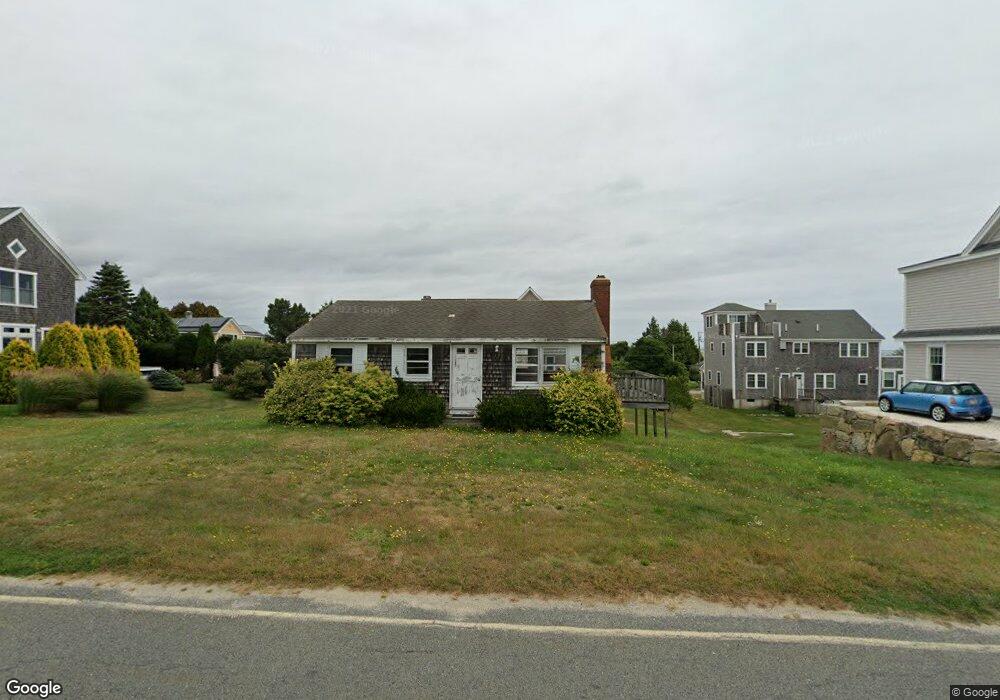
246 Howland Rd Westport, MA 02790
Acoaxet NeighborhoodEstimated Value: $1,614,000 - $1,928,965
2
Beds
1
Bath
768
Sq Ft
$2,374/Sq Ft
Est. Value
About This Home
This home is located at 246 Howland Rd, Westport, MA 02790 and is currently estimated at $1,823,491, approximately $2,374 per square foot. 246 Howland Rd is a home located in Bristol County with nearby schools including Alice A. Macomber Primary School, Westport Elementary School, and Westport Middle-High School.
Ownership History
Date
Name
Owned For
Owner Type
Purchase Details
Closed on
Apr 18, 2019
Sold by
Scott Andrew C and Scott Ian M
Bought by
246 Howland Sp Llc
Current Estimated Value
Home Financials for this Owner
Home Financials are based on the most recent Mortgage that was taken out on this home.
Original Mortgage
$811,250
Outstanding Balance
$711,782
Interest Rate
4.2%
Mortgage Type
Purchase Money Mortgage
Estimated Equity
$1,111,709
Purchase Details
Closed on
Nov 1, 2017
Sold by
Nanni Angela E
Bought by
Scott Andrew C and Scott Ian M
Purchase Details
Closed on
Aug 10, 1982
Bought by
Nanni Angela E
Create a Home Valuation Report for This Property
The Home Valuation Report is an in-depth analysis detailing your home's value as well as a comparison with similar homes in the area
Home Values in the Area
Average Home Value in this Area
Purchase History
| Date | Buyer | Sale Price | Title Company |
|---|---|---|---|
| 246 Howland Sp Llc | $415,000 | -- | |
| Scott Andrew C | $600,000 | -- | |
| Nanni Angela E | $75,000 | -- |
Source: Public Records
Mortgage History
| Date | Status | Borrower | Loan Amount |
|---|---|---|---|
| Open | 246 Howland Sp Llc | $811,250 |
Source: Public Records
Tax History Compared to Growth
Tax History
| Year | Tax Paid | Tax Assessment Tax Assessment Total Assessment is a certain percentage of the fair market value that is determined by local assessors to be the total taxable value of land and additions on the property. | Land | Improvement |
|---|---|---|---|---|
| 2025 | $9,932 | $1,333,100 | $785,300 | $547,800 |
| 2024 | $9,829 | $1,271,500 | $727,600 | $543,900 |
| 2023 | $9,808 | $1,201,900 | $693,000 | $508,900 |
| 2022 | $9,984 | $1,177,300 | $693,000 | $484,300 |
| 2021 | $5,605 | $650,200 | $602,600 | $47,600 |
| 2020 | $5,004 | $593,600 | $578,500 | $15,100 |
| 2019 | $6,422 | $776,500 | $683,600 | $92,900 |
| 2018 | $5,507 | $674,000 | $619,700 | $54,300 |
| 2017 | $5,328 | $668,500 | $615,200 | $53,300 |
| 2016 | $5,274 | $666,800 | $615,200 | $51,600 |
| 2015 | $4,809 | $606,400 | $558,300 | $48,100 |
Source: Public Records
Map
Nearby Homes
- 189 Brayton Point Rd
- 304 Brayton Point Rd
- 19 Seabury Ln
- 255 John Dyer Rd
- 18 Old Barn Rd
- 1881 Main Rd
- 128 Maple Ave
- 0 Reed Rd (Ss)
- 245 John Dyer Rd
- 1580 Main Rd
- 505 Long Hwy
- 141 S Of Commons Rd
- 1702J Drift Rd
- 1702 Drift Rd
- 1346 Main Rd Unit B
- 0 Willow Ave
- 17 Quail Trail
- 116 Amy Hart Path
- 238-242 E Beach Rd
- 536 W Main Rd
- 19A Hillside Rd
- 252 Howland Rd
- 3 Hillside Rd
- 19 Hillside Rd
- 23 Hillside Rd
- 7 Hillside Rd
- 249 Howland Rd
- 243 Howland Rd
- 256 Howland Rd
- 239 Howland Rd
- 255 Howland Rd
- 11 Richmond Pond Ln
- 11 Richmond Pond Dr
- 40 Lakeside Ave
- 26 Hillside Rd
- 262 Howland Rd
- 33 Hillside Rd
- 13 Richmond Pond Ln
- 7 Richmond Pond Ln
- 229 Howland Rd