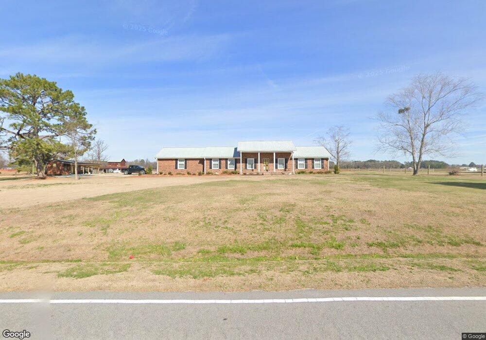
246 Koonce Fork Rd Richlands, NC 28574
Estimated Value: $172,736 - $295,000
3
Beds
2
Baths
2,297
Sq Ft
$102/Sq Ft
Est. Value
About This Home
This home is located at 246 Koonce Fork Rd, Richlands, NC 28574 and is currently estimated at $235,434, approximately $102 per square foot. 246 Koonce Fork Rd is a home located in Onslow County with nearby schools including Richlands Elementary School, Trexler Middle School, and Richlands High School.
Ownership History
Date
Name
Owned For
Owner Type
Purchase Details
Closed on
Dec 2, 2025
Sold by
Wrh Farms Llc
Bought by
Horne Allison Rhea Renee and Horne John Allison
Current Estimated Value
Purchase Details
Closed on
Oct 2, 2021
Sold by
Horne Allison Rhea Renee and Horne John Robert
Bought by
Horne Eddie Ray and Horne Stormy K
Purchase Details
Closed on
Mar 24, 1969
Bought by
Horne Wilbur Ray
Create a Home Valuation Report for This Property
The Home Valuation Report is an in-depth analysis detailing your home's value as well as a comparison with similar homes in the area
Home Values in the Area
Average Home Value in this Area
Purchase History
| Date | Buyer | Sale Price | Title Company |
|---|---|---|---|
| Horne Allison Rhea Renee | -- | None Listed On Document | |
| Horne Eddie Ray | -- | None Listed On Document | |
| Horne Wilbur Ray | -- | -- |
Source: Public Records
Tax History
| Year | Tax Paid | Tax Assessment Tax Assessment Total Assessment is a certain percentage of the fair market value that is determined by local assessors to be the total taxable value of land and additions on the property. | Land | Improvement |
|---|---|---|---|---|
| 2025 | $389 | $59,392 | $49,858 | $9,534 |
| 2024 | $389 | $59,392 | $49,858 | $9,534 |
| 2023 | $389 | $165,924 | $156,390 | $9,534 |
| 2022 | $389 | $165,924 | $156,390 | $9,534 |
| 2021 | $1,432 | $272,220 | $137,140 | $135,080 |
| 2020 | $1,534 | $272,160 | $137,080 | $135,080 |
| 2019 | $1,534 | $272,160 | $137,080 | $135,080 |
| 2018 | $1,534 | $272,160 | $137,080 | $135,080 |
| 2017 | $1,462 | $271,190 | $137,080 | $134,110 |
| 2016 | $1,462 | $216,530 | $0 | $0 |
| 2015 | $1,462 | $216,530 | $0 | $0 |
| 2014 | $1,462 | $216,530 | $0 | $0 |
Source: Public Records
Map
Nearby Homes
- 135 Koonce Fork Rd
- 302 Pete Jones Dr
- 978 Kinston Hwy
- 00 Kinston Hwy
- 203 W Foy St
- 112 W Foy St
- 149 Huffmantown Rd
- 672 E Hargett St
- 190 Huffmantown Rd
- 241 Winstead Loop Rd
- 252 Winstead Loop
- 254 Winstead Loop
- 308 Winstead Loop Rd
- 745 Greenwich Place
- 600 Central Park Way
- 104 Eva Koonce Ln
- 106 Dukes Lake Cir
- 107 Woods Run Cir
- 108 Woods Run Cir
- 303 Maidstone Dr
- 234 Koonce Fork Rd
- 247 Koonce Fork Rd
- 243 Koonce Fork Rd
- 251 Koonce Fork Rd
- 239 Koonce Fork Rd
- 257 Koonce Fork Rd
- 101 S Poplar Dr
- 0 Koonce Fork Rd Unit 100115706
- 000 Koonce Fork Rd
- 0 Koonce Fork Rd
- 110 Turtle Shell Rd
- 263 Koonce Fork Rd
- 100 S Poplar Dr
- 103 S Poplar Dr
- 114 Turtle Shell Rd
- 269 Koonce Fork Rd
- 105 S Poplar Dr
- 102 S Poplar Dr
- 106 River Dr
- 107 S Poplar Dr
Your Personal Tour Guide
Ask me questions while you tour the home.