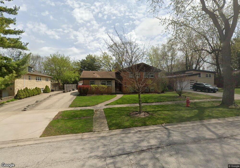
246 Locust Rd Wilmette, IL 60091
Estimated Value: $615,000 - $860,000
4
Beds
2
Baths
1,503
Sq Ft
$485/Sq Ft
Est. Value
About This Home
This home is located at 246 Locust Rd, Wilmette, IL 60091 and is currently estimated at $729,369, approximately $485 per square foot. 246 Locust Rd is a home located in Cook County with nearby schools including Romona Elementary School, Highcrest Middle School, and Wilmette Junior High School.
Ownership History
Date
Name
Owned For
Owner Type
Purchase Details
Closed on
Feb 19, 2025
Sold by
Bennewitz Kirk T and Novy-Bennewitz Cara
Bought by
Kirk Bennewitz And Cara Novy Bennewitz Trust and Bennewitz
Current Estimated Value
Purchase Details
Closed on
Jun 17, 1999
Sold by
Smith Gerald A and Smith Stephanie B
Bought by
Novy Bennewitz Kirk T and Novy Bennewitz Cara
Home Financials for this Owner
Home Financials are based on the most recent Mortgage that was taken out on this home.
Original Mortgage
$238,000
Interest Rate
7.06%
Create a Home Valuation Report for This Property
The Home Valuation Report is an in-depth analysis detailing your home's value as well as a comparison with similar homes in the area
Home Values in the Area
Average Home Value in this Area
Purchase History
| Date | Buyer | Sale Price | Title Company |
|---|---|---|---|
| Kirk Bennewitz And Cara Novy Bennewitz Trust | -- | None Listed On Document | |
| Novy Bennewitz Kirk T | $297,500 | Ticor Title |
Source: Public Records
Mortgage History
| Date | Status | Borrower | Loan Amount |
|---|---|---|---|
| Previous Owner | Novy Bennewitz Kirk T | $238,000 |
Source: Public Records
Tax History
| Year | Tax Paid | Tax Assessment Tax Assessment Total Assessment is a certain percentage of the fair market value that is determined by local assessors to be the total taxable value of land and additions on the property. | Land | Improvement |
|---|---|---|---|---|
| 2025 | $9,996 | $60,000 | $17,638 | $42,362 |
| 2024 | $9,996 | $47,163 | $14,698 | $32,465 |
| 2023 | $9,421 | $50,020 | $14,698 | $35,322 |
| 2022 | $9,421 | $50,020 | $14,698 | $35,322 |
| 2021 | $8,372 | $38,220 | $10,498 | $27,722 |
| 2020 | $8,340 | $38,220 | $10,498 | $27,722 |
| 2019 | $8,173 | $42,001 | $10,498 | $31,503 |
| 2018 | $7,610 | $35,421 | $8,818 | $26,603 |
| 2017 | $8,074 | $38,277 | $8,818 | $29,459 |
| 2016 | $8,375 | $41,027 | $8,818 | $32,209 |
| 2015 | $7,207 | $31,653 | $7,349 | $24,304 |
| 2014 | $7,105 | $31,653 | $7,349 | $24,304 |
| 2013 | $7,566 | $35,057 | $7,349 | $27,708 |
Source: Public Records
Map
Nearby Homes
- 408 Beverly Dr
- 428 Beverly Dr
- 321 Vine St
- 4710 Russett Ln Unit R1
- 2611 Laurel Ln
- 139 Thelin Ct
- 10116 Peach Pkwy Unit N110
- 10015 Beverly Dr Unit 404
- 201 Valley View Dr
- 2931 Greenleaf Ave
- 2239 Washington Ave
- 10059 Frontage Rd Unit F
- 2611 Lake Ave
- 2047 Wilmette Ave
- 408 Lavergne Ave
- 700 Lamon Ave
- 3314 Central St Unit A
- 2501 Crawford Ave
- 2938 Indianwood Rd
- 1011 Mohawk Rd
- 240 Locust Rd
- 250 Locust Rd
- 335 Brookside Dr
- 236 Locust Rd
- 339 Brookside Dr
- 331 Brookside Dr
- 343 Brookside Dr
- 247 Locust Rd
- 230 Locust Rd
- 241 Locust Rd
- 251 Locust Rd
- 347 Brookside Dr
- 237 Locust Rd
- 323 Brookside Dr
- 224 Locust Rd
- 231 Locust Rd
- 246 Westmoreland Dr
- 312 Locust Rd
- 225 Locust Rd
- 330 Brookside Dr