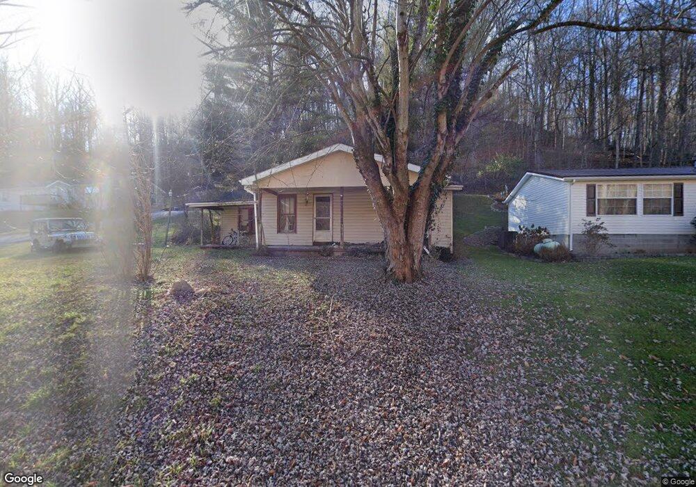
2465 County Road 181 Ironton, OH 45638
Estimated Value: $75,276 - $89,000
2
Beds
1
Bath
1,034
Sq Ft
$77/Sq Ft
Est. Value
About This Home
This home is located at 2465 County Road 181, Ironton, OH 45638 and is currently estimated at $80,092, approximately $77 per square foot. 2465 County Road 181 is a home located in Lawrence County with nearby schools including Rock Hill Elementary School, Rock Hill Middle School, and Rock Hill Senior High School.
Ownership History
Date
Name
Owned For
Owner Type
Purchase Details
Closed on
Dec 14, 2023
Sold by
Lawrence County
Bought by
Hill Theresa and Miller Jennifer Julie
Current Estimated Value
Purchase Details
Closed on
Dec 22, 2011
Sold by
Deutsche Bank National Trust Company
Bought by
Hill Theresa
Purchase Details
Closed on
Sep 28, 2011
Sold by
Miller Kenneth and Miller Joann
Bought by
Deutsche Bank National Trust Company
Purchase Details
Closed on
Jul 3, 2000
Sold by
Maddy Dale Edward
Bought by
Miller Kenneth and Miller Joann
Create a Home Valuation Report for This Property
The Home Valuation Report is an in-depth analysis detailing your home's value as well as a comparison with similar homes in the area
Home Values in the Area
Average Home Value in this Area
Purchase History
| Date | Buyer | Sale Price | Title Company |
|---|---|---|---|
| Hill Theresa | $4,074 | None Listed On Document | |
| Hill Theresa | $4,074 | None Listed On Document | |
| Hill Theresa | $11,000 | Attorney | |
| Deutsche Bank National Trust Company | $26,334 | Attorney | |
| Miller Kenneth | $19,000 | -- |
Source: Public Records
Tax History Compared to Growth
Tax History
| Year | Tax Paid | Tax Assessment Tax Assessment Total Assessment is a certain percentage of the fair market value that is determined by local assessors to be the total taxable value of land and additions on the property. | Land | Improvement |
|---|---|---|---|---|
| 2024 | -- | $3,750 | $3,750 | -- |
| 2023 | $156 | $4,890 | $3,750 | $1,140 |
| 2022 | $166 | $5,270 | $3,750 | $1,520 |
| 2021 | $163 | $5,610 | $3,540 | $2,070 |
| 2020 | $477 | $15,750 | $3,540 | $12,210 |
| 2019 | $475 | $15,750 | $3,540 | $12,210 |
| 2018 | $542 | $17,860 | $3,540 | $14,320 |
| 2017 | $542 | $17,860 | $3,540 | $14,320 |
| 2016 | $500 | $17,860 | $3,540 | $14,320 |
| 2015 | $486 | $17,060 | $3,530 | $13,530 |
| 2014 | $485 | $17,060 | $3,530 | $13,530 |
| 2013 | $484 | $17,060 | $3,530 | $13,530 |
Source: Public Records
Map
Nearby Homes
- 2480 County Road 181
- 0 County Road 181 Unit 24215136
- 0 County Road 181 Unit 11540303
- 3894 State Route 141
- 1917 Woodland Dr
- 2616 S 13th St
- 2620 S 13th St
- 2418 S 12th St
- 2001 Liberty Ave
- 2626 S 11th St
- 1222 Osage Ct
- 1219 Penobscot Trail
- 0 S 10th St
- 2503 S 9th St
- 309 High St
- 309 High St Unit LAO-5
- 2726 S 9th St
- 2008 S 9th St
- 2008 S 9th St Unit KO-2
- 2721 S 8th St
- 2437 County Road 181
- 2501 County Road 181
- 2525 County Road 181
- 2407 County Road 181
- 2508 County Road 181
- 2548 County Road 181
- 2467 County Road 181
- 2398 County Road 181
- 2367 County Road 181
- 0 County Road 181 Unit 161639
- 0 County Road 181 Unit 180542
- 0 County Road 181 Unit 11274841
- 0 County Road 181 Unit 223039239
- 0 County Road 181 Unit 176385
- 0 County Road 181 Unit 174357
- 0 County Road 181 Unit 173244
- 2617 County Road 181
- 2358 County Road 181
- 2339 County Road 181
- 2340 County Road 181