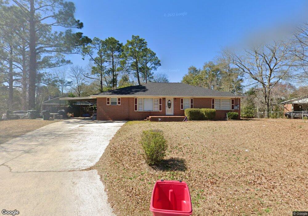
2466 Bristol Dr Macon, GA 31217
Estimated Value: $100,000 - $128,000
3
Beds
2
Baths
2,030
Sq Ft
$56/Sq Ft
Est. Value
About This Home
This home is located at 2466 Bristol Dr, Macon, GA 31217 and is currently estimated at $113,069, approximately $55 per square foot. 2466 Bristol Dr is a home located in Bibb County with nearby schools including Martin Luther King Jr. Elementary School, Appling Middle School, and Northeast High School.
Ownership History
Date
Name
Owned For
Owner Type
Purchase Details
Closed on
Jan 4, 2007
Sold by
Glover Katherine Bonita
Bought by
Farris Katherine B
Current Estimated Value
Home Financials for this Owner
Home Financials are based on the most recent Mortgage that was taken out on this home.
Original Mortgage
$88,000
Outstanding Balance
$60,102
Interest Rate
9.15%
Mortgage Type
Stand Alone First
Estimated Equity
$52,967
Purchase Details
Closed on
Jan 31, 2002
Create a Home Valuation Report for This Property
The Home Valuation Report is an in-depth analysis detailing your home's value as well as a comparison with similar homes in the area
Home Values in the Area
Average Home Value in this Area
Purchase History
| Date | Buyer | Sale Price | Title Company |
|---|---|---|---|
| Farris Katherine B | -- | None Available | |
| -- | -- | -- |
Source: Public Records
Mortgage History
| Date | Status | Borrower | Loan Amount |
|---|---|---|---|
| Open | Farris Katherine B | $88,000 |
Source: Public Records
Tax History Compared to Growth
Tax History
| Year | Tax Paid | Tax Assessment Tax Assessment Total Assessment is a certain percentage of the fair market value that is determined by local assessors to be the total taxable value of land and additions on the property. | Land | Improvement |
|---|---|---|---|---|
| 2025 | $890 | $43,206 | $3,630 | $39,576 |
| 2024 | $920 | $43,206 | $3,630 | $39,576 |
| 2023 | $462 | $43,206 | $3,630 | $39,576 |
| 2022 | $752 | $28,735 | $2,464 | $26,271 |
| 2021 | $540 | $21,207 | $1,643 | $19,564 |
| 2020 | $432 | $18,138 | $1,369 | $16,769 |
| 2019 | $436 | $18,138 | $1,369 | $16,769 |
| 2018 | $848 | $18,138 | $1,369 | $16,769 |
| 2017 | $417 | $18,138 | $1,369 | $16,769 |
| 2016 | $385 | $18,138 | $1,369 | $16,769 |
| 2015 | $568 | $18,594 | $1,825 | $16,769 |
| 2014 | $756 | $19,507 | $2,738 | $16,769 |
Source: Public Records
Map
Nearby Homes
- 2229 New Clinton Rd
- 2675 Andy Dr
- 2370 Recreation Rd
- 2720 Jordan Ave
- 2130 New Clinton Rd
- 2954 Tyler Place
- 2146 Melton Ave
- 2066 Melton Ave
- 3048 Bethune Ave
- 2940 Shurling Dr
- 2792 Skyline Dr
- 860 Morningside Dr
- 1840 Kinder Kare Dr
- 1818 Kinder Kare Dr
- 875 Artic Cir
- 3128 Commodore Dr
- 837 Artic Cir
- 3145 Pasadena Dr
- 875 Artic Place
- 2396 Danbury Dr
- 2478 Bristol Dr
- 2388 Danbury Dr
- 2431 Millerfield Rd
- 2467 Bristol Dr
- 2473 Bristol Dr
- 2461 Bristol Dr
- 2382 Danbury Dr
- 2419 Millerfield Rd
- 2446 Bristol Dr
- 2479 Bristol Dr
- 2455 Bristol Dr
- 2409 Millerfield Rd
- 2374 Danbury Dr
- 2449 Bristol Dr
- 2381 Danbury Dr
- 2399 Millerfield Rd
- 2438 Bristol Dr
- 2443 Bristol Dr
- 2512 Millerfield Rd