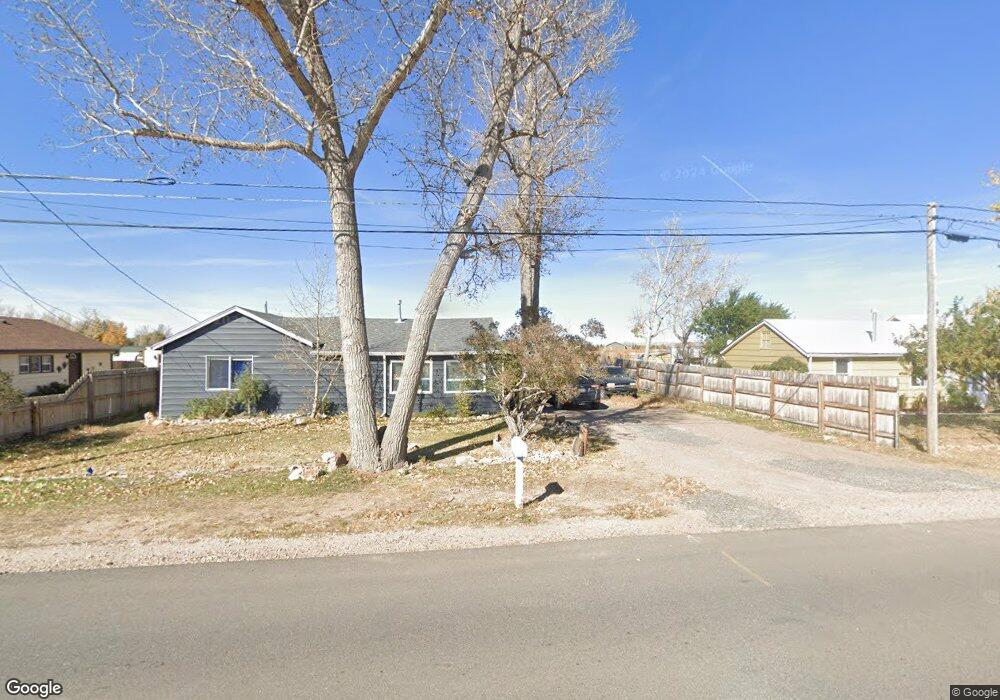
2467 Riverside Dr Laramie, WY 82070
Estimated Value: $249,000 - $364,000
2
Beds
1
Bath
1,140
Sq Ft
$268/Sq Ft
Est. Value
About This Home
This home is located at 2467 Riverside Dr, Laramie, WY 82070 and is currently estimated at $305,143, approximately $267 per square foot. 2467 Riverside Dr is a home located in Albany County with nearby schools including Velma Linford Elementary School, Laramie Middle School, and Laramie High School.
Ownership History
Date
Name
Owned For
Owner Type
Purchase Details
Closed on
Nov 29, 2020
Sold by
Gbp Partnership
Bought by
Arledge Kenneth Martin
Current Estimated Value
Purchase Details
Closed on
Apr 3, 2006
Sold by
Pier Robert Wayne and Pier Barbara K
Bought by
Gbp Partnership and Gallegos Arthur J
Home Financials for this Owner
Home Financials are based on the most recent Mortgage that was taken out on this home.
Original Mortgage
$110,000
Interest Rate
6.24%
Mortgage Type
Seller Take Back
Create a Home Valuation Report for This Property
The Home Valuation Report is an in-depth analysis detailing your home's value as well as a comparison with similar homes in the area
Home Values in the Area
Average Home Value in this Area
Purchase History
| Date | Buyer | Sale Price | Title Company |
|---|---|---|---|
| Arledge Kenneth Martin | -- | None Available | |
| Gbp Partnership | -- | -- |
Source: Public Records
Mortgage History
| Date | Status | Borrower | Loan Amount |
|---|---|---|---|
| Previous Owner | Gbp Partnership | $110,000 |
Source: Public Records
Tax History Compared to Growth
Tax History
| Year | Tax Paid | Tax Assessment Tax Assessment Total Assessment is a certain percentage of the fair market value that is determined by local assessors to be the total taxable value of land and additions on the property. | Land | Improvement |
|---|---|---|---|---|
| 2025 | $1,518 | $19,436 | $5,093 | $14,343 |
| 2024 | $1,518 | $20,796 | $3,354 | $17,442 |
| 2023 | $1,535 | $21,022 | $3,042 | $17,980 |
| 2022 | $495 | $6,786 | $2,857 | $3,929 |
| 2021 | $485 | $6,638 | $2,857 | $3,781 |
| 2020 | $920 | $12,596 | $2,857 | $9,739 |
| 2019 | $877 | $12,008 | $2,857 | $9,151 |
| 2018 | $943 | $12,924 | $2,857 | $10,067 |
| 2017 | $914 | $12,519 | $2,857 | $9,662 |
| 2016 | $942 | $12,901 | $2,857 | $10,044 |
| 2015 | $975 | $13,354 | $2,484 | $10,870 |
| 2014 | $971 | $13,301 | $0 | $0 |
Source: Public Records
Map
Nearby Homes
- 1416 S Colorado Ave
- 1414 S Colorado Ave
- 1412 S Colorado Ave
- 1410 S Colorado Ave
- 1886 Riverside Dr
- 2260 Franklin St Unit 27
- 2260 Franklin St Unit 38
- 8 Star Struck Ln
- 627 S Colorado Ave
- 1012 A-B S Colorado Ave
- 1990 Truman St
- 541 S Johnson St
- TBD Wyoming 230
- 509 S Hayes St
- 1866 Truman St
- 529 S Pierce St
- 370 S Buchanan St
- 427 S Pierce St
- 2073 Monroe St
- 2075 Jefferson St
- 2475 Riverside Dr
- 2457 Riverside Dr
- 2485 Riverside Dr
- 2460 Riverside Dr
- 2389 Riverside Dr
- 2484 Riverside Dr
- 2553 Riverside Dr
- 2561 Riverside Dr
- 2382 Riverside Dr
- 1737 Connors Ave
- 1811 Connors Ave
- 2560 Riverside Dr
- 1635 Connors Ave
- 2570 Riverside Dr
- 2355 Riverside Dr
- 1812 Connors Ave
- 2579 Riverside Dr
- 2370 Riverside Dr
- 2354 Riverside Dr
- 2578 Riverside Dr