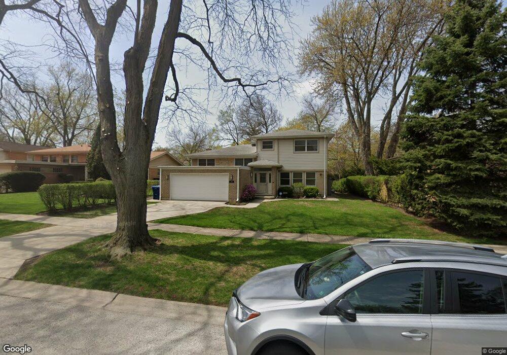
247 Locust Rd Wilmette, IL 60091
Estimated Value: $721,871 - $865,000
4
Beds
4
Baths
1,901
Sq Ft
$412/Sq Ft
Est. Value
About This Home
This home is located at 247 Locust Rd, Wilmette, IL 60091 and is currently estimated at $782,968, approximately $411 per square foot. 247 Locust Rd is a home located in Cook County with nearby schools including Romona Elementary School, Highcrest Middle School, and Wilmette Junior High School.
Ownership History
Date
Name
Owned For
Owner Type
Purchase Details
Closed on
May 27, 2008
Sold by
Samotny Arnold B and Samotny Paloma
Bought by
Samotny Arnold and Arnold Samotny Trust
Current Estimated Value
Purchase Details
Closed on
Oct 8, 2001
Sold by
Price Dorothy
Bought by
Samotny Arnold B
Home Financials for this Owner
Home Financials are based on the most recent Mortgage that was taken out on this home.
Original Mortgage
$100,000
Outstanding Balance
$37,275
Interest Rate
6.69%
Estimated Equity
$745,693
Create a Home Valuation Report for This Property
The Home Valuation Report is an in-depth analysis detailing your home's value as well as a comparison with similar homes in the area
Home Values in the Area
Average Home Value in this Area
Purchase History
| Date | Buyer | Sale Price | Title Company |
|---|---|---|---|
| Samotny Arnold | -- | None Available | |
| Samotny Arnold B | $265,000 | Professional National Title |
Source: Public Records
Mortgage History
| Date | Status | Borrower | Loan Amount |
|---|---|---|---|
| Open | Samotny Arnold B | $100,000 |
Source: Public Records
Tax History
| Year | Tax Paid | Tax Assessment Tax Assessment Total Assessment is a certain percentage of the fair market value that is determined by local assessors to be the total taxable value of land and additions on the property. | Land | Improvement |
|---|---|---|---|---|
| 2025 | $11,322 | $72,000 | $17,499 | $54,501 |
| 2024 | $11,322 | $51,178 | $14,583 | $36,595 |
| 2023 | $11,507 | $53,211 | $14,583 | $38,628 |
| 2022 | $11,507 | $57,000 | $14,583 | $42,417 |
| 2021 | $7,350 | $31,622 | $10,416 | $21,206 |
| 2020 | $7,288 | $31,622 | $10,416 | $21,206 |
| 2019 | $7,145 | $34,750 | $10,416 | $24,334 |
| 2018 | $11,262 | $50,774 | $8,749 | $42,025 |
| 2017 | $12,002 | $55,260 | $8,749 | $46,511 |
| 2016 | $11,953 | $57,488 | $8,749 | $48,739 |
| 2015 | $6,535 | $28,949 | $7,291 | $21,658 |
| 2014 | $6,445 | $28,949 | $7,291 | $21,658 |
| 2013 | $6,141 | $28,949 | $7,291 | $21,658 |
Source: Public Records
Map
Nearby Homes
- 408 Beverly Dr
- 428 Beverly Dr
- 4710 Russett Ln Unit R1
- 321 Vine St
- 2611 Laurel Ln
- 10116 Peach Pkwy Unit N110
- 201 Valley View Dr
- 10015 Beverly Dr Unit 404
- 2931 Greenleaf Ave
- 10059 Frontage Rd Unit F
- 2645 Lake Ave
- 2239 Washington Ave
- 2611 Lake Ave
- 408 Lavergne Ave
- 909 Locust Rd
- 700 Lamon Ave
- 2047 Wilmette Ave
- 3314 Central St Unit A
- 2938 Indianwood Rd
- 3031 Indianwood Rd
- 241 Locust Rd
- 251 Locust Rd
- 246 Westmoreland Dr
- 237 Locust Rd
- 244 Westmoreland Dr
- 246 Locust Rd
- 231 Locust Rd
- 240 Locust Rd
- 250 Locust Rd
- 242 Westmoreland Dr
- 236 Locust Rd
- 311 Locust Rd
- 225 Locust Rd
- 326 Beverly Dr
- 230 Locust Rd
- 324 Beverly Dr
- 335 Brookside Dr
- 240 Westmoreland Dr
- 250 Westmoreland Dr
- 325 Locust Rd
Your Personal Tour Guide
Ask me questions while you tour the home.