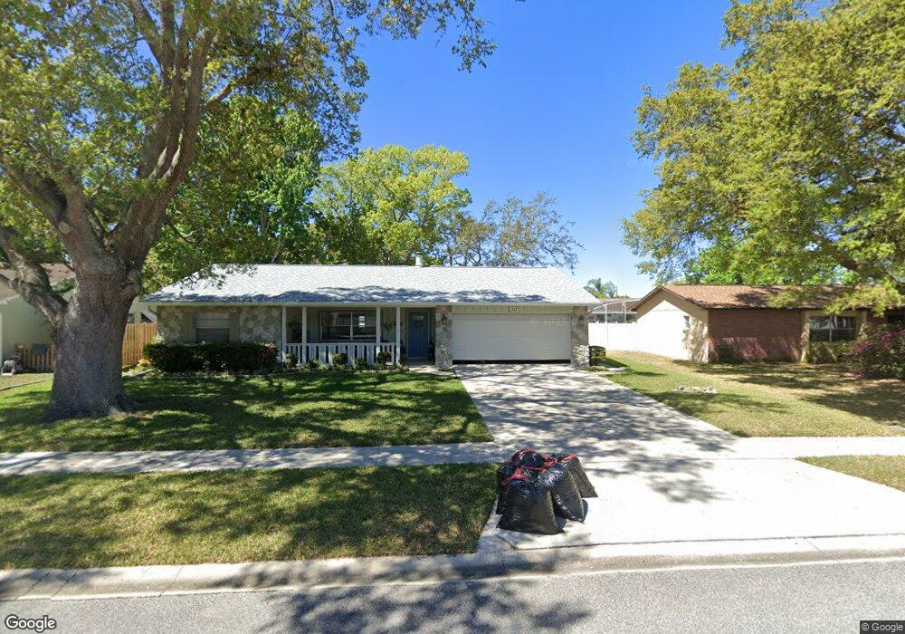
247 Manhattan Way Port Orange, FL 32129
North Port Orange NeighborhoodEstimated Value: $263,673 - $295,000
3
Beds
2
Baths
1,304
Sq Ft
$214/Sq Ft
Est. Value
About This Home
This home is located at 247 Manhattan Way, Port Orange, FL 32129 and is currently estimated at $279,668, approximately $214 per square foot. 247 Manhattan Way is a home located in Volusia County with nearby schools including Sheridan Green Elementary School, Sugar Mill Elementary School, and Atlantic High School.
Ownership History
Date
Name
Owned For
Owner Type
Purchase Details
Closed on
Oct 15, 1987
Bought by
Sheehan Timothy F and Sheehan Diane C
Current Estimated Value
Purchase Details
Closed on
Sep 15, 1987
Bought by
Sheehan Timothy F and Sheehan Diane C
Purchase Details
Closed on
Jul 15, 1987
Bought by
Sheehan Timothy F and Sheehan Diane C
Purchase Details
Closed on
Nov 15, 1978
Bought by
Sheehan Timothy F and Sheehan Diane C
Purchase Details
Closed on
Dec 15, 1977
Bought by
Sheehan Timothy F and Sheehan Diane C
Create a Home Valuation Report for This Property
The Home Valuation Report is an in-depth analysis detailing your home's value as well as a comparison with similar homes in the area
Home Values in the Area
Average Home Value in this Area
Purchase History
| Date | Buyer | Sale Price | Title Company |
|---|---|---|---|
| Sheehan Timothy F | $58,000 | -- | |
| Sheehan Timothy F | $100 | -- | |
| Sheehan Timothy F | $16,000 | -- | |
| Sheehan Timothy F | $38,500 | -- | |
| Sheehan Timothy F | $902,400 | -- |
Source: Public Records
Tax History Compared to Growth
Tax History
| Year | Tax Paid | Tax Assessment Tax Assessment Total Assessment is a certain percentage of the fair market value that is determined by local assessors to be the total taxable value of land and additions on the property. | Land | Improvement |
|---|---|---|---|---|
| 2025 | $1,025 | $98,963 | -- | -- |
| 2024 | $1,025 | $96,174 | -- | -- |
| 2023 | $1,025 | $93,373 | $0 | $0 |
| 2022 | $968 | $90,653 | $0 | $0 |
| 2021 | $971 | $88,013 | $0 | $0 |
| 2020 | $943 | $86,798 | $0 | $0 |
| 2019 | $906 | $84,847 | $0 | $0 |
| 2018 | $896 | $83,265 | $0 | $0 |
| 2017 | $888 | $81,552 | $0 | $0 |
| 2016 | $870 | $79,875 | $0 | $0 |
| 2015 | $891 | $79,320 | $0 | $0 |
| 2014 | $889 | $78,690 | $0 | $0 |
Source: Public Records
Map
Nearby Homes
- 766 Greenfield Dr
- 151 Brandy Hills Dr
- 762 Greenfield Dr
- 67 Golden Gate Cir
- 121 Aloha Terrace
- 132 Stone Gate Ln
- 1118 Meditation Loop
- 711 Gilpin Way
- 109 Stone Gate Ln
- 715 Larado Dr
- 106 Aloha Terrace
- 93 Glass Ct
- 709 Fieldstone Ave
- 103 Aloha Terrace
- 3531 Red Pontiac Dr
- 760 Rolling Hills Dr
- 54 Fall Dr
- 803 Deer Springs Rd
- 1502 Deer Springs Rd
- 115 Fall Dr
- 33 E Bella Lago Cir E
- 246 Manhattan Way
- 248 Manhattan Way
- 238 Peppermint Way
- 0000 Confidential Unit 101
- 239 Peppermint Way
- 237 Peppermint Way
- 245 Manhattan Way
- 249 Manhattan Way
- 268 Manhattan Way Unit 2
- 269 Manhattan Way
- 267 Manhattan Way
- 240 Peppermint Way
- 236 Peppermint Way
- 270 Manhattan Way
- 266 Manhattan Way
- 244 Manhattan Way
- 250 Manhattan Way
- 241 Peppermint Way
- 235 Peppermint Way