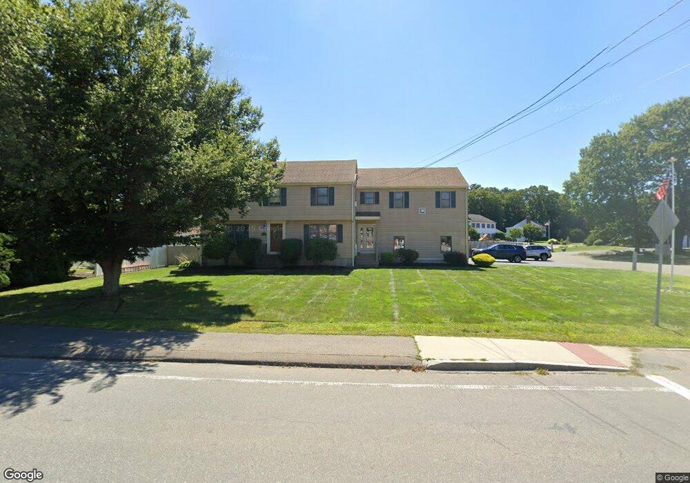
247 Park Ave South Weymouth, MA 02190
South Weymouth NeighborhoodEstimated Value: $903,000 - $1,115,000
5
Beds
5
Baths
3,180
Sq Ft
$323/Sq Ft
Est. Value
About This Home
This home is located at 247 Park Ave, South Weymouth, MA 02190 and is currently estimated at $1,026,819, approximately $322 per square foot. 247 Park Ave is a home located in Norfolk County with nearby schools including Ralph Talbot Primary School, Abigail Adams Middle School, and Weymouth Middle School Chapman.
Ownership History
Date
Name
Owned For
Owner Type
Purchase Details
Closed on
Jan 9, 2018
Sold by
Conners Michael C and Conners Kathleen F
Bought by
Mccue Kevin J and Mccue Megan
Current Estimated Value
Purchase Details
Closed on
Nov 3, 1988
Sold by
Pompeo Rudy V
Bought by
Connors Michael C
Home Financials for this Owner
Home Financials are based on the most recent Mortgage that was taken out on this home.
Original Mortgage
$40,000
Interest Rate
10.33%
Mortgage Type
Purchase Money Mortgage
Create a Home Valuation Report for This Property
The Home Valuation Report is an in-depth analysis detailing your home's value as well as a comparison with similar homes in the area
Home Values in the Area
Average Home Value in this Area
Purchase History
| Date | Buyer | Sale Price | Title Company |
|---|---|---|---|
| Mccue Kevin J | -- | -- | |
| Connors Michael C | $228,000 | -- |
Source: Public Records
Mortgage History
| Date | Status | Borrower | Loan Amount |
|---|---|---|---|
| Previous Owner | Connors Michael C | $60,000 | |
| Previous Owner | Connors Michael C | $50,000 | |
| Previous Owner | Connors Michael C | $55,000 | |
| Previous Owner | Connors Michael C | $40,000 |
Source: Public Records
Tax History Compared to Growth
Tax History
| Year | Tax Paid | Tax Assessment Tax Assessment Total Assessment is a certain percentage of the fair market value that is determined by local assessors to be the total taxable value of land and additions on the property. | Land | Improvement |
|---|---|---|---|---|
| 2025 | $10,517 | $1,041,300 | $215,600 | $825,700 |
| 2024 | $10,269 | $999,900 | $205,300 | $794,600 |
| 2023 | $9,430 | $902,400 | $190,100 | $712,300 |
| 2022 | $9,069 | $791,400 | $176,100 | $615,300 |
| 2021 | $8,632 | $735,300 | $176,100 | $559,200 |
| 2020 | $8,358 | $701,200 | $176,100 | $525,100 |
| 2019 | $8,147 | $672,200 | $169,300 | $502,900 |
| 2018 | $5,494 | $439,500 | $161,200 | $278,300 |
| 2017 | $5,367 | $419,000 | $153,600 | $265,400 |
| 2016 | $5,160 | $403,100 | $147,700 | $255,400 |
| 2015 | $4,758 | $368,800 | $132,900 | $235,900 |
| 2014 | $4,741 | $356,500 | $137,400 | $219,100 |
Source: Public Records
Map
Nearby Homes
- 261 Pleasant St Unit 5
- 45 Union St
- 120 Burkhall St Unit K
- 5 Oak St
- 206 Pine St
- 27 Park Ave
- 41 Oak St
- 200 Burkhall St Unit 803
- 159 Tall Oaks Dr Unit D
- 121 Tall Oaks Dr Unit Q
- 17 Sears Rd
- 446 Ralph Talbot St
- 299 Union St
- 685 Main St Unit 3
- 30 Alroy Rd
- 54 Old Quarry Dr
- 2 Mitchell Ln Unit B
- 54 Fountain Ln Unit 9
- 197 White St
- 1050 Main St Unit 1
- 255 Park Ave
- 16 Stephen Rennie Dr
- 7 Stephen Rennie Dr
- 17 Stephen Rennie Dr
- 138 Ralph Talbot St
- 269 Park Ave
- 24 Stephen Rennie Dr
- 126 Ralph Talbot St
- 260 Park Ave
- 232 Park Ave
- 225 Park Ave
- 225 Park Ave Unit 1
- 29 Stephen Rennie Dr
- 118 Ralph Talbot St
- 168 Ralph Talbot St
- 228 Park Ave
- 270 Park Ave
- 36 Stephen Rennie Dr
- 224 Park Ave
- 90 Ralston Rd