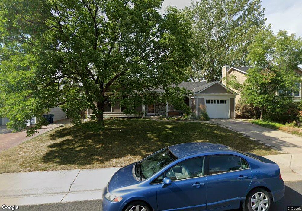
247 S Madison Ave Louisville, CO 80027
Estimated Value: $702,000 - $791,000
3
Beds
2
Baths
1,324
Sq Ft
$554/Sq Ft
Est. Value
About This Home
This home is located at 247 S Madison Ave, Louisville, CO 80027 and is currently estimated at $733,531, approximately $554 per square foot. 247 S Madison Ave is a home located in Boulder County with nearby schools including Fireside Elementary School, Monarch K-8 School, and Monarch High School.
Ownership History
Date
Name
Owned For
Owner Type
Purchase Details
Closed on
Jul 14, 2003
Sold by
Mays Virginia K
Bought by
Dagiau Tony
Current Estimated Value
Home Financials for this Owner
Home Financials are based on the most recent Mortgage that was taken out on this home.
Original Mortgage
$202,500
Outstanding Balance
$77,906
Interest Rate
4%
Mortgage Type
Purchase Money Mortgage
Estimated Equity
$655,625
Purchase Details
Closed on
Aug 30, 2002
Sold by
Loomis Curt J and Loomis Anette Rae
Bought by
Mays Virginia K
Home Financials for this Owner
Home Financials are based on the most recent Mortgage that was taken out on this home.
Original Mortgage
$175,200
Interest Rate
6.33%
Purchase Details
Closed on
May 20, 1983
Bought by
Dagiau Tony & Julie Living Trust
Purchase Details
Closed on
Mar 26, 1982
Bought by
Dagiau Tony & Julie Living Trust
Create a Home Valuation Report for This Property
The Home Valuation Report is an in-depth analysis detailing your home's value as well as a comparison with similar homes in the area
Home Values in the Area
Average Home Value in this Area
Purchase History
| Date | Buyer | Sale Price | Title Company |
|---|---|---|---|
| Dagiau Tony | $232,700 | Commonwealth Title | |
| Mays Virginia K | $219,000 | Land Title | |
| Dagiau Tony & Julie Living Trust | $76,700 | -- | |
| Dagiau Tony & Julie Living Trust | -- | -- |
Source: Public Records
Mortgage History
| Date | Status | Borrower | Loan Amount |
|---|---|---|---|
| Open | Dagiau Tony | $202,500 | |
| Previous Owner | Mays Virginia K | $175,200 |
Source: Public Records
Tax History Compared to Growth
Tax History
| Year | Tax Paid | Tax Assessment Tax Assessment Total Assessment is a certain percentage of the fair market value that is determined by local assessors to be the total taxable value of land and additions on the property. | Land | Improvement |
|---|---|---|---|---|
| 2025 | $3,614 | $41,144 | $18,925 | $22,219 |
| 2024 | $3,614 | $41,144 | $18,925 | $22,219 |
| 2023 | $3,553 | $40,213 | $20,040 | $23,859 |
| 2022 | $2,974 | $30,907 | $14,248 | $16,659 |
| 2021 | $3,272 | $35,328 | $16,288 | $19,040 |
| 2020 | $3,004 | $32,104 | $13,156 | $18,948 |
| 2019 | $2,962 | $32,104 | $13,156 | $18,948 |
| 2018 | $2,325 | $26,021 | $8,856 | $17,165 |
| 2017 | $2,278 | $28,768 | $9,791 | $18,977 |
| 2016 | $2,298 | $26,117 | $10,587 | $15,530 |
| 2015 | $2,178 | $22,017 | $12,099 | $9,918 |
| 2014 | $1,882 | $22,017 | $12,099 | $9,918 |
Source: Public Records
Map
Nearby Homes
- 641 W Dahlia St
- 159 S Polk Ave
- 118 S Buchanan Ct
- 118 S Tanager Ct
- 279 S Taft Ct Unit 53
- 284 S Taft Ct Unit 76
- 323 S Taft Ct Unit 26
- 362 S Taft Ct Unit 108
- 408 Fillmore Ct
- 812 W Mulberry St
- 494 Owl Dr Unit 4
- 749 Apple Ct
- 539 Coal Creek Ln
- 592 Spruce Cir
- 567 Manorwood Ln
- 291 W Sycamore Ln
- 203 Springs Dr
- 546 Ridgeview Dr
- 810 Trail Ridge Dr
- 632 Manorwood Ln
- 231 S Madison Ave
- 253 S Madison Ave
- 238 S Harding Ct
- 204 S Harding Ct
- 259 S Madison Ave
- 211 S Madison Ave
- 242 S Madison Ave
- 248 S Madison Ave
- 236 S Madison Ave
- 256 S Madison Ave
- 629 W Dahlia St
- 252 S Harding Ct
- 201 S Madison Ave
- 267 S Madison Ave
- 639 W Dahlia St
- 207 S Harding Ct
- 194 S Madison Ave
- 227 S Fillmore Ave
- 197 S Fillmore Ave
- 641 W Dahlia St