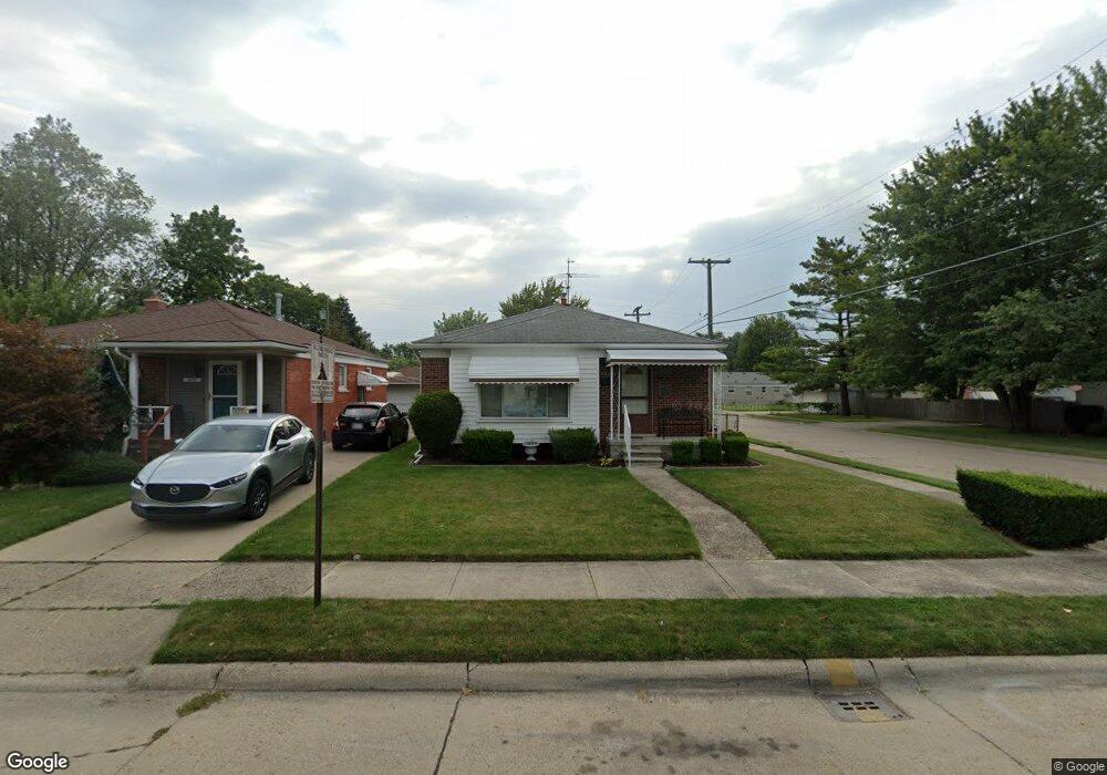
24704 Cushing Ave Eastpointe, MI 48021
Estimated Value: $147,759 - $200,000
--
Bed
2
Baths
1,016
Sq Ft
$164/Sq Ft
Est. Value
About This Home
This home is located at 24704 Cushing Ave, Eastpointe, MI 48021 and is currently estimated at $166,940, approximately $164 per square foot. 24704 Cushing Ave is a home located in Macomb County with nearby schools including Forest Park Elementary School, Eastpointe Middle School, and Reach Charter Academy.
Ownership History
Date
Name
Owned For
Owner Type
Purchase Details
Closed on
Sep 30, 2016
Sold by
Tomasello Paul B and Tomasello Janine A
Bought by
Liberties Management Corp
Current Estimated Value
Purchase Details
Closed on
Aug 31, 2003
Sold by
Tomasello Paul B and Tomasello Janine A
Bought by
Tomasello Paul B and Tomasello Janine A
Home Financials for this Owner
Home Financials are based on the most recent Mortgage that was taken out on this home.
Original Mortgage
$103,200
Interest Rate
6.23%
Mortgage Type
Purchase Money Mortgage
Create a Home Valuation Report for This Property
The Home Valuation Report is an in-depth analysis detailing your home's value as well as a comparison with similar homes in the area
Home Values in the Area
Average Home Value in this Area
Purchase History
| Date | Buyer | Sale Price | Title Company |
|---|---|---|---|
| Liberties Management Corp | $20,000 | None Available | |
| Tomasello Paul B | -- | Chicago Title Insurance Co |
Source: Public Records
Mortgage History
| Date | Status | Borrower | Loan Amount |
|---|---|---|---|
| Previous Owner | Tomasello Paul B | $103,200 |
Source: Public Records
Tax History Compared to Growth
Tax History
| Year | Tax Paid | Tax Assessment Tax Assessment Total Assessment is a certain percentage of the fair market value that is determined by local assessors to be the total taxable value of land and additions on the property. | Land | Improvement |
|---|---|---|---|---|
| 2025 | $3,567 | $80,000 | $0 | $0 |
| 2024 | $2,851 | $75,800 | $0 | $0 |
| 2023 | $2,611 | $68,900 | $0 | $0 |
| 2022 | $2,911 | $58,300 | $0 | $0 |
| 2021 | $1,977 | $51,100 | $0 | $0 |
| 2020 | $1,888 | $46,500 | $0 | $0 |
| 2019 | $2,738 | $38,600 | $0 | $0 |
| 2018 | $2,449 | $33,810 | $0 | $0 |
| 2017 | $2,583 | $31,280 | $3,210 | $28,070 |
| 2016 | $2,273 | $31,280 | $0 | $0 |
| 2015 | $1,393 | $27,660 | $0 | $0 |
| 2013 | $1,510 | $27,110 | $0 | $0 |
Source: Public Records
Map
Nearby Homes
- 24656 Dwight Ave
- 24707 Saxony Ave
- 17225 Bell Ave
- 17121 Wilson Ave
- 24676 Lambrecht Ave
- 16923 Stephens Dr
- 24646 Tuscany Ave
- 24267 Shakespeare Ave
- 16841 Stephens Dr
- 17100 Stephens Dr
- 24300 Melrose Ave
- 24924 Tuscany Ave
- 24228 Melrose Ave
- 24245 Tuscany Ave
- 25124 Blair St
- 16619 Waterman Dr
- 23735 Donald Ave
- 25171 Lawn St
- 16123 Bell Ave
- 23703 Donald Ave
- 24712 Cushing Ave Unit Bldg-Unit
- 24712 Cushing Ave
- 24711 Dwight Ave
- 24720 Cushing Ave
- 24690 Cushing Ave
- 24701 Dwight Ave
- 24728 Cushing Ave
- 24731 Dwight Ave
- 16953 Hauss Ave
- 24721 Dwight Ave
- 24738 Cushing Ave
- 24682 Cushing Ave
- 24741 Dwight Ave
- 24674 Cushing Ave
- 24691 Dwight Ave
- 24748 Cushing Ave
- 16943 Hauss Ave
- 24671 Dwight Ave
- 24681 Dwight Ave
- 24666 Cushing Ave