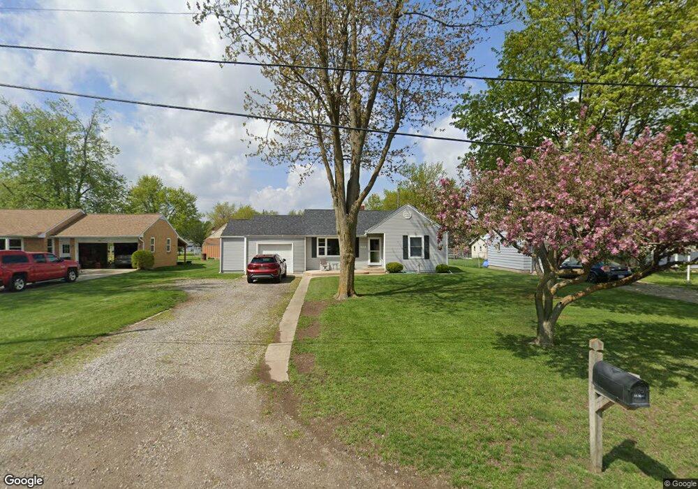
2472 Airport Rd Adrian, MI 49221
Estimated Value: $165,000 - $195,000
2
Beds
1
Bath
944
Sq Ft
$191/Sq Ft
Est. Value
About This Home
This home is located at 2472 Airport Rd, Adrian, MI 49221 and is currently estimated at $180,725, approximately $191 per square foot. 2472 Airport Rd is a home located in Lenawee County with nearby schools including Adrian High School, Berean Baptist Academy, and St. Stephen Lutheran School.
Ownership History
Date
Name
Owned For
Owner Type
Purchase Details
Closed on
Mar 16, 2020
Sold by
Swartz Sandra L
Bought by
Swartz Richard D
Current Estimated Value
Purchase Details
Closed on
Jul 22, 2014
Sold by
Swartz Richard D and Kopka Sue
Bought by
Swartz Richard D and Swartz Sandra
Home Financials for this Owner
Home Financials are based on the most recent Mortgage that was taken out on this home.
Original Mortgage
$60,800
Interest Rate
4.15%
Mortgage Type
New Conventional
Purchase Details
Closed on
Aug 31, 1999
Bought by
Swartz Richard D and Sue Kopka
Create a Home Valuation Report for This Property
The Home Valuation Report is an in-depth analysis detailing your home's value as well as a comparison with similar homes in the area
Home Values in the Area
Average Home Value in this Area
Purchase History
| Date | Buyer | Sale Price | Title Company |
|---|---|---|---|
| Swartz Richard D | -- | None Available | |
| Swartz Richard D | -- | American Title Co Of Lenawee | |
| Swartz Richard D | -- | -- |
Source: Public Records
Mortgage History
| Date | Status | Borrower | Loan Amount |
|---|---|---|---|
| Previous Owner | Swartz Richard D | $60,800 | |
| Previous Owner | Swartz Richard D | $15,200 |
Source: Public Records
Tax History Compared to Growth
Tax History
| Year | Tax Paid | Tax Assessment Tax Assessment Total Assessment is a certain percentage of the fair market value that is determined by local assessors to be the total taxable value of land and additions on the property. | Land | Improvement |
|---|---|---|---|---|
| 2025 | $1,504 | $75,800 | $0 | $0 |
| 2024 | $869 | $69,600 | $0 | $0 |
| 2022 | $787 | $53,000 | $0 | $0 |
| 2021 | $1,369 | $51,200 | $0 | $0 |
| 2020 | $1,367 | $51,800 | $0 | $0 |
| 2019 | $114,871 | $45,700 | $0 | $0 |
| 2018 | $1,326 | $45,739 | $0 | $0 |
| 2017 | $1,241 | $42,087 | $0 | $0 |
| 2016 | $1,488 | $40,287 | $0 | $0 |
| 2014 | -- | $38,295 | $0 | $0 |
Source: Public Records
Map
Nearby Homes
- 2682 Elmwood Dr
- 2015 Green Acres Dr
- 2018 Green Acres Dr
- 2029 Green Acres Dr
- 2023 Green Acres Dr
- 2027 Green Acres Dr
- 2012 Green Acres Dr
- 2010 Green Acres Dr
- 2008 Green Acres Dr
- 1692 Rivers Edge Ct
- 1902 W Cadmus Rd
- 1639 Rivers Edge Ct
- 302 Lakewood Dr
- 802 Lakewood Dr
- 1227 Sherman St
- 301 Ohio River Dr Unit LOT 52
- 3520 Crestone Way
- 1035 Scottdale Dr
- 421 S Madison St
- 1136 Michigan Ave
- 2471 Airport Rd
- 2476 Airport Rd
- 2456 Airport Rd
- 2459 Airport Rd
- 2446 Airport Rd
- 2497 Airport Rd
- 2501 Airport Rd
- 2443 Airport Rd
- 2400 Airport Rd
- 2411 Airport Rd
- 2439 Airport Rd
- 2396 Airport Rd
- 2417 E Clearview Dr
- 2486 Airport Rd
- 2390 Airport Rd
- 2416 E Clearview Dr
- 2416 E Clearview Dr Unit 2416 Clearview
- 2511 Airport Rd
- 2386 Airport Rd
- 2592 Elmwood Dr