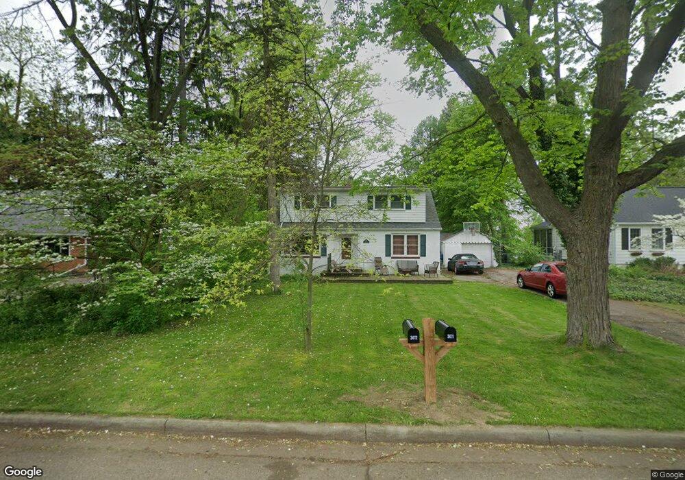
2472 Grant Dr Ann Arbor, MI 48108
Estimated Value: $294,000 - $408,000
4
Beds
3
Baths
1,914
Sq Ft
$193/Sq Ft
Est. Value
About This Home
This home is located at 2472 Grant Dr, Ann Arbor, MI 48108 and is currently estimated at $368,989, approximately $192 per square foot. 2472 Grant Dr is a home located in Washtenaw County with nearby schools including Carpenter Elementary School, Scarlett Middle School, and Huron High School.
Ownership History
Date
Name
Owned For
Owner Type
Purchase Details
Closed on
May 9, 2018
Sold by
Wilkins Timario J
Bought by
Wilkins Leslie A
Current Estimated Value
Home Financials for this Owner
Home Financials are based on the most recent Mortgage that was taken out on this home.
Original Mortgage
$188,000
Outstanding Balance
$161,874
Interest Rate
4.4%
Estimated Equity
$207,115
Purchase Details
Closed on
Jan 26, 2007
Sold by
Amann Peter
Bought by
Mchenry Earl E and Mchenry Beryl E
Create a Home Valuation Report for This Property
The Home Valuation Report is an in-depth analysis detailing your home's value as well as a comparison with similar homes in the area
Home Values in the Area
Average Home Value in this Area
Purchase History
| Date | Buyer | Sale Price | Title Company |
|---|---|---|---|
| Wilkins Leslie A | -- | None Available | |
| Wilkins Timario J | $196,000 | None Available | |
| Mchenry Earl E | $194,000 | American Title Co Livingston |
Source: Public Records
Mortgage History
| Date | Status | Borrower | Loan Amount |
|---|---|---|---|
| Open | Wilkins Leslie A | $188,000 |
Source: Public Records
Tax History Compared to Growth
Tax History
| Year | Tax Paid | Tax Assessment Tax Assessment Total Assessment is a certain percentage of the fair market value that is determined by local assessors to be the total taxable value of land and additions on the property. | Land | Improvement |
|---|---|---|---|---|
| 2025 | $3,495 | $170,336 | $0 | $0 |
| 2024 | $2,338 | $157,873 | $0 | $0 |
| 2023 | $2,246 | $128,700 | $0 | $0 |
| 2022 | $3,379 | $129,500 | $0 | $0 |
| 2021 | $3,289 | $116,300 | $0 | $0 |
| 2020 | $3,227 | $120,600 | $0 | $0 |
| 2019 | $3,056 | $104,100 | $104,100 | $0 |
| 2018 | $3,004 | $98,500 | $0 | $0 |
| 2017 | $2,908 | $98,000 | $0 | $0 |
| 2016 | $1,867 | $73,419 | $0 | $0 |
| 2015 | -- | $73,200 | $0 | $0 |
| 2014 | -- | $71,358 | $0 | $0 |
| 2013 | -- | $71,358 | $0 | $0 |
Source: Public Records
Map
Nearby Homes
- 2514 Carlton Dr
- 6 Salem Ct
- 2525 Yost Blvd
- 2460 Yost Blvd
- 2707 Brandywine Dr
- 2310 Pinecrest Ave
- 3455 Richard St
- 3457 Richard St
- 3436 Edgewood Dr
- 3425 Norwood St
- 3099 Village Cir Unit 52
- 2839 Whitewood St
- 1690 Meadowside Dr
- 3480 Wooddale Ct
- 2468 Fernwood Ave
- 2832 Pittsfield Blvd Unit 139
- 2562 Fernwood Ave
- 3084 Turnberry Ln
- 3005 Fernwood Ave Unit 103
- 3325 Packard St