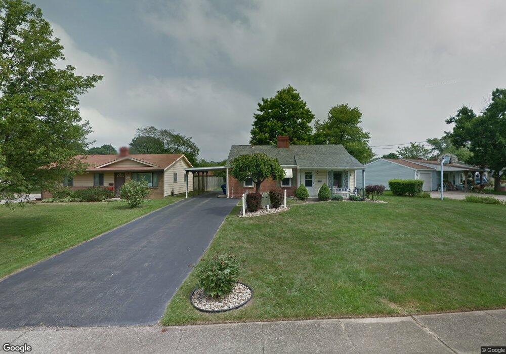
2475 Poplar St Girard, OH 44420
Estimated Value: $124,000 - $142,166
3
Beds
1
Bath
1,036
Sq Ft
$127/Sq Ft
Est. Value
About This Home
This home is located at 2475 Poplar St, Girard, OH 44420 and is currently estimated at $131,792, approximately $127 per square foot. 2475 Poplar St is a home located in Trumbull County with nearby schools including Girard Intermediate School, Prospect Elementary School, and Girard Junior High School.
Ownership History
Date
Name
Owned For
Owner Type
Purchase Details
Closed on
May 12, 2025
Sold by
Sees Marylyn J
Bought by
Sees Family Revocable Living Trust and Sees
Current Estimated Value
Purchase Details
Closed on
Oct 12, 2004
Sold by
Sees Donald D
Bought by
Sees Marilyn J
Purchase Details
Closed on
Oct 11, 2004
Sold by
Sees Donald D
Bought by
Sees Marilyn J
Purchase Details
Closed on
Jun 9, 1994
Bought by
Sees Donald D
Purchase Details
Closed on
Jan 1, 1990
Bought by
Patrick A Johns
Create a Home Valuation Report for This Property
The Home Valuation Report is an in-depth analysis detailing your home's value as well as a comparison with similar homes in the area
Home Values in the Area
Average Home Value in this Area
Purchase History
| Date | Buyer | Sale Price | Title Company |
|---|---|---|---|
| Sees Family Revocable Living Trust | -- | None Listed On Document | |
| Sees Marilyn J | -- | -- | |
| Sees Marilyn J | -- | -- | |
| Sees Donald D | $52,900 | -- | |
| Patrick A Johns | -- | -- |
Source: Public Records
Tax History Compared to Growth
Tax History
| Year | Tax Paid | Tax Assessment Tax Assessment Total Assessment is a certain percentage of the fair market value that is determined by local assessors to be the total taxable value of land and additions on the property. | Land | Improvement |
|---|---|---|---|---|
| 2024 | $983 | $31,190 | $4,130 | $27,060 |
| 2023 | $983 | $31,190 | $4,130 | $27,060 |
| 2022 | $753 | $22,860 | $4,130 | $18,730 |
| 2021 | $756 | $22,860 | $4,130 | $18,730 |
| 2020 | $1,215 | $22,860 | $4,130 | $18,730 |
| 2019 | $1,289 | $22,860 | $4,130 | $18,730 |
| 2018 | $1,351 | $22,860 | $4,130 | $18,730 |
| 2017 | $1,348 | $22,860 | $4,130 | $18,730 |
| 2016 | $1,347 | $22,020 | $4,130 | $17,890 |
| 2015 | $1,343 | $22,020 | $4,130 | $17,890 |
| 2014 | $1,337 | $22,020 | $4,130 | $17,890 |
| 2013 | $1,293 | $22,020 | $4,130 | $17,890 |
Source: Public Records
Map
Nearby Homes
- 2555 Walnut St
- 0 W Liberty Unit 5153649
- 2700 W Liberty St
- W Liberty St Unit LotWP001
- 2169 Salt Springs Rd
- 804 Texas Ave
- 3117 Youngstown Ave
- 3114 Youngstown Ave
- 3050 Trumbull Ave
- 4028 Lanterman Rd
- 412 Ohio Ave
- 522 Illinois Ave
- 2246 Ohltown McDonald Rd
- 403 W Liberty St
- 438 Hayes Ave
- 507 E 5th St
- 350 Grant St
- 2957 Greenfield Ave
- 1684 Morris St
- 1757 E County Line Rd
- 2467 Poplar St
- 2485 Poplar St
- 2491 Poplar St
- 3595 Oakview Dr
- 3629 Oakview Dr
- 2495 Poplar St
- 3589 Oakview Dr
- 3608 Oakview Dr
- 3614 Oakview Dr
- 2478 Poplar St
- 3602 Oakview Dr
- 2482 Poplar St
- 3620 Oakview Dr
- 2486 Poplar St
- 3637 Oakview Dr
- 3596 Oakview Dr
- 2499 Poplar St
- 2490 Poplar St
- 3626 Oakview Dr
- 3590 Oakview Dr