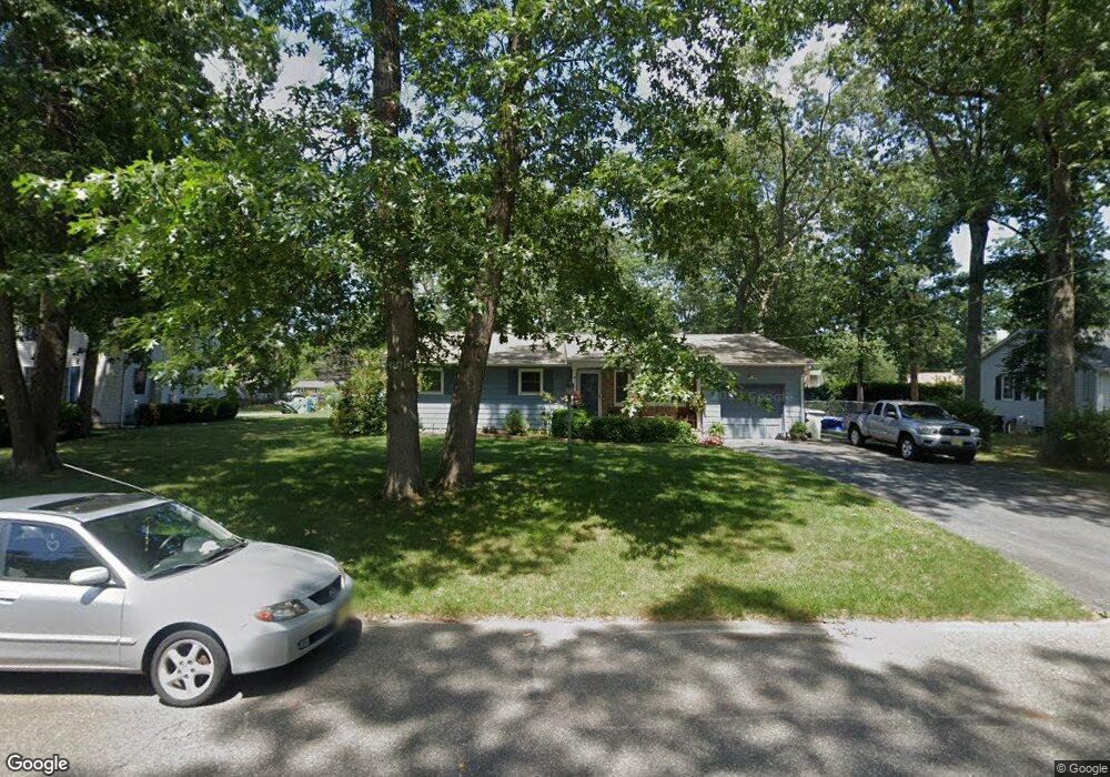
2475 Sanford Dr Vineland, NJ 08361
Estimated Value: $272,698 - $362,000
--
Bed
--
Bath
1,638
Sq Ft
$198/Sq Ft
Est. Value
About This Home
This home is located at 2475 Sanford Dr, Vineland, NJ 08361 and is currently estimated at $324,675, approximately $198 per square foot. 2475 Sanford Dr is a home located in Cumberland County with nearby schools including Anthony Rossi Elementary School, John H. Winslow Elementary School, and Vineland Senior High School.
Ownership History
Date
Name
Owned For
Owner Type
Purchase Details
Closed on
Jul 27, 1994
Sold by
Staropoli Joseph J
Bought by
Palau Michael A and Palau Jacqueline Ann
Current Estimated Value
Purchase Details
Closed on
Apr 29, 1994
Sold by
Jerrell Winifred E
Bought by
Szumowski Michael J
Home Financials for this Owner
Home Financials are based on the most recent Mortgage that was taken out on this home.
Original Mortgage
$32,000
Interest Rate
7.7%
Create a Home Valuation Report for This Property
The Home Valuation Report is an in-depth analysis detailing your home's value as well as a comparison with similar homes in the area
Home Values in the Area
Average Home Value in this Area
Purchase History
| Date | Buyer | Sale Price | Title Company |
|---|---|---|---|
| Palau Michael A | $80,000 | -- | |
| Szumowski Michael J | $35,000 | -- |
Source: Public Records
Mortgage History
| Date | Status | Borrower | Loan Amount |
|---|---|---|---|
| Previous Owner | Szumowski Michael J | $32,000 |
Source: Public Records
Tax History Compared to Growth
Tax History
| Year | Tax Paid | Tax Assessment Tax Assessment Total Assessment is a certain percentage of the fair market value that is determined by local assessors to be the total taxable value of land and additions on the property. | Land | Improvement |
|---|---|---|---|---|
| 2025 | $4,716 | $148,100 | $33,400 | $114,700 |
| 2024 | $4,716 | $148,100 | $33,400 | $114,700 |
| 2023 | $4,684 | $148,100 | $33,400 | $114,700 |
| 2022 | $4,545 | $148,100 | $33,400 | $114,700 |
| 2021 | $4,462 | $148,100 | $33,400 | $114,700 |
| 2020 | $4,335 | $148,100 | $33,400 | $114,700 |
| 2019 | $4,276 | $148,100 | $33,400 | $114,700 |
| 2018 | $4,163 | $148,100 | $33,400 | $114,700 |
| 2017 | $3,954 | $148,100 | $33,400 | $114,700 |
| 2016 | $3,815 | $148,100 | $33,400 | $114,700 |
| 2015 | $3,674 | $148,100 | $33,400 | $114,700 |
| 2014 | $3,474 | $148,100 | $33,400 | $114,700 |
Source: Public Records
Map
Nearby Homes
- 3773 Brookhaven Dr
- 3391 Venturi Ln
- 2151 S Brookfield St
- 3176 Hance Bridge Rd
- 1880 S Brookfield St
- 2851 Crane St
- 2769 Dante Ave
- 1535 Bear Branch Ct
- 4024 Renee Dr
- 2603 Valhalla Rd
- 4437 Juniper St
- 2676 Medina St
- 0 Ascher Rd
- 4517 Ascher Rd
- 2564 Edna Dr
- 2551 Edna Dr
- 2671 E Sherman Ave
- 1730 Junior Dr
- 2354 Dante Ave
- 1197 S Lincoln Ave
- 2463 Sanford Dr
- 2489 Sanford Dr
- 2432 Brookhaven Dr
- 2448 Brookhaven Dr
- 2449 Sanford Dr
- 2468 Brookhaven Dr
- 2420 Brookhaven Dr
- 2482 Sanford Dr
- 2488 Brookhaven Dr
- 2492 Sanford Dr
- 2470 Sanford Dr
- 2406 Brookhaven Dr
- 2437 Sanford Dr
- 2456 Sanford Dr
- 2500 Sanford Dr
- 2394 Brookhaven Dr
- 2506 Sanford Dr
- 2444 Sanford Dr
- 2449 Brookhaven Dr
- 2521 Venezia Ave