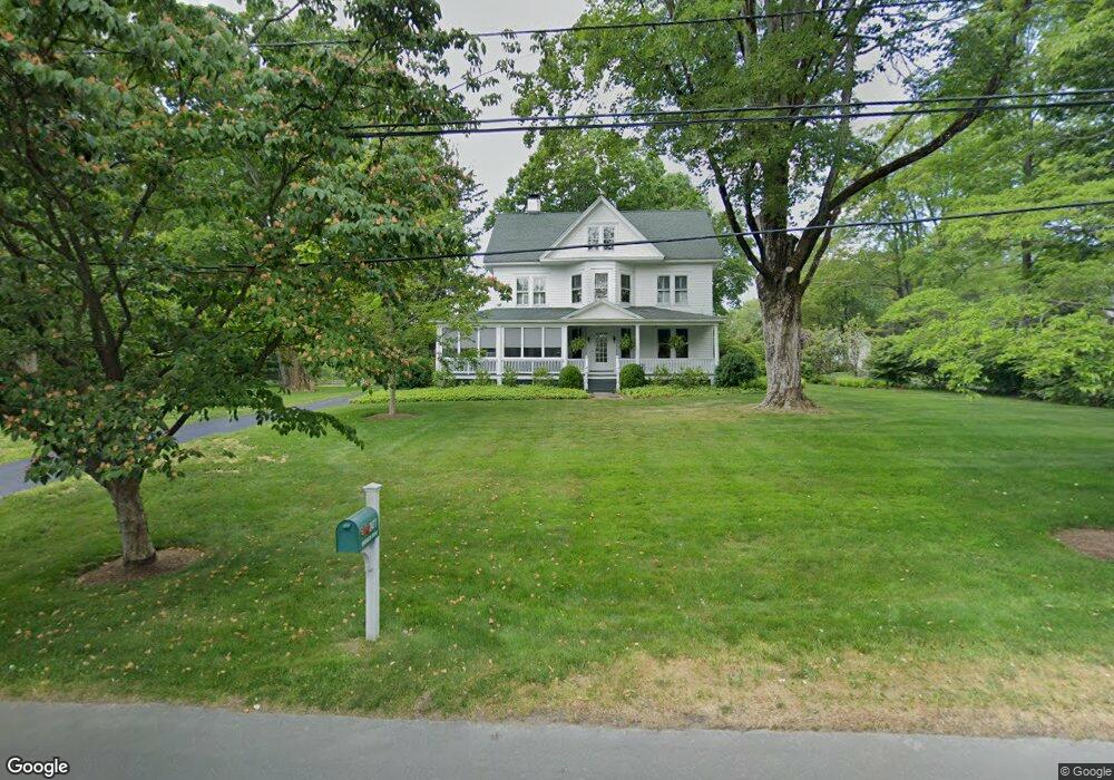
2477 Bronson Rd Fairfield, CT 06824
Greenfield Hill NeighborhoodEstimated Value: $1,394,000 - $1,921,000
3
Beds
3
Baths
2,687
Sq Ft
$598/Sq Ft
Est. Value
About This Home
This home is located at 2477 Bronson Rd, Fairfield, CT 06824 and is currently estimated at $1,607,066, approximately $598 per square foot. 2477 Bronson Rd is a home located in Fairfield County with nearby schools including Dwight Elementary School, Roger Ludlowe Middle School, and Fairfield Ludlowe High School.
Ownership History
Date
Name
Owned For
Owner Type
Purchase Details
Closed on
Nov 20, 2009
Sold by
Hobbie Robert J
Bought by
Hobbie Joyce W
Current Estimated Value
Create a Home Valuation Report for This Property
The Home Valuation Report is an in-depth analysis detailing your home's value as well as a comparison with similar homes in the area
Home Values in the Area
Average Home Value in this Area
Purchase History
| Date | Buyer | Sale Price | Title Company |
|---|---|---|---|
| Hobbie Joyce W | -- | -- | |
| Hobbie Joyce W | -- | -- | |
| Hobbie Joyce W | -- | -- |
Source: Public Records
Mortgage History
| Date | Status | Borrower | Loan Amount |
|---|---|---|---|
| Open | Hobbie Joyce W | $800,000 |
Source: Public Records
Tax History
| Year | Tax Paid | Tax Assessment Tax Assessment Total Assessment is a certain percentage of the fair market value that is determined by local assessors to be the total taxable value of land and additions on the property. | Land | Improvement |
|---|---|---|---|---|
| 2025 | $17,528 | $617,400 | $367,570 | $249,830 |
| 2024 | $17,225 | $617,400 | $367,570 | $249,830 |
| 2023 | $16,985 | $617,400 | $367,570 | $249,830 |
| 2022 | $16,818 | $617,400 | $367,570 | $249,830 |
| 2021 | $16,657 | $617,400 | $367,570 | $249,830 |
| 2020 | $19,499 | $727,860 | $445,690 | $282,170 |
| 2019 | $19,499 | $727,860 | $445,690 | $282,170 |
| 2018 | $19,186 | $727,860 | $445,690 | $282,170 |
| 2017 | $18,793 | $727,860 | $445,690 | $282,170 |
| 2016 | $18,524 | $727,860 | $445,690 | $282,170 |
| 2015 | $18,727 | $755,440 | $503,090 | $252,350 |
| 2014 | $18,433 | $755,440 | $503,090 | $252,350 |
Source: Public Records
Map
Nearby Homes
- 2683 Bronson Rd
- 688 Hulls Farm Rd
- 1380 Old Academy Rd
- 110 Queens Grant Dr
- 360 Duck Farm Rd
- 148 Millspaugh Dr
- 1 Sturges Hwy Unit 2
- 218 Lower Farm Rd
- 1353 Mill Plain Rd
- 3674 Congress St
- 10 Debra Ln
- 21 Sturges Commons
- 647 Bronson Rd
- 1091 Round Hill Rd
- 53 Hilltop Dr
- 2177 Cross Hwy
- 153 Pease Ave
- 3 Hunt Club Ln
- 329 Bronson Rd
- 107 Old Rd
- 2505 Bronson Rd
- 2502 Bronson Rd
- 2444 Bronson Rd
- 2527 Bronson Rd
- 2419 Bronson Rd
- 2424 Bronson Rd
- 2569 Bronson Rd
- 2360 Bronson Rd
- 310 Governors Ln
- 2347 Bronson Rd
- 190 Redding Rd
- 2615 Bronson Rd
- 253 Redding Rd
- 158 Redding Rd
- 190 Governors Ln
- 424 Redding Rd
- 2300 Bronson Rd
- 2641 Bronson Rd
- 2644 Bronson Rd
- 120 Redding Rd
Your Personal Tour Guide
Ask me questions while you tour the home.