Estimated Value: $78,000 - $93,213
3
Beds
2
Baths
1,550
Sq Ft
$55/Sq Ft
Est. Value
About This Home
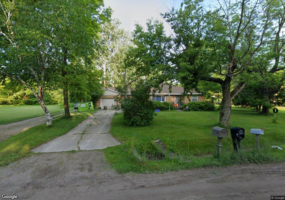
This home is located at 2477 Thornton Ave, Flint, MI 48504 and is currently estimated at $85,053, approximately $54 per square foot. 2477 Thornton Ave is a home located in Genesee County with nearby schools including Carman-Ainsworth High School, Greater Heights Academy, and Eagle's Nest Academy.
Ownership History
Date
Name
Owned For
Owner Type
Purchase Details
Closed on
Dec 15, 2005
Sold by
Gibson Joyce A
Bought by
Penfold Bernard W and Penfold Connie M
Current Estimated Value
Home Financials for this Owner
Home Financials are based on the most recent Mortgage that was taken out on this home.
Original Mortgage
$88,000
Outstanding Balance
$49,383
Interest Rate
6.34%
Mortgage Type
New Conventional
Estimated Equity
$35,670
Purchase Details
Closed on
Jun 6, 2001
Sold by
French William C
Bought by
Gibson Joyce A
Create a Home Valuation Report for This Property
The Home Valuation Report is an in-depth analysis detailing your home's value as well as a comparison with similar homes in the area
Home Values in the Area
Average Home Value in this Area
Purchase History
| Date | Buyer | Sale Price | Title Company |
|---|---|---|---|
| Penfold Bernard W | $110,000 | Multiple | |
| Gibson Joyce A | -- | -- |
Source: Public Records
Mortgage History
| Date | Status | Borrower | Loan Amount |
|---|---|---|---|
| Open | Penfold Bernard W | $88,000 |
Source: Public Records
Tax History Compared to Growth
Tax History
| Year | Tax Paid | Tax Assessment Tax Assessment Total Assessment is a certain percentage of the fair market value that is determined by local assessors to be the total taxable value of land and additions on the property. | Land | Improvement |
|---|---|---|---|---|
| 2025 | $1,267 | $31,100 | $0 | $0 |
| 2024 | $584 | $31,700 | $0 | $0 |
| 2023 | $558 | $30,200 | $0 | $0 |
| 2022 | $574 | $24,900 | $0 | $0 |
| 2021 | $1,086 | $22,900 | $0 | $0 |
| 2020 | $537 | $24,200 | $0 | $0 |
| 2019 | $532 | $23,900 | $0 | $0 |
| 2018 | $1,239 | $29,800 | $0 | $0 |
| 2017 | $1,265 | $29,800 | $0 | $0 |
| 2016 | $1,301 | $29,400 | $0 | $0 |
| 2015 | $1,128 | $29,500 | $0 | $0 |
| 2014 | $669 | $28,300 | $0 | $0 |
| 2012 | -- | $44,400 | $44,400 | $0 |
Source: Public Records
Map
Nearby Homes
- 2214 Mack Ave
- 2565 Mccollum Ave
- 2495 Lavelle Rd
- 2631 Brownell Blvd
- 2407 Kellar Ave
- 1713 W Dartmouth St
- 3310 Concord St
- 2615 Trumbull Ave
- 2907 Trumbull Ave
- 3084 Roanoke St
- 2299 Lavelle Rd
- 3617 Kellar Ave
- 1521 W Dartmouth St
- 3412 Comstock Ave
- 1705 W Pasadena Ave
- 3021 Clement St
- 1402 W Dartmouth St
- 2952 Clement St
- 3145 Raywood St
- 3819 Brownell Blvd
- 2489 Thornton Ave
- 2455 Thornton Ave
- 2465 Thornton Ave
- 2497 Thornton Ave
- 2484 Thornton Ave
- 2474 Bertha Ave
- 2470 Bertha Ave
- 2490 Bertha Ave
- 2488 Thornton Ave
- 2480 Thornton Ave
- 2494 Bertha Ave
- 2468 Thornton Ave
- 2460 Bertha Ave
- 2494 Thornton Ave
- 3043 W Dartmouth St
- 2445 Thornton Ave
- 3049 W Dartmouth St
- 2498 Thornton Ave
- 2448 Bertha Ave
- 2448 Thornton Ave