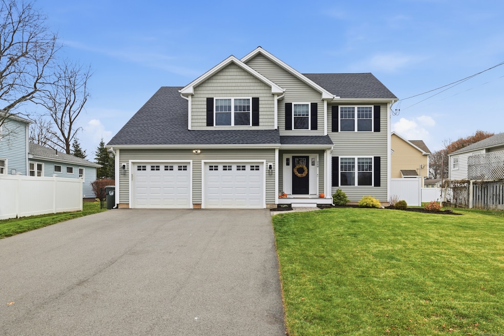
248 Maple Hill Ave Newington, CT 06111
Estimated payment $3,948/month
Highlights
- Colonial Architecture
- 2 Fireplaces
- Farmhouse Sink
- Attic
- Mud Room
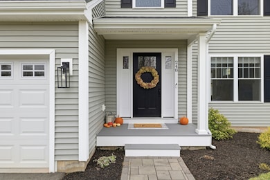
- Patio
About This Home
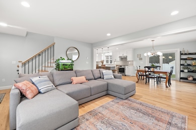
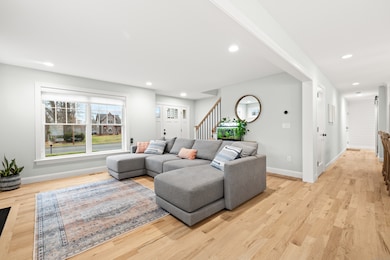
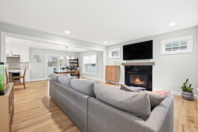
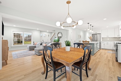
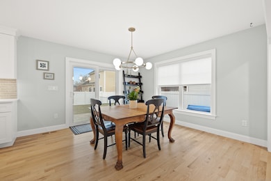
Rare find! A stunning, 2022-built Colonial! Welcome to 248 Maple Hill Road, where modern design and quality craftsmanship meets comfortable living. This gorgeous 3-bedroom, 2.5 bath home leaves nothing to be desired. From the moment you step inside, you'll fall in love with the bright, open-concept floor plan and thoughtful upgrades. The spacious living room features beautiful oak flooring that flows through the entire home, along with a gas-log fireplace that serves as the focal point. The living space seamlessly opens to a spacious dining area, with a sliding door that fills the room with natural light and leads to the fully fenced backyard and patio. The dining area connects effortlessly to the stunning gourmet kitchen. Home chefs will appreciate the oversized island, quartz countertops, ample seating and storage. Additional highlights include a farmhouse sink, tile backsplash, and a large pantry. A convenient mudroom and chic powder room complete the first floor. Upstairs, you'll find three generously sized bedrooms, including a beautiful owner's suite. The suite features a luxurious full bath with double vanities and an enormous walk-in closet. A dedicated laundry room and an additional full bathroom add to the second floor's functionality. The finished basement provides even more living space-ideal for a family room, home office, gym, or playroom. Even more added features include gas utilities, Central Air, and a 2-car attached garage. A must see!
Listing Agent
Berkshire Hathaway NE Prop. Brokerage Phone: (860) 983-0748 License #RES.0790822 Listed on: 12/04/2025

Home Details
Home Type
- Single Family
Est. Annual Taxes
- $10,162
Year Built
- Built in 2022
Lot Details
- 7,405 Sq Ft Lot
- Property is zoned R-12
Home Design
- Colonial Architecture
- Concrete Foundation
- Frame Construction
- Asphalt Shingled Roof
- Vinyl Siding
Interior Spaces
- Sound System
- 2 Fireplaces
- Mud Room
- Walkup Attic
Kitchen
- Gas Range
- Range Hood
- Microwave
- Dishwasher
- Farmhouse Sink
Bedrooms and Bathrooms
- 3 Bedrooms
Laundry
- Laundry Room
- Laundry on upper level
Partially Finished Basement
- Heated Basement
- Basement Fills Entire Space Under The House
Parking
- 2 Car Garage
- Automatic Garage Door Opener
Outdoor Features
- Patio
- Exterior Lighting
- Rain Gutters
Schools
- Newington High School
Utilities
- Central Air
- Heating System Uses Natural Gas
Listing and Financial Details
- Assessor Parcel Number 664241
Map
Home Values in the Area
Average Home Value in this Area
Tax History
| Year | Tax Paid | Tax Assessment Tax Assessment Total Assessment is a certain percentage of the fair market value that is determined by local assessors to be the total taxable value of land and additions on the property. | Land | Improvement |
|---|---|---|---|---|
| 2025 | $10,162 | $254,180 | $52,420 | $201,760 |
| 2024 | $10,083 | $254,180 | $52,420 | $201,760 |
| 2023 | $9,750 | $254,180 | $52,420 | $201,760 |
| 2022 | $2,578 | $66,970 | $52,420 | $14,550 |
| 2021 | $5,286 | $136,210 | $52,420 | $83,790 |
| 2020 | $5,259 | $133,890 | $50,400 | $83,490 |
| 2019 | $5,282 | $133,890 | $50,400 | $83,490 |
| 2018 | $5,155 | $133,890 | $50,400 | $83,490 |
| 2017 | $4,899 | $133,890 | $50,400 | $83,490 |
| 2016 | $4,787 | $133,890 | $50,400 | $83,490 |
| 2014 | $4,558 | $131,100 | $51,650 | $79,450 |
Property History
| Date | Event | Price | List to Sale | Price per Sq Ft |
|---|---|---|---|---|
| 12/04/2025 12/04/25 | For Sale | $589,000 | -- | $223 / Sq Ft |
Purchase History
| Date | Type | Sale Price | Title Company |
|---|---|---|---|
| Warranty Deed | $100,000 | None Available | |
| Warranty Deed | $170,000 | -- |
Mortgage History
| Date | Status | Loan Amount | Loan Type |
|---|---|---|---|
| Open | $320,000 | Purchase Money Mortgage |
Source: SmartMLS
MLS Number: 24142934
APN: NEWI-000015-000128-A000000
Disclaimer: Certain information contained herein is derived from information provided by parties other than Homes.com. All information provided is deemed reliable, but is not guaranteed to be accurate and should be independently verified.
![]() IDX information is provided exclusively for personal, non-commercial use, and may not be used for any purpose other than to identify prospective properties consumers may be interested in purchasing. Information is deemed reliable but not guaranteed.
IDX information is provided exclusively for personal, non-commercial use, and may not be used for any purpose other than to identify prospective properties consumers may be interested in purchasing. Information is deemed reliable but not guaranteed.
- 13 Standard St
- 212 Maple Hill Ave
- 18 Old Musket Dr
- 340 Robbins Ave
- 79 Lantern Hill
- 263 Robbins Ave
- 7 Old Farm Dr
- 9 Old Farm Dr
- 760 Willard Ave
- 1259 East St Unit A
- 1251 East St Unit F
- 133 Robbins Ave
- 21 7th St
- 1243 East St Unit F
- 11 Eleanor Place
- 37 Recano Rd
- 129 Glenview Dr
- 34 Beacon St
- 227 Amherst St
- 64 Garfield St
- 92 Indian Hill Rd
- 208 Buena Vista Ave
- 1317 East St
- 133 Robbins Ave
- 38 Beacon St Unit 38A2
- 60 Judd Ave
- 1431 Willard Ave
- 34 New Britain Ave
- 112 Market St Unit A
- 151 Newington Ave Unit 7B
- 96 Ledgecrest Ave
- 328 Chapman St
- 11 King Arthur's Way
- 215-265 Lowrey Place
- 162 Jubilee St Unit 2
- 30 Long St
- 30 Long St
- 1570 Willard Ave
- 1771 Stanley St
- 189 Daly Ave Unit First Floor - 3 BR