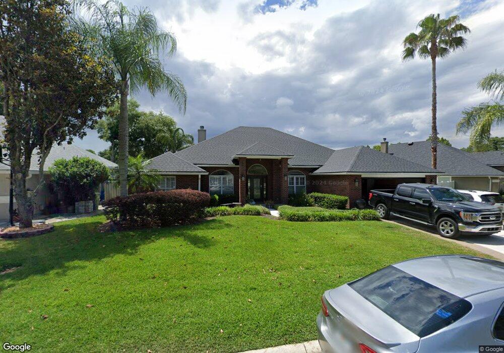
248 Sparrow Branch Cir Saint Johns, FL 32259
Estimated Value: $627,000 - $673,612
5
Beds
4
Baths
3,026
Sq Ft
$214/Sq Ft
Est. Value
About This Home
This home is located at 248 Sparrow Branch Cir, Saint Johns, FL 32259 and is currently estimated at $648,653, approximately $214 per square foot. 248 Sparrow Branch Cir is a home located in St. Johns County with nearby schools including Durbin Creek Elementary School, Fruit Cove Middle School, and Creekside High School.
Ownership History
Date
Name
Owned For
Owner Type
Purchase Details
Closed on
Feb 11, 2015
Sold by
Carter Wendi R and Carter Clinton W
Bought by
Carter Wendi R
Current Estimated Value
Purchase Details
Closed on
Jul 30, 2003
Sold by
Tousa Homes Inc
Bought by
Carter Clinton W and Carter Wendi R
Home Financials for this Owner
Home Financials are based on the most recent Mortgage that was taken out on this home.
Original Mortgage
$224,235
Interest Rate
8.35%
Mortgage Type
Purchase Money Mortgage
Create a Home Valuation Report for This Property
The Home Valuation Report is an in-depth analysis detailing your home's value as well as a comparison with similar homes in the area
Home Values in the Area
Average Home Value in this Area
Purchase History
| Date | Buyer | Sale Price | Title Company |
|---|---|---|---|
| Carter Wendi R | -- | None Available | |
| Carter Clinton W | $249,200 | First American |
Source: Public Records
Mortgage History
| Date | Status | Borrower | Loan Amount |
|---|---|---|---|
| Open | Carter Clinton W | $224,235 |
Source: Public Records
Tax History Compared to Growth
Tax History
| Year | Tax Paid | Tax Assessment Tax Assessment Total Assessment is a certain percentage of the fair market value that is determined by local assessors to be the total taxable value of land and additions on the property. | Land | Improvement |
|---|---|---|---|---|
| 2025 | $4,879 | $339,421 | -- | -- |
| 2024 | $4,879 | $329,855 | -- | -- |
| 2023 | $4,879 | $320,248 | $0 | $0 |
| 2022 | $4,773 | $310,920 | $0 | $0 |
| 2021 | $4,543 | $301,864 | $0 | $0 |
| 2020 | $4,482 | $297,696 | $0 | $0 |
| 2019 | $4,553 | $291,003 | $0 | $0 |
| 2018 | $4,472 | $285,577 | $0 | $0 |
| 2017 | $4,430 | $279,703 | $0 | $0 |
| 2016 | $4,411 | $282,168 | $0 | $0 |
| 2015 | $4,419 | $270,497 | $0 | $0 |
| 2014 | $4,315 | $259,357 | $0 | $0 |
Source: Public Records
Map
Nearby Homes
- 2708 Caldar Ct
- 300 Sparrow Branch Cir
- 4340 Rye Ct
- 969 W Tennessee Trace
- 4505 S Pennycress Place
- 527 Pine Haven Dr
- 648 E Tropical Trace
- 4160 Lonicera Loop
- 1821 W Windy Way
- 1001 Andrea Way
- 215 Carina Trail
- 200 Huntston Way
- 572 Sparrow Branch Cir
- 252 Pine Haven Dr
- 1121 Andrea Way
- 328 Welbeck Place
- 48 Pavia Place
- 105 Castlegate Ln
- 200 Gladstone Ct
- 1925 Barham Ct
- 252 Sparrow Branch Cir
- 240 Sparrow Branch Cir
- 256 Sparrow Branch Cir
- 232 Sparrow Branch Cir
- 249 Sparrow Branch Cir
- 253 Sparrow Branch Cir
- 245 Sparrow Branch Cir
- 241 Sparrow Branch Cir
- 260 Sparrow Branch Cir
- 257 Sparrow Branch Cir
- 228 Sparrow Branch Cir
- 237 Sparrow Branch Cir
- 233 Sparrow Branch Cir
- 261 Sparrow Branch Cir
- 264 Sparrow Branch Cir
- 229 Sparrow Branch Cir
- 4052 Lonicera Loop
- 220 Sparrow Branch Cir
- 265 Sparrow Branch Cir
- 3312 Pepper Ct