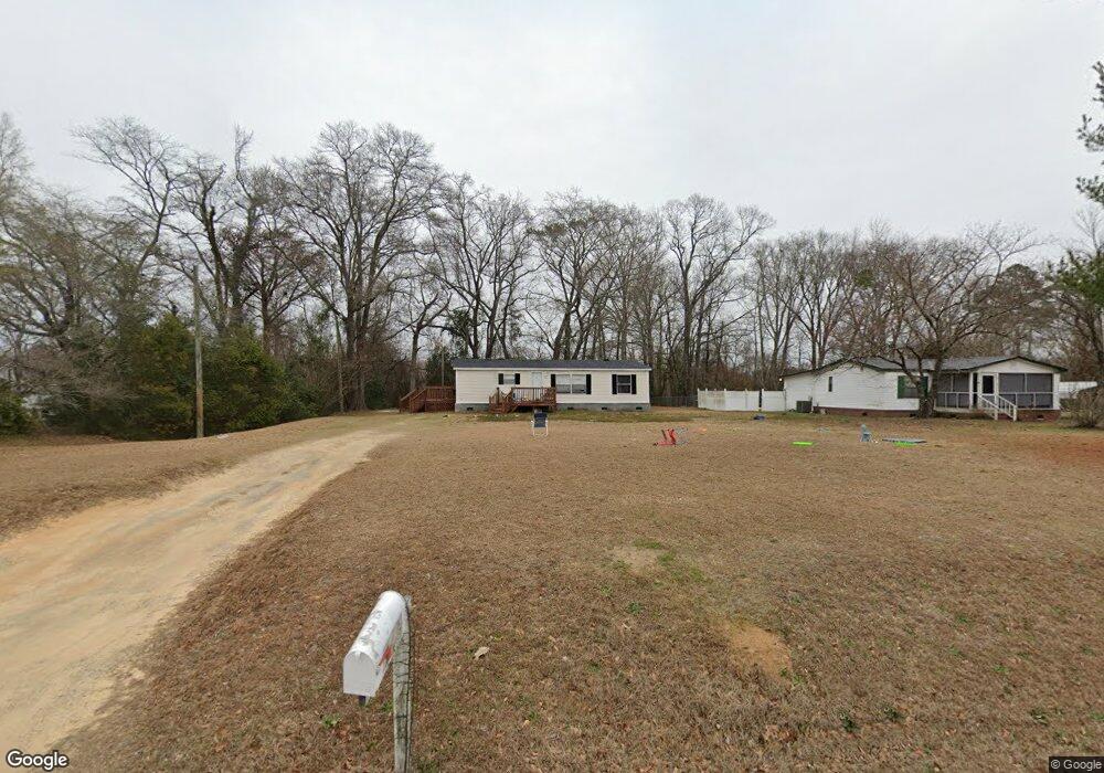
2484 Lindfield Cir Effingham, SC 29541
Estimated Value: $67,000 - $156,000
3
Beds
2
Baths
1,344
Sq Ft
$84/Sq Ft
Est. Value
About This Home
This home is located at 2484 Lindfield Cir, Effingham, SC 29541 and is currently estimated at $112,803, approximately $83 per square foot. 2484 Lindfield Cir is a home located in Florence County with nearby schools including Savannah Grove Elementary School, Southside Middle School, and South Florence High School.
Ownership History
Date
Name
Owned For
Owner Type
Purchase Details
Closed on
Jul 9, 2014
Sold by
Musgrave Marijane L
Bought by
Powell Gabrielle Starr and Powell Jack William
Current Estimated Value
Home Financials for this Owner
Home Financials are based on the most recent Mortgage that was taken out on this home.
Original Mortgage
$44,086
Outstanding Balance
$34,735
Interest Rate
5.5%
Mortgage Type
FHA
Estimated Equity
$78,068
Purchase Details
Closed on
Nov 20, 2009
Sold by
Matthews Ronald J and Matthews Glenn R
Bought by
Musgrave Marijane L
Home Financials for this Owner
Home Financials are based on the most recent Mortgage that was taken out on this home.
Original Mortgage
$26,700
Interest Rate
4.92%
Mortgage Type
Purchase Money Mortgage
Purchase Details
Closed on
Aug 30, 2005
Sold by
Rbc Centura Bank
Bought by
Matthews Ronald J and Matthews Glenn R
Purchase Details
Closed on
Nov 12, 2004
Sold by
Sauls Allen W and Sauls Barbara
Bought by
Rbc Centura Bank
Create a Home Valuation Report for This Property
The Home Valuation Report is an in-depth analysis detailing your home's value as well as a comparison with similar homes in the area
Purchase History
| Date | Buyer | Sale Price | Title Company |
|---|---|---|---|
| Powell Gabrielle Starr | $44,900 | -- | |
| Musgrave Marijane L | $30,000 | -- | |
| Matthews Ronald J | $11,500 | -- | |
| Rbc Centura Bank | $6,500 | -- |
Source: Public Records
Mortgage History
| Date | Status | Borrower | Loan Amount |
|---|---|---|---|
| Open | Powell Gabrielle Starr | $44,086 | |
| Previous Owner | Musgrave Marijane L | $26,700 |
Source: Public Records
Tax History
| Year | Tax Paid | Tax Assessment Tax Assessment Total Assessment is a certain percentage of the fair market value that is determined by local assessors to be the total taxable value of land and additions on the property. | Land | Improvement |
|---|---|---|---|---|
| 2025 | $208 | $1,796 | $556 | $1,240 |
| 2024 | $188 | $1,796 | $556 | $1,240 |
| 2023 | $189 | $556 | $556 | $0 |
| 2022 | $338 | $556 | $556 | $0 |
| 2021 | $233 | $1,800 | $0 | $0 |
| 2020 | $306 | $1,800 | $0 | $0 |
| 2019 | $307 | $1,800 | $0 | $0 |
| 2018 | $273 | $1,800 | $0 | $0 |
| 2017 | $287 | $1,800 | $0 | $0 |
| 2016 | $128 | $1,210 | $0 | $0 |
| 2015 | $127 | $1,210 | $0 | $0 |
| 2014 | $119 | $0 | $0 | $0 |
Source: Public Records
Map
Nearby Homes
- 2235 Ashford Dr
- 1808 Taylor Ct
- 2001 Elaine Cir
- 1811 Meadow Green Place
- 1816 Meadow Green Place
- 0 State Road S-21-869
- 1717 Full Moon Rd
- 2101 W McCown Dr
- 1701 Tuxedo Junction Rd
- Off S Point Rd
- 1716 Furman Dr
- 2303 W McCown Dr
- 1814 Citadel St
- 2943 Wild Turkey Dr
- 2141 Elderberry Dr
- 1804 Woods Dr
- 1779 S Saint Anthony Ave
- 1905 Marsh Ave
- 2113 Sanderling Dr
- 2338 W McCown Dr
- 2478 Lindfield Cir
- 2491 Lindfield Cir
- 2481 Lindfield Cir
- 2490 Lindfield Cir
- 2475 Lindfield Cir
- 2472 Lindfield Cir
- 2492 Lindfield Cir
- 2499 Lindfield Cir
- 2494 Lindfield Cir
- 2496 Lindfield Cir
- 2466 Lindfield Cir
- 2498 Lindfield Cir Unit 82
- 2447 Lindfield Cir
- 0 Ashford Dr Unit 1225749
- 2445 Lindfield Cir
- 2400 Lindfield Cir
- 2439 Lindfield Cir
- 2454 Lindfield Cir
- 2408 Lindfield Cir
- 2450 Lindfield Cir
Your Personal Tour Guide
Ask me questions while you tour the home.