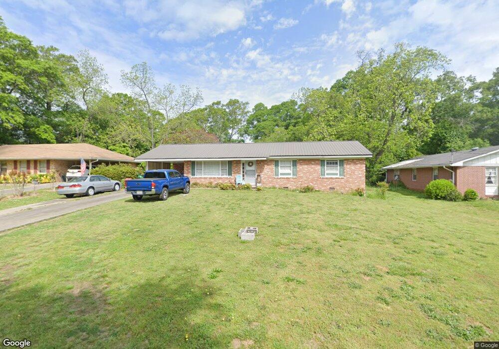
249 Sherwood Dr Winder, GA 30680
Estimated Value: $253,000 - $269,000
3
Beds
2
Baths
1,350
Sq Ft
$192/Sq Ft
Est. Value
About This Home
This home is located at 249 Sherwood Dr, Winder, GA 30680 and is currently estimated at $258,563, approximately $191 per square foot. 249 Sherwood Dr is a home located in Barrow County with nearby schools including Holsenbeck Elementary School, Bear Creek Middle School, and Winder-Barrow High School.
Ownership History
Date
Name
Owned For
Owner Type
Purchase Details
Closed on
Jun 12, 2017
Sold by
Casper Sara S
Bought by
Garrett Timothy Eugene
Current Estimated Value
Purchase Details
Closed on
Mar 22, 2012
Sold by
Booker Mary Reed
Bought by
Casper Sara S
Home Financials for this Owner
Home Financials are based on the most recent Mortgage that was taken out on this home.
Original Mortgage
$60,204
Interest Rate
3.97%
Mortgage Type
New Conventional
Create a Home Valuation Report for This Property
The Home Valuation Report is an in-depth analysis detailing your home's value as well as a comparison with similar homes in the area
Home Values in the Area
Average Home Value in this Area
Purchase History
| Date | Buyer | Sale Price | Title Company |
|---|---|---|---|
| Garrett Timothy Eugene | -- | -- | |
| Casper Sara S | $57,000 | -- |
Source: Public Records
Mortgage History
| Date | Status | Borrower | Loan Amount |
|---|---|---|---|
| Previous Owner | Casper Sara S | $60,204 |
Source: Public Records
Tax History Compared to Growth
Tax History
| Year | Tax Paid | Tax Assessment Tax Assessment Total Assessment is a certain percentage of the fair market value that is determined by local assessors to be the total taxable value of land and additions on the property. | Land | Improvement |
|---|---|---|---|---|
| 2024 | $2,132 | $74,797 | $10,000 | $64,797 |
| 2023 | $2,125 | $74,797 | $10,000 | $64,797 |
| 2022 | $1,705 | $48,601 | $10,000 | $38,601 |
| 2021 | $1,718 | $46,049 | $10,000 | $36,049 |
| 2020 | $1,395 | $38,395 | $10,000 | $28,395 |
| 2019 | $1,217 | $32,464 | $8,000 | $24,464 |
| 2018 | $1,214 | $32,464 | $8,000 | $24,464 |
| 2017 | $845 | $28,320 | $8,000 | $20,320 |
| 2016 | $385 | $28,320 | $8,000 | $20,320 |
| 2015 | $385 | $28,320 | $8,000 | $20,320 |
| 2014 | $135 | $25,808 | $5,488 | $20,320 |
| 2013 | -- | $24,408 | $5,488 | $18,920 |
Source: Public Records
Map
Nearby Homes
- 18 E New St
- 17 W Wright St
- 15 E New St
- 131 Pinehurst Dr
- 0 Jerome St Unit 7439149
- 0 Jerome St Unit 10359679
- 0 W Williams St Unit 10464682
- 209 Georgia Ave
- 317 Georgia Ave
- 165 Shields St
- 19 Holland Cove
- 25 Holland Cove
- 273 Nancy St
- 116 N Broad St
- 122 Capitol Ave
- 311 2nd Ave
- 270 Griffith St
- 227 Martin Luther King jr Dr
- 120 N Williamson St
- 323 Lumpkin St
- 0 Sherwood Dr Unit 3270133
- 247 Sherwood Dr
- 251 Sherwood Dr
- 245 Sherwood Dr
- 256 Sherwood Dr
- 252 Sherwood Dr
- 241 Sherwood Dr
- 248 Sherwood Dr
- 185 E Broad St
- 235 Sherwood Dr
- 199 E Broad St
- 26 E Wright St
- 181 E Broad St
- 231 Sherwood Dr
- 232 Sherwood Dr
- 232 Sherwood Dr
- 201 N Broad St
- 32 E Wright St
- 223 Sherwood Dr
- 0 Highway 211 & Mulberry Rd Parcel 5 NW