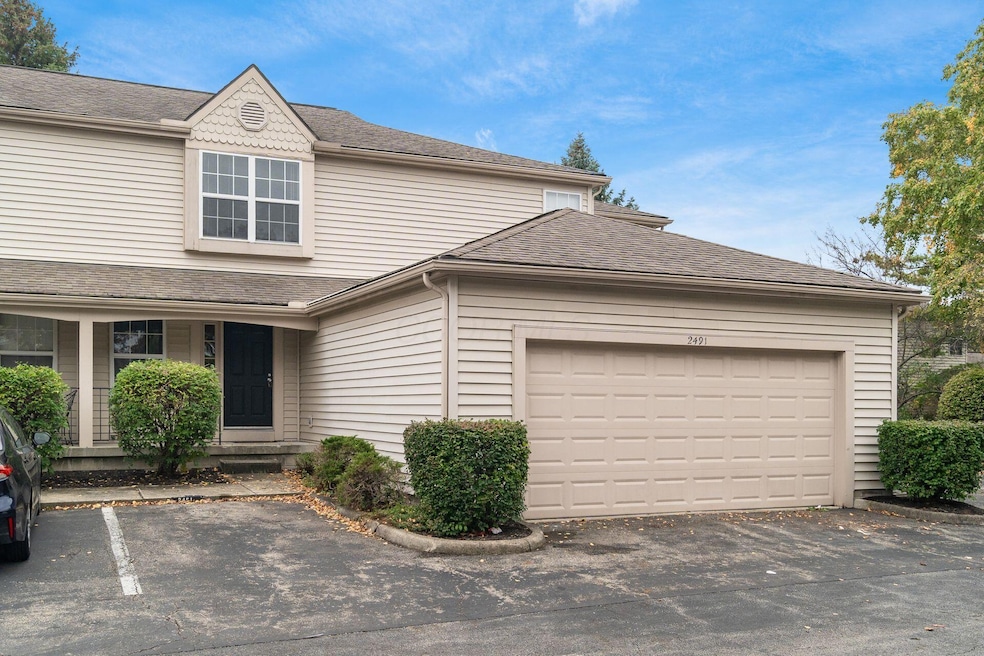

2491 Calais Way Columbus, OH 43235
Misty Meadows NeighborhoodEstimated payment $1,877/month
Highlights
- Fitness Center
- Clubhouse
- Community Pool
- Daniel Wright Elementary School Rated A-
- Traditional Architecture
- Fireplace
About This Home
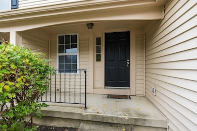
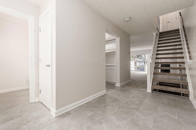
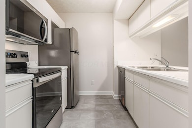
Spacious Bethel Village condo in the acclaimed Dublin School District featuring 2 bedrooms, 2.5 baths, and a large 2-car garage. New flooring throughout and an open-concept main level with a modern kitchen, stainless steel appliances, eat-in counter. Large living area with fireplace and sliding glass door. Entry level also includes half bath. Upstairs you will find two generous bedrooms both with their own dedicated full bath. Finished recreation in the lower level offers additional dining space. Lower level also has ample unfinished storage and bathroom rough-in. Convenient location with easy highway access close to Downtown Columbus, OSU, Polaris, Bridge Park and more!
Property Details
Home Type
- Condominium
Est. Annual Taxes
- $3,840
Year Built
- Built in 1994
Lot Details
- Two or More Common Walls
HOA Fees
- $240 Monthly HOA Fees
Parking
- 2 Car Attached Garage
- Off-Street Parking: 1
Home Design
- Traditional Architecture
- Block Foundation
- Vinyl Siding
Interior Spaces
- 1,252 Sq Ft Home
- 2-Story Property
- Fireplace
- Insulated Windows
Kitchen
- Electric Range
- Microwave
- Dishwasher
Flooring
- Carpet
- Ceramic Tile
Bedrooms and Bathrooms
- 2 Bedrooms
Basement
- Basement Fills Entire Space Under The House
- Recreation or Family Area in Basement
Utilities
- Forced Air Heating and Cooling System
- Heating System Uses Gas
Listing and Financial Details
- Assessor Parcel Number 590-230592
Community Details
Overview
- Association fees include lawn care, trash, water, snow removal
- Association Phone (614) 781-0055
- Towne Properties HOA
- On-Site Maintenance
Amenities
- Clubhouse
- Recreation Room
Recreation
- Fitness Center
- Community Pool
- Snow Removal
Map
Home Values in the Area
Average Home Value in this Area
Tax History
| Year | Tax Paid | Tax Assessment Tax Assessment Total Assessment is a certain percentage of the fair market value that is determined by local assessors to be the total taxable value of land and additions on the property. | Land | Improvement |
|---|---|---|---|---|
| 2024 | $8,868 | $73,290 | $15,750 | $57,540 |
| 2023 | $3,823 | $73,290 | $15,750 | $57,540 |
| 2022 | $3,198 | $58,590 | $9,100 | $49,490 |
| 2021 | $3,250 | $58,590 | $9,100 | $49,490 |
| 2020 | $3,230 | $58,590 | $9,100 | $49,490 |
| 2019 | $2,660 | $45,080 | $7,000 | $38,080 |
| 2018 | $2,387 | $45,080 | $7,000 | $38,080 |
| 2017 | $2,456 | $45,080 | $7,000 | $38,080 |
| 2016 | $2,091 | $37,810 | $7,250 | $30,560 |
| 2015 | $2,104 | $37,810 | $7,250 | $30,560 |
| 2014 | $2,106 | $37,810 | $7,250 | $30,560 |
| 2013 | $1,208 | $41,580 | $8,050 | $33,530 |
Property History
| Date | Event | Price | List to Sale | Price per Sq Ft |
|---|---|---|---|---|
| 10/24/2025 10/24/25 | For Sale | $249,900 | -- | $200 / Sq Ft |
Purchase History
| Date | Type | Sale Price | Title Company |
|---|---|---|---|
| Deed | $93,850 | -- |
Mortgage History
| Date | Status | Loan Amount | Loan Type |
|---|---|---|---|
| Closed | $95,727 | VA |
Source: Columbus and Central Ohio Regional MLS
MLS Number: 225040256
APN: 590-230592
Disclaimer: Certain information contained herein is derived from information provided by parties other than Homes.com. All information provided is deemed reliable, but is not guaranteed to be accurate and should be independently verified.
![]() IDX information is provided exclusively for personal, non-commercial use, and may not be used for any purpose other than to identify prospective properties consumers may be interested in purchasing.
IDX information is provided exclusively for personal, non-commercial use, and may not be used for any purpose other than to identify prospective properties consumers may be interested in purchasing.
Information is deemed reliable but not guaranteed.
- 2522 Gardenia Dr Unit 16C
- 5297 Brandy Oaks Ln Unit 5297
- 5273 Brandy Oaks Ln
- 2585 Trottersway Dr Unit 2585
- 5275 Brandy Oaks Ln
- 5294 Brandy Oaks Ln
- 5277 Brandy Oaks Ln
- 5322 Darlington Rd Unit E
- 2622 Trottersway Dr
- 2527 Maxim Ln Unit 40D
- 2560 Trotterslane Dr
- 2744 Greystone Dr Unit E
- 5283 Ruthton Rd Unit 19
- 5227 Brynwood Dr
- 5646 Dorsey Dr
- 5055 Slate Run Woods Ct
- 2236 Victoria Park Dr Unit 2236
- 5000 Slate Run Woods Ct
- 2265 Teardrop Ave Unit 39C
- 5718 Bangor Ct
- 2705 Greystone Dr Unit D
- 2733 Greystone Dr Unit D
- 5399 Coachman Rd
- 2283 Graydon Blvd
- 2265 Hedgerow Rd Unit D
- 4883 Stonehaven Dr
- 2225 Montego Blvd
- 5448 Maddens Pointe Ln
- 2255 Country Corners Dr
- 2078 Coleman Dr Unit 2078 Coleman dr
- 5265 Captains Ct
- 2980 Donnylane Blvd
- 5340 Shiloh Dr Unit 5340
- 3047 Bethel Rd
- 5211 Sawmill Rd
- 2081 Park Run Dr
- 5028 Dierker Rd
- 3113-3123 Francinelane Dr
- 3111 Hayden Rd
- 4867 Dierker Rd
