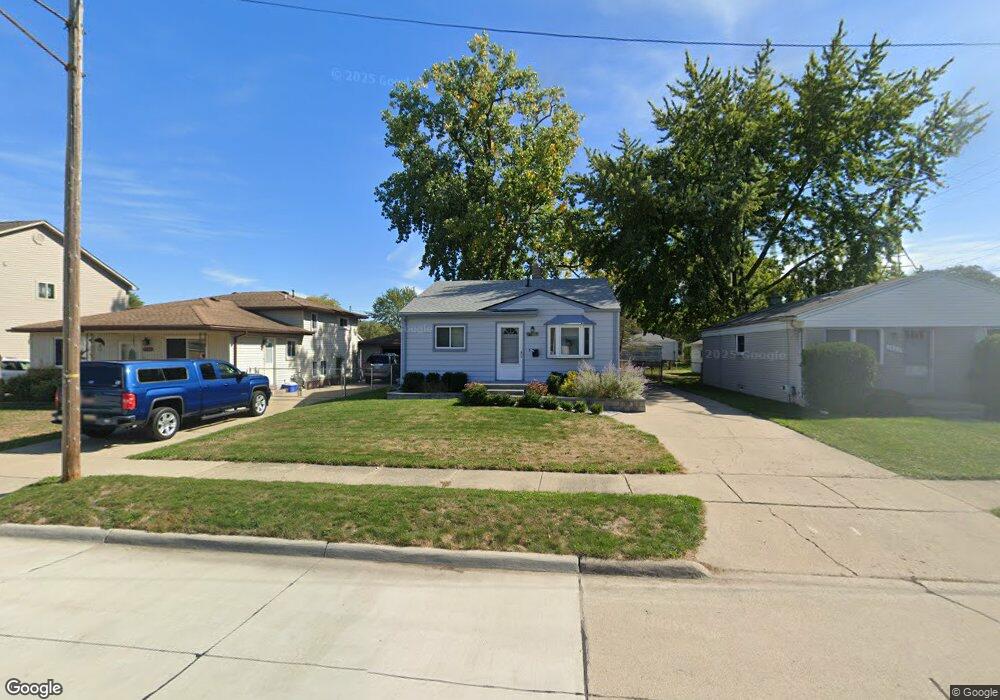
24920 Leo St Saint Clair Shores, MI 48080
Estimated Value: $202,000 - $252,000
2
Beds
1
Bath
1,300
Sq Ft
$169/Sq Ft
Est. Value
About This Home
This home is located at 24920 Leo St, Saint Clair Shores, MI 48080 and is currently estimated at $219,643, approximately $168 per square foot. 24920 Leo St is a home located in Macomb County with nearby schools including Lakeview High School and St. Isaac Jogues Elementary School.
Ownership History
Date
Name
Owned For
Owner Type
Purchase Details
Closed on
Sep 21, 2023
Sold by
Sandercott Michael Joseph
Bought by
Sandercott Michael Joseph
Current Estimated Value
Purchase Details
Closed on
May 5, 2010
Sold by
Paul George
Bought by
Sandercott Michael
Purchase Details
Closed on
Apr 23, 2010
Sold by
Hsbc Bank Usa Na
Bought by
Paul George
Purchase Details
Closed on
Jul 24, 2009
Sold by
Amyot Thomas E
Bought by
Hsbc Bank Usa Na
Purchase Details
Closed on
Feb 3, 2006
Sold by
Ruby Mary P
Bought by
Amyot Thomas E
Home Financials for this Owner
Home Financials are based on the most recent Mortgage that was taken out on this home.
Original Mortgage
$96,000
Interest Rate
6.2%
Mortgage Type
Fannie Mae Freddie Mac
Purchase Details
Closed on
Jan 21, 1997
Sold by
Cracchiolo S
Bought by
Amyot T
Create a Home Valuation Report for This Property
The Home Valuation Report is an in-depth analysis detailing your home's value as well as a comparison with similar homes in the area
Home Values in the Area
Average Home Value in this Area
Purchase History
| Date | Buyer | Sale Price | Title Company |
|---|---|---|---|
| Sandercott Michael Joseph | -- | None Listed On Document | |
| Sandercott Michael | $24,000 | Tri County Title Agency Inc | |
| Paul George | $18,000 | None Available | |
| Hsbc Bank Usa Na | $138,556 | None Available | |
| Amyot Thomas E | -- | Lenders Escrow & Title Agenc | |
| Amyot T | $55,000 | -- |
Source: Public Records
Mortgage History
| Date | Status | Borrower | Loan Amount |
|---|---|---|---|
| Previous Owner | Amyot Thomas E | $96,000 |
Source: Public Records
Tax History Compared to Growth
Tax History
| Year | Tax Paid | Tax Assessment Tax Assessment Total Assessment is a certain percentage of the fair market value that is determined by local assessors to be the total taxable value of land and additions on the property. | Land | Improvement |
|---|---|---|---|---|
| 2025 | $1,856 | $96,800 | $0 | $0 |
| 2024 | $1,856 | $88,000 | $0 | $0 |
| 2023 | $1,809 | $76,700 | $0 | $0 |
| 2022 | $1,715 | $68,000 | $0 | $0 |
| 2021 | $1,684 | $62,300 | $0 | $0 |
| 2020 | $1,690 | $56,600 | $0 | $0 |
| 2019 | $1,400 | $51,400 | $0 | $0 |
| 2018 | $1,537 | $40,500 | $0 | $0 |
| 2017 | $1,537 | $37,100 | $5,000 | $32,100 |
| 2016 | $1,400 | $37,100 | $0 | $0 |
| 2015 | $1,401 | $31,300 | $0 | $0 |
| 2012 | -- | $30,200 | $6,000 | $24,200 |
Source: Public Records
Map
Nearby Homes
- 21811 Lange St
- 22011 E 10 Mile Rd
- 21901 Trombly St
- 24709 Greater MacK Ave Unit 3
- 24917 Frederick St
- 22315 Kramer St
- 22029 Downing St
- 21805 Downing St
- 22031 Statler St
- 21728 Downing St
- 20859 Paloma St
- 21717 Madison St
- 22421 Maple St
- 21536 Downing St
- 21909 Stephens St
- 21636 Lakeland St
- 22022 Stephens St
- 22507 Beach St
- 22105 Ridgeway St
- 22473 Beach St
- 24924 Leo St
- 24916 Leo St
- 24930 Leo St
- 22005 Lange St
- 22001 Lange St
- 24919 Norval St
- 22009 Lange St
- 24915 Norval St
- 24923 Norval St
- 22012 E 10 Mile Rd
- 22004 E 10 Mile Rd
- 21935 Lange St
- 22000 E 10 Mile Rd
- 22019 Lange St
- 22008 E 10 Mile Rd
- 24927 Norval St
- 24921 Leo St
- 24925 Leo St
- 21929 Lange St
- 24917 Leo St