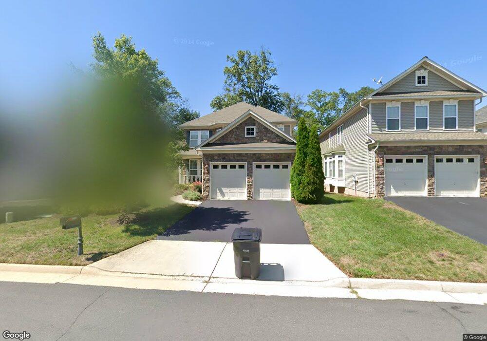
24953 Devonian Dr Stone Ridge, VA 20105
Estimated Value: $901,000 - $960,000
4
Beds
4
Baths
2,994
Sq Ft
$315/Sq Ft
Est. Value
About This Home
This home is located at 24953 Devonian Dr, Stone Ridge, VA 20105 and is currently estimated at $942,902, approximately $314 per square foot. 24953 Devonian Dr is a home located in Loudoun County with nearby schools including Arcola Elementary School, Mercer Middle School, and John Champe High School.
Ownership History
Date
Name
Owned For
Owner Type
Purchase Details
Closed on
Jun 27, 2008
Sold by
Van Metre Homes @ Stoneri
Bought by
Walsh William R
Current Estimated Value
Home Financials for this Owner
Home Financials are based on the most recent Mortgage that was taken out on this home.
Original Mortgage
$80,050
Outstanding Balance
$51,904
Interest Rate
6.17%
Mortgage Type
New Conventional
Estimated Equity
$890,998
Create a Home Valuation Report for This Property
The Home Valuation Report is an in-depth analysis detailing your home's value as well as a comparison with similar homes in the area
Home Values in the Area
Average Home Value in this Area
Purchase History
| Date | Buyer | Sale Price | Title Company |
|---|---|---|---|
| Walsh William R | $538,387 | -- |
Source: Public Records
Mortgage History
| Date | Status | Borrower | Loan Amount |
|---|---|---|---|
| Open | Walsh William R | $80,050 |
Source: Public Records
Tax History
| Year | Tax Paid | Tax Assessment Tax Assessment Total Assessment is a certain percentage of the fair market value that is determined by local assessors to be the total taxable value of land and additions on the property. | Land | Improvement |
|---|---|---|---|---|
| 2025 | $7,494 | $930,980 | $281,700 | $649,280 |
| 2024 | $7,759 | $897,040 | $271,700 | $625,340 |
| 2023 | $7,270 | $830,910 | $271,700 | $559,210 |
| 2022 | $6,910 | $776,410 | $241,700 | $534,710 |
| 2021 | $6,519 | $665,240 | $206,700 | $458,540 |
| 2020 | $6,433 | $621,570 | $196,700 | $424,870 |
| 2019 | $6,229 | $596,120 | $196,700 | $399,420 |
| 2018 | $6,343 | $584,620 | $176,700 | $407,920 |
| 2017 | $6,244 | $555,000 | $176,700 | $378,300 |
| 2016 | $6,412 | $559,990 | $0 | $0 |
| 2015 | $6,404 | $387,500 | $0 | $387,500 |
| 2014 | $6,126 | $353,720 | $0 | $353,720 |
Source: Public Records
Map
Nearby Homes
- 25076 Cypress Mill Terrace
- 25152 Boomerang Terrace
- 42258 Dean Chapel Square
- 42094 Fiddlehead Place
- 42304 Lancaster Woods Square
- 24878 Helms Terrace
- 41928 Beryl Terrace
- 42261 Terrazzo Terrace
- 24684 Rosebay Terrace
- 42260 Terrazzo Terrace
- 24829 Coats Square
- 42346 Ponderosa Dr
- 24662 Kings Canyon Square
- 25265 Oribi Place
- 42260 Black Rock Terrace
- 24546 Byrne Meadow Square
- 24636 Greysteel Square
- 24672 Byrne Meadow Square
- 24660 Woolly Mammoth Terrace Unit 305
- 25278 Boldness Ct
- 24957 Devonian Dr
- 24949 Devonian Dr
- 24961 Devonian Dr
- 24945 Devonian Dr
- 42044 Basalt Dr
- 24965 Devonian Dr
- 42049 Greenstone Dr
- 42048 Basalt Dr
- 24969 Devonian Dr
- 42053 Greenstone Dr
- 42052 Basalt Dr
- 42057 Greenstone Dr
- 42045 Basalt Dr
- 42043 Pepperbush Place
- 42039 Pepperbush Place
- 42056 Basalt Dr
- 42047 Pepperbush Place
- 42049 Basalt Dr
- 42061 Greenstone Dr
- 42035 Pepperbush Place
Your Personal Tour Guide
Ask me questions while you tour the home.