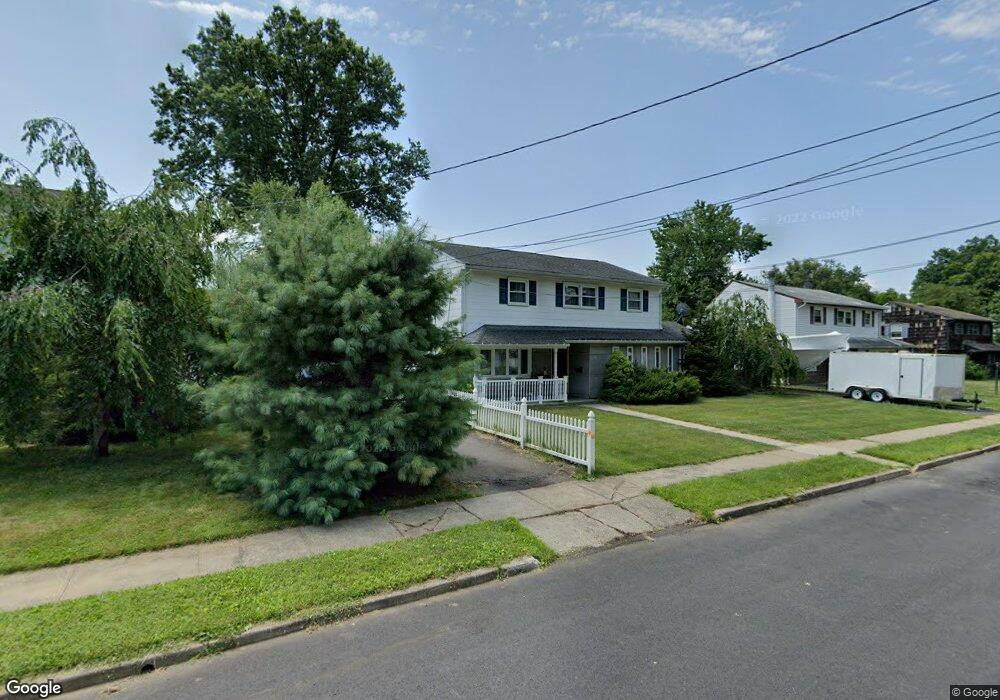
25 E E Locust Ave Colonia, NJ 07042
Estimated Value: $526,580 - $625,000
4
Beds
2
Baths
1,789
Sq Ft
$330/Sq Ft
Est. Value
About This Home
This home is located at 25 E E Locust Ave, Colonia, NJ 07042 and is currently estimated at $590,395, approximately $330 per square foot. 25 E E Locust Ave is a home located in Middlesex County with nearby schools including Oak Ridge Heights Elementary School, Colonia Middle School, and Colonia High School.
Ownership History
Date
Name
Owned For
Owner Type
Purchase Details
Closed on
Apr 17, 2025
Sold by
Bkpl-Eg Basket Trust and Us Bank Trust National Assocation
Bought by
Patel Mayankkumar M and Patel Monika Prahladbhai
Current Estimated Value
Home Financials for this Owner
Home Financials are based on the most recent Mortgage that was taken out on this home.
Original Mortgage
$415,000
Outstanding Balance
$407,811
Interest Rate
6.03%
Mortgage Type
New Conventional
Estimated Equity
$182,584
Purchase Details
Closed on
Jul 17, 2024
Sold by
Middlesex County Sheriffs
Bought by
Bkpl-Eg Basket Trust and Us Bank Trust
Purchase Details
Closed on
Jun 2, 2006
Purchase Details
Closed on
Sep 29, 1997
Sold by
Hayward Scott
Bought by
Ansaldo Michael and Ansaldo Susan
Home Financials for this Owner
Home Financials are based on the most recent Mortgage that was taken out on this home.
Original Mortgage
$146,000
Interest Rate
7.46%
Create a Home Valuation Report for This Property
The Home Valuation Report is an in-depth analysis detailing your home's value as well as a comparison with similar homes in the area
Home Values in the Area
Average Home Value in this Area
Purchase History
| Date | Buyer | Sale Price | Title Company |
|---|---|---|---|
| Patel Mayankkumar M | $595,000 | None Listed On Document | |
| Bkpl-Eg Basket Trust | $561,458 | None Listed On Document | |
| -- | -- | -- | |
| Ansaldo Michael | $172,000 | -- |
Source: Public Records
Mortgage History
| Date | Status | Borrower | Loan Amount |
|---|---|---|---|
| Open | Patel Mayankkumar M | $415,000 | |
| Previous Owner | Ansaldo Michael | $146,000 |
Source: Public Records
Tax History
| Year | Tax Paid | Tax Assessment Tax Assessment Total Assessment is a certain percentage of the fair market value that is determined by local assessors to be the total taxable value of land and additions on the property. | Land | Improvement |
|---|---|---|---|---|
| 2025 | $11,616 | $96,000 | $25,600 | $70,400 |
| 2024 | $11,364 | $96,000 | $25,600 | $70,400 |
| 2023 | $11,364 | $96,000 | $25,600 | $70,400 |
| 2022 | $11,082 | $96,000 | $25,600 | $70,400 |
| 2021 | $10,991 | $96,000 | $25,600 | $70,400 |
| 2020 | $10,660 | $96,000 | $25,600 | $70,400 |
| 2019 | $10,407 | $96,000 | $25,600 | $70,400 |
| 2018 | $10,210 | $96,000 | $25,600 | $70,400 |
| 2017 | $10,030 | $96,000 | $25,600 | $70,400 |
| 2016 | $9,952 | $96,000 | $25,600 | $70,400 |
| 2015 | $9,778 | $96,000 | $25,600 | $70,400 |
| 2014 | $9,568 | $96,000 | $25,600 | $70,400 |
Source: Public Records
Map
Nearby Homes
- 34 E Prescott Ave
- 37 E Hegel Ave
- 973 Ellis Pkwy
- 8 Periwinkle Place
- 868 Inman Ave
- 8 Normandy Rd
- 53 Jordan Rd
- 265 W Prescott Ave
- 67 Brookside Terrace
- 131 Morningside Rd
- 24 Woodland Rd
- 12 W Clark Place
- 80 Gaywood Ave
- 172 Briarheath Ln
- 15 New Dover Ave
- 64 William St
- 46 Taylor Terrace
- 6 Tulip Ct
- 2 Cherbar Ct
- 990 Inman Ave
- 17 E Locust Ave
- 31 E Locust Ave
- 26 E Locust Ave
- 26 E Shirley Ave
- 13 E Locust Ave
- 20 E Locust Ave
- 20 E Shirley Ave
- 32 E Locust Ave
- 37 E Locust Ave
- 32 E Shirley Ave
- 14 E Locust Ave
- 38 E Locust Ave
- 38 E Shirley Ave
- 318 Cypress Dr
- 43 E Locust Ave
- 21 E Prescott Ave
- 324 Cypress Dr
- 17 E Prescott Ave
- 27 E Prescott Ave
- 44 E Locust Ave
Your Personal Tour Guide
Ask me questions while you tour the home.