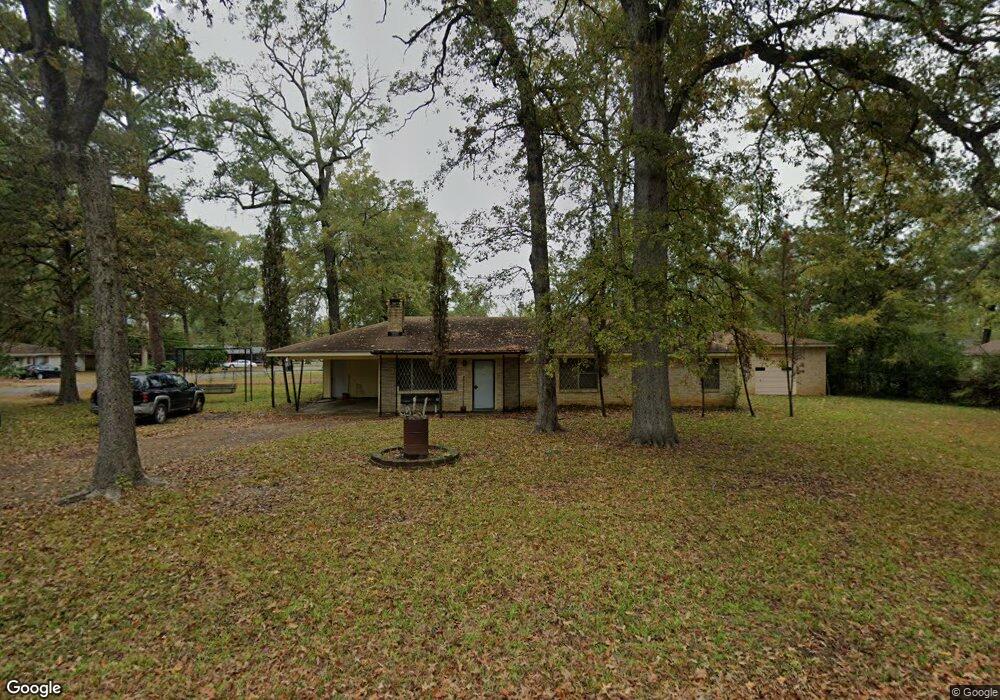
25 Kathy Ln Monroe, LA 71203
Estimated Value: $140,081 - $180,000
3
Beds
2
Baths
1,708
Sq Ft
$97/Sq Ft
Est. Value
About This Home
This home is located at 25 Kathy Ln, Monroe, LA 71203 and is currently estimated at $166,270, approximately $97 per square foot. 25 Kathy Ln is a home located in Ouachita Parish with nearby schools including Jack Hayes Elementary School, Ouachita Junior High School, and Ouachita Parish High School.
Ownership History
Date
Name
Owned For
Owner Type
Purchase Details
Closed on
Jan 26, 2006
Sold by
Purdy Stevens Jettie Pearl
Bought by
Lowe Gowan Gary and Stevens Gowan Betty Jean
Current Estimated Value
Home Financials for this Owner
Home Financials are based on the most recent Mortgage that was taken out on this home.
Original Mortgage
$86,850
Interest Rate
5.69%
Mortgage Type
Purchase Money Mortgage
Create a Home Valuation Report for This Property
The Home Valuation Report is an in-depth analysis detailing your home's value as well as a comparison with similar homes in the area
Purchase History
| Date | Buyer | Sale Price | Title Company |
|---|---|---|---|
| Lowe Gowan Gary | $108,600 | Mahony Title Services |
Source: Public Records
Mortgage History
| Date | Status | Borrower | Loan Amount |
|---|---|---|---|
| Closed | Lowe Gowan Gary | $86,850 |
Source: Public Records
Tax History
| Year | Tax Paid | Tax Assessment Tax Assessment Total Assessment is a certain percentage of the fair market value that is determined by local assessors to be the total taxable value of land and additions on the property. | Land | Improvement |
|---|---|---|---|---|
| 2025 | $1,749 | $11,577 | $1,700 | $9,877 |
| 2024 | $1,749 | $11,577 | $1,700 | $9,877 |
| 2023 | $718 | $9,557 | $1,700 | $7,857 |
| 2022 | $1,436 | $9,557 | $1,700 | $7,857 |
| 2021 | $1,447 | $10,296 | $1,700 | $8,596 |
| 2020 | $1,493 | $10,553 | $1,700 | $8,853 |
| 2019 | $1,473 | $10,553 | $1,700 | $8,853 |
| 2018 | $419 | $10,553 | $1,700 | $8,853 |
| 2017 | $1,287 | $9,498 | $1,530 | $7,968 |
| 2016 | $1,054 | $10,554 | $1,700 | $8,854 |
| 2015 | $418 | $10,554 | $1,700 | $8,854 |
| 2014 | $423 | $10,554 | $1,700 | $8,854 |
| 2013 | $1,404 | $10,554 | $1,700 | $8,854 |
Source: Public Records
Map
Nearby Homes
- 24 Elmwood Dr
- 31 Azalea Dr
- 10 Rosewood Dr
- 26 Karen Ln
- 308 Woodale Dr Unit 2
- 55 Magnolia Dr
- 303 Woodale Dr
- 26 Jana Dr
- 117 Oak Cir
- 37 W Elmwood Dr
- 0 Old Sterlington Rd
- 101 Tulip Wood Dr Unit 1
- 219 Sterlington Dr
- 0 Sterlington Rd
- 256 N Leo Ln
- 311 Birdie Ln
- 000 Stubbs Vinson Rd
- 292 Birdie Ln
- 303 Birdie Ln
- 135 N Leo Ln
Your Personal Tour Guide
Ask me questions while you tour the home.