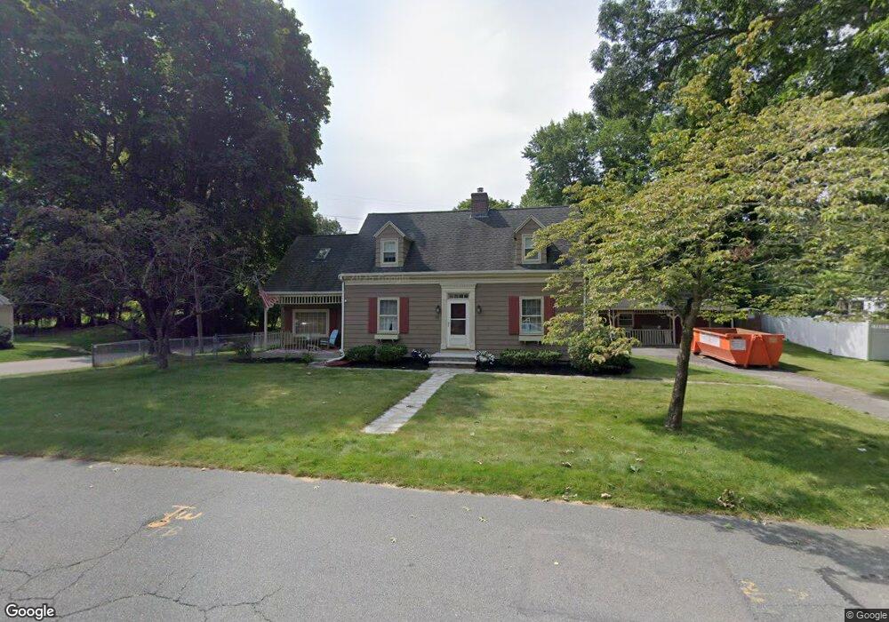
25 Kimball Rd Methuen, MA 01844
The West End NeighborhoodEstimated Value: $634,000 - $652,000
3
Beds
3
Baths
2,148
Sq Ft
$300/Sq Ft
Est. Value
About This Home
This home is located at 25 Kimball Rd, Methuen, MA 01844 and is currently estimated at $645,399, approximately $300 per square foot. 25 Kimball Rd is a home located in Essex County with nearby schools including Mendota Elementary School, Tenney Grammar School, and South Point Elementary School.
Ownership History
Date
Name
Owned For
Owner Type
Purchase Details
Closed on
Jul 3, 2017
Sold by
Bennett Leeann M
Bought by
Bennett Leeann M and Bennett Steven A
Current Estimated Value
Purchase Details
Closed on
Sep 16, 2005
Sold by
Neel-Desrochers Maureen
Bought by
Bennett Leeann M
Home Financials for this Owner
Home Financials are based on the most recent Mortgage that was taken out on this home.
Original Mortgage
$294,000
Interest Rate
5.84%
Mortgage Type
Purchase Money Mortgage
Create a Home Valuation Report for This Property
The Home Valuation Report is an in-depth analysis detailing your home's value as well as a comparison with similar homes in the area
Home Values in the Area
Average Home Value in this Area
Purchase History
| Date | Buyer | Sale Price | Title Company |
|---|---|---|---|
| Bennett Leeann M | -- | -- | |
| Bennett Leeann M | -- | -- | |
| Bennett Leeann M | -- | -- | |
| Bennett Leeann M | $367,500 | -- | |
| Bennett Leeann M | $367,500 | -- |
Source: Public Records
Mortgage History
| Date | Status | Borrower | Loan Amount |
|---|---|---|---|
| Previous Owner | Bennett Leeann M | $294,000 | |
| Previous Owner | Bennett Leeann M | $26,000 |
Source: Public Records
Tax History Compared to Growth
Tax History
| Year | Tax Paid | Tax Assessment Tax Assessment Total Assessment is a certain percentage of the fair market value that is determined by local assessors to be the total taxable value of land and additions on the property. | Land | Improvement |
|---|---|---|---|---|
| 2025 | $5,913 | $558,900 | $229,200 | $329,700 |
| 2024 | $5,779 | $532,100 | $208,400 | $323,700 |
| 2023 | $5,418 | $463,100 | $186,100 | $277,000 |
| 2022 | $5,044 | $386,500 | $148,900 | $237,600 |
| 2021 | $4,791 | $363,200 | $141,400 | $221,800 |
| 2020 | $4,797 | $356,900 | $141,400 | $215,500 |
| 2019 | $4,677 | $329,600 | $134,000 | $195,600 |
| 2018 | $4,569 | $320,200 | $134,000 | $186,200 |
| 2017 | $4,413 | $301,200 | $134,000 | $167,200 |
| 2016 | $4,228 | $285,500 | $134,000 | $151,500 |
| 2015 | $3,990 | $273,300 | $134,000 | $139,300 |
Source: Public Records
Map
Nearby Homes
- 26 Gage St
- 52 High St Unit 5
- 35 Stillwater Rd
- 40 Carol Ave
- 32 Morrison Ct
- 174 Pleasant St
- 47 Lowell St
- 20 Bruce St
- 48 Pond St
- 19 Hampshire Rd Unit 304
- 21 Hampshire Rd Unit 412
- 0 Hampshire Rd
- 23 Hampshire Rd Unit 404
- 35 Hardy St
- 83 Arnold St
- 97-99 Lowell St
- 2 Horne St
- 100-102 Phillips St
- 24 Railroad St
- 48 Larchwood Rd
- 17 Kimball Rd
- 18 Stanley Rd
- 29 Kimball Rd
- 22 Kimball Rd
- 20 Kimball Rd
- 30 Kimball Rd
- 15 Kimball Rd
- 15 Kimball Rd Unit 15
- 18 Kimball Rd
- 14 Stanley Rd Unit 16
- 33 Kimball Rd
- 14-16 Stanley Rd
- 0 Confidential Ln Unit 70883196
- 0 Confidential St Unit 70948235
- 01 Confidential Ln
- 28
- 0 Confidential St Unit 71311959
- 0 Confidential St Unit 4768115
- 16 Kimball Rd
- 34 Kimball Rd