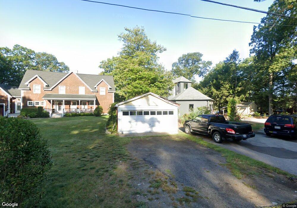
25 Lake St Wrentham, MA 02093
Estimated Value: $1,002,000 - $1,455,000
4
Beds
2
Baths
1,907
Sq Ft
$637/Sq Ft
Est. Value
About This Home
This home is located at 25 Lake St, Wrentham, MA 02093 and is currently estimated at $1,214,489, approximately $636 per square foot. 25 Lake St is a home located in Norfolk County with nearby schools including Delaney Elementary School and Charles E Roderick.
Ownership History
Date
Name
Owned For
Owner Type
Purchase Details
Closed on
Feb 24, 2006
Sold by
Duprey Richard E and Stauff Vera M
Bought by
Kearney Christine and Kearney James T
Current Estimated Value
Create a Home Valuation Report for This Property
The Home Valuation Report is an in-depth analysis detailing your home's value as well as a comparison with similar homes in the area
Home Values in the Area
Average Home Value in this Area
Purchase History
| Date | Buyer | Sale Price | Title Company |
|---|---|---|---|
| Kearney Christine | $570,000 | -- |
Source: Public Records
Tax History Compared to Growth
Tax History
| Year | Tax Paid | Tax Assessment Tax Assessment Total Assessment is a certain percentage of the fair market value that is determined by local assessors to be the total taxable value of land and additions on the property. | Land | Improvement |
|---|---|---|---|---|
| 2025 | $13,455 | $1,160,900 | $520,700 | $640,200 |
| 2024 | $12,952 | $1,079,300 | $520,700 | $558,600 |
| 2023 | $12,670 | $1,004,000 | $473,400 | $530,600 |
| 2022 | $12,038 | $880,600 | $420,200 | $460,400 |
| 2021 | $11,231 | $798,200 | $373,100 | $425,100 |
| 2020 | $12,650 | $887,700 | $406,800 | $480,900 |
| 2019 | $12,677 | $897,800 | $438,100 | $459,700 |
| 2018 | $12,011 | $843,500 | $438,900 | $404,600 |
| 2017 | $11,739 | $823,800 | $430,400 | $393,400 |
| 2016 | $11,538 | $808,000 | $417,900 | $390,100 |
| 2015 | $11,407 | $761,500 | $401,800 | $359,700 |
| 2014 | $11,277 | $736,600 | $386,400 | $350,200 |
Source: Public Records
Map
Nearby Homes
- 10 Nature View Dr
- 15 Nature View Dr
- 131 Creek St Unit 7
- 570 Franklin St
- 11 Earle Stewart Ln
- Lot 3 - 14 Earle Stewart Ln
- 270 Dedham St
- Lot 1 - Blueberry 2 Car Plan at King Philip Estates
- Lot 8 - Blueberry 2 Car Plan at King Philip Estates
- Lot 6 - Blueberry 3 Car Plan at King Philip Estates
- Lot 2 - Camden 2 Car Plan at King Philip Estates
- Lot 7 - Cedar Plan at King Philip Estates
- Lot 4 - Hemingway 2 Car Plan at King Philip Estates
- Lot 3 - Blueberry 2 Car Plan at King Philip Estates
- 1 Lorraine Metcalf Dr
- 50 Reed Fulton Ave Unit Lot 61
- 319 Taunton St
- 246 Forest Grove Ave
- 362 East St
- 45 Joshua Rd