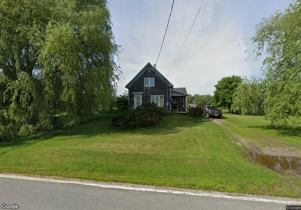
25 New Rd Penobscot, ME 04476
Estimated Value: $252,000 - $371,000
--
Bed
--
Bath
968
Sq Ft
$303/Sq Ft
Est. Value
About This Home
This home is located at 25 New Rd, Penobscot, ME 04476 and is currently estimated at $293,273, approximately $302 per square foot. 25 New Rd is a home with nearby schools including Penobscot Elementary School.
Ownership History
Date
Name
Owned For
Owner Type
Purchase Details
Closed on
May 7, 2025
Sold by
Cavanaugh Hamilton L
Bought by
Chapman Cameron R
Current Estimated Value
Purchase Details
Closed on
Mar 16, 2022
Sold by
Cavanaugh Hamilton L
Bought by
Cavanaugh Hamilton L and Dinsmore Robert B
Purchase Details
Closed on
Jun 1, 2017
Sold by
Cavanaugh Hamilton L
Bought by
Dinsmore Robert B and Fernandes Freny J
Create a Home Valuation Report for This Property
The Home Valuation Report is an in-depth analysis detailing your home's value as well as a comparison with similar homes in the area
Home Values in the Area
Average Home Value in this Area
Purchase History
| Date | Buyer | Sale Price | Title Company |
|---|---|---|---|
| Chapman Cameron R | -- | None Available | |
| Chapman Cameron R | -- | None Available | |
| Chapman Cameron R | -- | None Available | |
| Cavanaugh Hamilton L | -- | None Available | |
| Cavanaugh Hamilton L | -- | None Available | |
| Cavanaugh Hamilton L | -- | None Available | |
| Dinsmore Robert B | -- | -- | |
| Dinsmore Robert B | -- | -- | |
| Dinsmore Robert B | -- | -- |
Source: Public Records
Tax History Compared to Growth
Tax History
| Year | Tax Paid | Tax Assessment Tax Assessment Total Assessment is a certain percentage of the fair market value that is determined by local assessors to be the total taxable value of land and additions on the property. | Land | Improvement |
|---|---|---|---|---|
| 2025 | $1,745 | $183,500 | $80,000 | $103,500 |
| 2024 | $1,623 | $146,100 | $63,700 | $82,400 |
| 2023 | $1,527 | $146,100 | $63,700 | $82,400 |
| 2022 | $1,449 | $127,100 | $55,400 | $71,700 |
| 2021 | $1,373 | $127,100 | $55,400 | $71,700 |
| 2020 | $1,322 | $127,100 | $55,400 | $71,700 |
| 2019 | $1,341 | $127,100 | $55,400 | $71,700 |
| 2018 | $1,233 | $127,100 | $55,400 | $71,700 |
| 2017 | $1,512 | $127,100 | $55,400 | $71,700 |
| 2016 | $1,449 | $127,100 | $55,400 | $71,700 |
| 2014 | $1,378 | $141,300 | $61,600 | $79,700 |
| 2013 | $1,286 | $141,300 | $61,600 | $79,700 |
Source: Public Records
Map
Nearby Homes
- 352 Bayview Rd
- MAP13LOT21 Maine 199
- 26 Jenkins Rd
- 269 Wardwell Point Rd
- 64 New Homestead Rd
- 00 Dunbar
- 113 Wardwell Point Rd
- 99 Southern Bay Rd
- 15 Maine 166
- 142 Southern Bay Rd
- 1114 Castine Rd
- 1026 Castine Rd
- 684 the Shore Rd
- M13, L36 Harland Cunningham Rd
- 581 the Shore Rd
- Map4 Lot26 Graytown Rd
- 163 Hersey Retreat Rd
- 115 Pirates Cove Rd
- 115A&B Pirates Cove Rd
- 40 Loon Landing