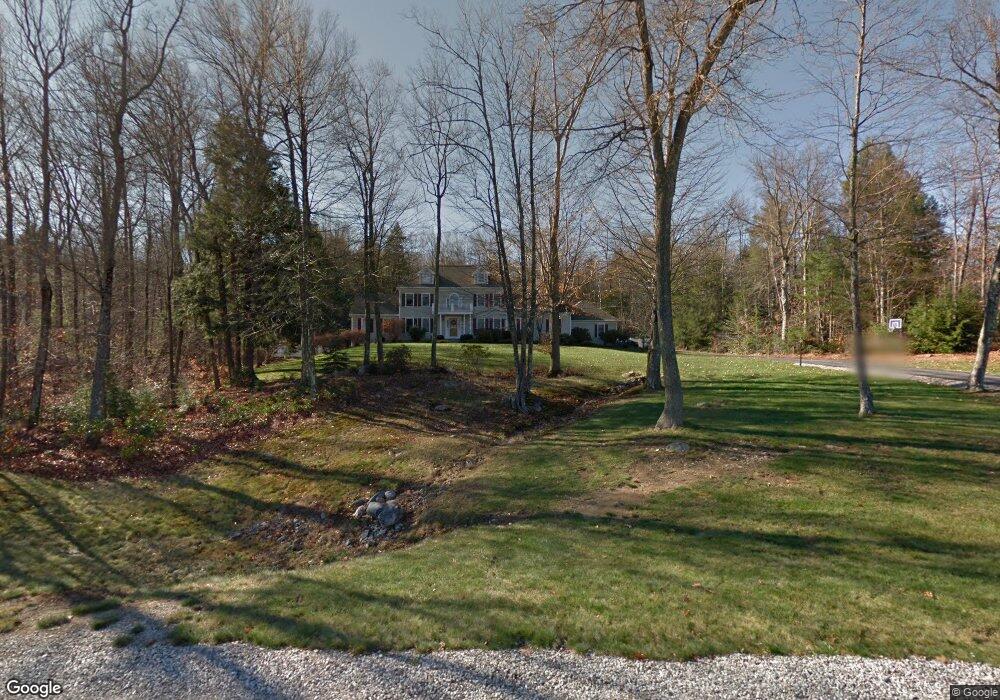
25 Newfane Rd Bedford, NH 03110
Bedford NeighborhoodEstimated Value: $1,312,000 - $1,464,000
5
Beds
5
Baths
4,266
Sq Ft
$324/Sq Ft
Est. Value
About This Home
This home is located at 25 Newfane Rd, Bedford, NH 03110 and is currently estimated at $1,383,547, approximately $324 per square foot. 25 Newfane Rd is a home located in Hillsborough County with nearby schools including Mckelvie Intermediate School, Ross A. Lurgio Middle School, and Bedford High School.
Ownership History
Date
Name
Owned For
Owner Type
Purchase Details
Closed on
Jul 14, 2000
Sold by
William P Heidt Rvkbl
Bought by
Deris John A and Deris Eileen M
Current Estimated Value
Home Financials for this Owner
Home Financials are based on the most recent Mortgage that was taken out on this home.
Original Mortgage
$330,000
Interest Rate
8.5%
Create a Home Valuation Report for This Property
The Home Valuation Report is an in-depth analysis detailing your home's value as well as a comparison with similar homes in the area
Home Values in the Area
Average Home Value in this Area
Purchase History
We collect this data history from publicly available records. To have your information removed, we recommend requesting removal directly through your county’s website.
| Date | Buyer | Sale Price | Title Company |
|---|---|---|---|
| Deris John A | $515,000 | -- |
Source: Public Records
Mortgage History
We collect this data history from publicly available records. To have your information removed, we recommend requesting removal directly through your county’s website.
| Date | Status | Borrower | Loan Amount |
|---|---|---|---|
| Open | Deris John A | $284,000 | |
| Closed | Deris John A | $300,000 | |
| Closed | Deris John A | $330,000 |
Source: Public Records
Tax History
| Year | Tax Paid | Tax Assessment Tax Assessment Total Assessment is a certain percentage of the fair market value that is determined by local assessors to be the total taxable value of land and additions on the property. | Land | Improvement |
|---|---|---|---|---|
| 2025 | $20,837 | $1,263,600 | $299,200 | $964,400 |
| 2024 | $19,978 | $1,263,600 | $299,200 | $964,400 |
| 2023 | $18,358 | $1,240,400 | $299,200 | $941,200 |
| 2022 | $16,039 | $911,300 | $221,700 | $689,600 |
| 2021 | $15,620 | $911,300 | $221,700 | $689,600 |
| 2020 | $15,840 | $791,200 | $170,500 | $620,700 |
| 2019 | $14,993 | $791,200 | $170,500 | $620,700 |
| 2018 | $15,267 | $748,400 | $170,500 | $577,900 |
| 2017 | $14,152 | $748,400 | $170,500 | $577,900 |
| 2016 | $14,717 | $657,900 | $130,800 | $527,100 |
| 2015 | $14,974 | $657,900 | $130,800 | $527,100 |
| 2014 | $14,803 | $657,900 | $130,800 | $527,100 |
| 2013 | $14,586 | $657,900 | $130,800 | $527,100 |
Source: Public Records
Map
Nearby Homes
- 50 Newfane Rd
- 281 New Boston Rd
- 28 Olde Lantern Rd
- 336 New Boston Rd
- 47 Hawk Dr
- 9 Tuttle Rd
- 49 Birkdale Rd
- 12 Magazine St
- 17 Canterbury Ln
- 75 Birkdale Rd
- 99 Cambridge Rd
- 5 Millstone Terrace
- 123 Stephen Dr
- 22 Elizabeth Way
- 30 Mill Stone Terrace
- 10 Lilac Ct
- 5 Spring Hill Rd
- 10 Ellison Dr
- 1 Cobtail Way
- 31 Boxwood Rd
Your Personal Tour Guide
Ask me questions while you tour the home.